
Country Canada Founded 1882 Demonym(s) Red Deerian Local time Sunday 12:23 AM | Census division 8 Elevation 855 m (2,805 ft) Area 69.23 km² Population 100,418 (2016) | |
 | ||
Weather 2°C, Wind W at 11 km/h, 68% Humidity | ||
Red Deer is a city in Central Alberta, Canada. It is located near the midpoint of the Calgary–Edmonton Corridor and is surrounded by Red Deer County. It is Alberta's third-most-populous city – after Calgary and Edmonton. The city is located in aspen parkland, a region of rolling hills that is home to oil, grain, and cattle production. It is a centre for oil and agriculture distribution, and the surrounding region is a major centre for petrochemical production. Red Deer had a population of 100,418 as of the Canada 2016 census making Red Deer Alberta's third city to surpass a population count of 100,000 people.
Contents
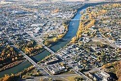
- Map of Red Deer AB Canada
- Red deer alberta canada tourism red deer summer
- History
- Name origin
- Leonard Gaetz
- 1900 to 1929
- 1930 to 1945
- Post Second World War
- Geography
- Climate
- Neighbourhoods
- Demographics
- Arts and culture
- Sports
- Transportation
- Health care
- Water
- Wastewater
- Secondary
- Post secondary
- Private schools
- References
Map of Red Deer, AB, Canada
Red deer alberta canada tourism red deer summer
History
Prior to European settlement, the area was a gathering place that was inhabited by Aboriginal tribes including the Blackfoot, Plains Cree and Stoney. European fur traders began passing through the area in the late eighteenth century. Into this ethnic mix, the Métis peoples also emerged.
A native trail ran from Montana in the south across the Bow River near Calgary and on to Fort Edmonton. About halfway between Calgary and Edmonton, the trail crossed the Red Deer River at a wide, stony shallow used by First Nations peoples and bison, commonly known as buffalo, since ancient times. The shallows, now known as the Old Red Deer Crossing, are about 7 kilometres (4.3 mi) upstream from the present City of Red Deer.
With the establishment of Fort Calgary by the North-West Mounted Police in 1875, traffic increased along what was by then known as the Calgary and Edmonton Trail. After the arrival of the Canadian Pacific Railway in Calgary, traffic along the "C & E" trail increased substantially. A trading post and stopping house were built at the Crossing in 1882 and a permanent settlement began to develop around it.
During the 1885 Riel Rebellion (also known as the North-West Rebellion), the Canadian militia constructed Fort Normandeau at the Crossing. The fort was later taken over by the North-West Mounted Police who used it until 1893.
With the decimation of the bison by hunters, the Aboriginal tribes who relied on them for food, clothing and shelter were also in decline. The fertile lands around the Red Deer River were attractive to farmers and ranchers. One early settler, the Reverend Leonard Gaetz, gave a half-share of 1,240 acres (5.0 km2) he had acquired to the Calgary and Edmonton Railway to develop a bridge over the river and a townsite. As a result, the Crossing was gradually abandoned. The first train from Calgary to Edmonton passed through Red Deer in 1891.
Name origin
The Cree peoples called the river on which Red Deer stands Waskasoo Seepee, which translates to "Elk River". However, British traders translated the name as "Red Deer River", since they mistakenly thought elk were European red deer. Later, the settlers of the area named their community after the river. The name for the modern city in Plains Cree is a calque back from English of the mistranslated, mihkwâpisimosos literally "red type of deer" while the name of the river itself is still wâwâskêsiw-sîpiy or "elk river".
Leonard Gaetz
Leonard Gaetz acted as the local land agent for the Saskatchewan Colonization Company and purchased parts of three other sections from his employers. By 1890, the Gaetz family owned vast land holdings along the south bank of the Red Deer River around the mouth of the Waskasoo Creek. The holdings included parts of Sections 16, 17, 20 and 21. Leonard Gaetz's increasing wealth allowed his family to play a central role in the growth of Red Deer.
In 1895, Gaetz returned to the active ministry in Manitoba. Once again, this proved detrimental to his health. He retired back to Red Deer in 1901, and resided here for the remainder of his life. He was a strong promoter of the area, founding the Westerner showgrounds and annual "Westerner Days", akin to the Calgary Stampede. He died in Red Deer in 1907.
1900 to 1929
Red Deer saw a massive influx of settlers in the early 1900s.
In 1901, when Red Deer was incorporated as a town, the population stood at 343. Through its location midway between Edmonton and Calgary and the fertile land that supported profitable mixed farming, Red Deer developed primarily as an agricultural service and distribution centre. A further boost came in 1907 when it was chosen as a major divisional point for the Canadian Pacific Railway. Two other railways, the Alberta Central Railway and the Canadian Northern Railway, entered the community in 1911. Red Deer underwent a large land boom.
On March 25, 1913, Red Deer was incorporated as a city and the population had jumped to nearly 2,800.
World War I brought a sharp end to the boom. Red Deer emerged as a small, quiet, but prosperous, prairie city. In 1922, the provincial institution for the care of the mentally handicapped, currently known as the Michener Centre, was established in the city. Prospects looked good for modest but sustainable growth.
1930 to 1945
The Great Depression of the 1930s was a major setback for the city, though it fared better than some communities. Central Alberta was not hit by severe drought. The city was virtually debt-free and profited from its ownership of the local public utilities.
Growth returned to the city with the outbreak of World War II. Red Deer was chosen as the location of a large military training camp, the A-20 Camp which was located where Cormack Armoury, the Memorial Centre and Lindsay Thurber High School are now located. The British Commonwealth Air Training Plan built two air bases to the south of the city at Penhold and Bowden.
Post Second World War
On January 1, 1948, the City of Red Deer amalgamated with the Village of North Red Deer, located on the north bank of the Red Deer River.
In the late 1950s, Red Deer claimed to be the fastest-growing city in Canada.
By roughly 1991, the Canadian Pacific Railway had been removed from the inner city; the track currently runs parallel to the city outskirts. The most prominent landmark of the railway remaining is the CPR bridge spanning the Red Deer River, converted to a walking trail shortly after the track removal.
The city is now a centre for oil and natural gas extraction and related industries and also for agriculture and agricultural services. It is also a regional centre for administration with a courthouse and provincial building. It also has major stores in malls such as Bower Place, Southpointe Common, Parkland Mall and many other locations. A large commercial district/business park called Gasoline Alley has developed in recent years just south of the city limits.
Geography
Red Deer is located on the Red Deer River after which it was named.
Climate
Red Deer has a humid continental climate (Köppen climate classification Dfb), with somewhat of a semi-arid influence. The highest temperature ever recorded in Red Deer was 37.2 °C (99 °F) on 8 July 1906, 2 July 1924, and 28 & 29 June 1937. The coldest recorded temperature was −50.6 °C (−59 °F) on 17 December 1924.
Neighbourhoods
Red Deer is divided into the following neighbourhoods.
Demographics
In the 2016 Census of Population conducted by Statistics Canada, the City of Red Deer recorded a population of 100,418 living in 39,982 of its 42,285 total private dwellings, a change of 7001109000000000000♠10.9% from its 2011 population of 90,564. With a land area of 104.73 km2 (40.44 sq mi), it had a population density of 958.8/km2 (2,483.4/sq mi) in 2016.
The population of Red Deer according to its 2016 municipal census was 99,832, a change of 2999900000000000000♠−1% from its 2015 municipal census population of 100,807.
In the 2011 Census, Red Deer had a population of 90,564 living in 36,346 of its 38,789 total dwellings, a change of 8.9% from its 2006 adjusted population of 83,154. With a land area of 104.29 km2 (40.27 sq mi), it had a population density of 868.4/km2 (2,249.1/sq mi) in 2011.
Nearly ninety percent of residents spoke English as a first language while 1.7 percent spoke Spanish and 1.6% spoke French. The next most common languages were Tagalog (Filipino) at 1.1 percent, German at 1.0 percent, and Chinese at 0.8 percent, followed by Dutch at 0.6%, Ukrainian at 0.4 percent, and Vietnamese at 0.3 percent.
About 4.4 percent of residents identified as Aboriginal at the time of the 2006 census.
Red Deer is home to almost 1,800 recent immigrants (arriving between 2001 and 2006) who now make up just more than two percent of the population. About sixteen percent of these immigrants came from the Philippines, while about 14% came from Colombia, 8% came from India, seven percent came from the United States, and about five percent from each of South Africa and the United Kingdom, and about four percent from El Salvador.
Almost seventy-two percent of the residents are identified as Christian and over twenty-six percent said they had no religious affiliation for the 2001 Census. For specific denominations Statistics Canada counted 14,660 Roman Catholics (22 percent), and 10,970 United Church (16.5 percent), 3,720 Anglicans (5.6 percent), 3,065 Lutherans (4.6 percent), as well as about 1,305 Baptists (2 percent), and about 1,200 Pentecostals (1.8 percent), about 1,060 Presbyterians (1.6 percent), about 905 for the Christian and Missionary Alliance (1.5 percent), and about 650 Jehovah's Witnesses (1.0 percent), as well as about 585 for the Evangelical Missionary Church (0.9 percent) and 455 Mormons (0.7 percent ).
Arts and culture
Named Cultural Capital of Canada by Canadian Heritage in 2003, Red Deer is home to a wide variety of arts and cultural groups. It is the home of Central Alberta Theatre, Ignition Theatre, Central Music Festival, the Red Deer Symphony Orchestra, the Red Deer Museum and Art Gallery, the Red Deer Royals and other performing arts and fine arts organizations.
Sports
Red Deer is the hometown of several well-known sporting personalities, including former NHL players Ron Anderson, Glen Wesley, Trent Hunter, Chris Mason, Randy Moller, Brandon Sutter, Paul Postma and Mark Tinordi, and Olympic gold medallist Jamie Salé. Ron MacLean is also from Red Deer. Olympic medallist speed skater Jeremy Wotherspoon also spent most of his childhood in Red Deer after being born in Saskatchewan. Olympic bronze medallist Deidra Dionne grew up in Red Deer.
Transportation
The city is served by Red Deer Regional Airport, which serves mostly general aviation, but also a small commuter airline, along with Air Canada Express. Scheduled turbo-prop service is available to Calgary, Kelowna, Edmonton, Grande Prairie and Fort McMurray.
Red Deer Transit provides local bus service throughout the city.
Health care
Health care is provided at the Red Deer Regional Hospital.
Water
Red Deer receives its drinking water supply from the Red Deer River which is treated and distributed throughout the city. One distinct feature of the water distribution system is the Horton Water Spheroid which, at the time of its construction in 1957, was the world's largest spheroid shaped reservoir. Water from the Red Deer water treatment plant is distributed to neighbouring communities including Red Deer County, Lacombe, Blackfalds and Ponoka as managed by the North Red Deer Regional Water Services Commission.
Wastewater
Wastewater is collected and sent to the City of Red Deer wastewater treatment plant which treats the sewage with a combination of grit traps, a primary clarifier, biological nutrient removal bioreactors, secondary clarifiers, and UV disinfection. Solids generated from the treatment process are treated using dissolved air flotation, anaerobic digestion, and biosolids lagoons. Treated effluent is then discharged back into the Red Deer River downstream of the water treatment plant.
Secondary
Three school authorities operate schools in Red Deer.
Founded in 1887, the Red Deer Public School District serves 10,000 students in thirty schools. Offering a wide range of programming, the district not only meets the needs of children and youth from the City of Red Deer and welcomes international students from around the world. Lindsay Thurber Comprehensive High School and Hunting Hills High School provide a large number of program options for students of high school age.
Founded in 1909, when the Daughters of Wisdom, a religious order from France, accepted the challenge of the Tinchebray Fathers, also from France, to offer Catholic schooling in Red Deer, Red Deer Catholic Regional Schools welcomes almost 7,000 students in five Central Alberta communities, including Red Deer. They operate École Secondaire Notre Dame High School, the only Catholic high school in central Alberta, which serves 1,500 students from the City of Red Deer and surrounding communities.
Greater North Central Francophone Education Region No. 2's school École La Prairie is a French school located near downtown Red Deer that offers pre-kindergarten through grade 9 programs. It offers all courses in French to a population of 119 students whose first language is French.
Post-secondary
Red Deer College was founded in 1964 as Red Deer Junior College. Today, it offers some degrees, adult upgrading, certificate programs, diploma programs, university transfer courses, applied degree programs, and apprenticeship and trades training.