
Total islands 17 Highest point Manaphag Area 34.97 km² | Highest elevation 2,900 ft (880 m) Province Iloilo | |
 | ||
Major islands Agho IslandAnauayan IslandBag-o Abo IslandBag-o Isi IslandBaliguian IslandBocot IslandBotlog IslandBulubadiangan IslandChico IslandColebra IslandDanao-Danao IslandIgbon IslandMalangabang IslandPan de Azucar IslandSombrero IslandTago IslandTagubanhan Island Barangays Adjacent bodies of water | ||
The Concepcion Islands are 17 variously inhabited and uninhabited islands in northeastern Iloilo, Philippines. The islands are politically subdivided into 11 island barangays and are part of the municipality of Concepcion. Collectively, the islands have a population of 19,080, which is 48 percent the total population of Concepcion.
Contents
- Map of Concepcion Islands Concepcion Iloilo Philippines
- Location and geography
- History
- Islands
- References
Map of Concepcion Islands, Concepcion, Iloilo, Philippines
Location and geography
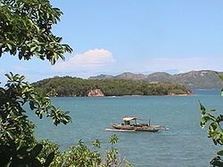
The Concepcion Islands are located east of Panay Island in the Visayan Sea, and are part of the larger Western Visayas archipelago. The islands are part of the town of Concepcion, and comprise 40 percent of Concepcion's total land area. The nearest island is Tago, which is a coral reef 200 metres (660 ft) from the mainland, inside Concepcion Bay. The furthest island is far-flung Baliguian, located 22 kilometres (14 mi) away from the mainland. Baliguian also marks the end of Concepcion's municipal waters. The majority of the islands are mountainous and wooded, ringed by white sand beaches and surrounded by reefs, shoals, and sandbars. A few of the islands feature lighthouses to aid ship navigation in this area.
History
In 1604, Juan Salgado twice defeated Spanish pirates near Pan de Azucar. During World War II, Japanese forces shot down an American fighter pilot, which crash landed near Bag-o Abo Island.
Islands
The Concepcion Islands are: