
Area 21 ha | Highest elevation 220 ft (67 m) Barangay | |
 | ||
Bulubadiangan Island (variously Bolobadiangan island or Bulubadiangan Islet) is a privately owned island in northeastern Iloilo, Philippines. It is part of barangay Polopińa, Concepcion. The Sandbar Island Beach Resort on Bulubadiangan is moderately known within the Philippines.
Contents
- Map of Bulubadiangan Island Concepcion Philippines
- Pavia nhs ssc batch 2005 sandbar beach resort bulubadiangan islands concepcion reunion
- Location and geography
- Places of interest
- References
Map of Bulubadiangan Island, Concepcion, Philippines
Pavia nhs ssc batch 2005 sandbar beach resort bulubadiangan islands concepcion reunion
Location and geography
Bulubadiangan Island is east of Panay Island in the Visayan Sea. Part of the Concepcion Islands, it is a small island off the end of Igbon Island. Bulubadiangan is 220 feet (67 m) at its highest point. Bulubadiangan is 0.5 miles (0.80 km) from Igbon and 2 miles (3.2 km) from Pan de Azucar Island. It is connected to Danao-Danao Island by a small reef. Although privately owned, Bulubadiangan is part of the Polopińa barangay, which has a population of 3,419 according to the 2010 census.
Places of interest
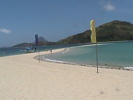
The main feature of Bulubadiangan is its 200-metre (660 ft) sandbar, which is exposed at low tide. The sandbar is a popular destination for tourists visiting Concepcion.