
Length 95.03 km | ||
 | ||
History: 1930s as a highway; 1964 as number | ||
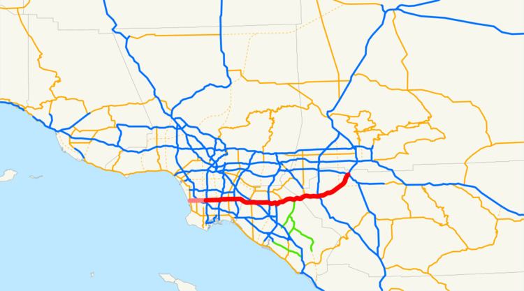
State Route 91 (SR 91) is a major east–west freeway located entirely within Southern California and serving several regions of the Greater Los Angeles metropolitan area. Specifically, it currently runs from Vermont Avenue in Gardena, just west of the junction with the Harbor Freeway (Interstate 110), east to Riverside at the junction with the Pomona (State Route 60 west of SR 91), and Moreno Valley (SR 60 and I-215 east of SR 91) freeways. The route is part of the California Freeway and Expressway System. SR 91 is part of the State Scenic Highway System from SR 55 to the east city limit of Anaheim, in the western part of the Santa Ana Canyon, and is eligible for the system through the canyon to Interstate 15.
Contents
- Map of Artesia Fwy California USA
- Route description
- Gardena Freeway
- Artesia Freeway
- Riverside Freeway
- 91 Express Lanes
- Original US 91 Barstow to Nevada
- SR 18 former extension of US 91 through Santa Ana Canyon to Long Beach
- SR 14 present SR 91 to Hermosa Beach
- Construction of the 91 Express Lanes
- Future
- Exit list
- References
Map of Artesia Fwy, California, USA
SR 91 inherited its route number from the mostly decommissioned US 91, which passed through the Inland Empire in a northeasterly direction on its way to Las Vegas, Salt Lake City, and points beyond. Those segments of US 91 are now parallel to, or have been replaced altogether by, I-15. SR 91 officially used to head west all the way to the Pacific Coast Highway (State Route 1) in Hermosa Beach, but this segment was relinquished to local governments in 2003, and is no longer part of a state highway.
The area from post mile 10.4 to 11.1 is signed as the Juanita Millender-McDonald Highway.
Route description
From the Harbor Freeway to its intersection with the Long Beach Freeway in northern Long Beach, SR 91 is named the Gardena Freeway. Between the Long Beach Freeway and its intersection with the Santa Ana Freeway at the Fullerton-Anaheim border, it is named the Artesia Freeway. From the Santa Ana Freeway to its eastern terminus at the intersection of the Pomona, Moreno Valley, and Escondido Freeways, it is named the Riverside Freeway.
Gardena Freeway
The Gardena Freeway is a short freeway in southern Los Angeles County. It is the westernmost freeway portion of State Route 91. It begins just west of the Harbor Freeway at the intersection with Vermont Avenue in the eastern edge of the city of Gardena, proceeding eastward approximately six miles (10 km) until it intersects the Long Beach Freeway. Thereafter, SR 91 is known as the Artesia Freeway.
Until 1991, the Gardena Freeway was known as the Redondo Beach Freeway. The name change reflected the successful efforts of the cities of Torrance and Redondo Beach to block the extension of the freeway westward to its intended terminus at the cancelled Pacific Coast Freeway in Redondo Beach. In 1997, the California government dedicated the portion of 91 between Alameda Rd and Central Ave to former assemblyman Willard H. Murray Jr.
Artesia Freeway
The Artesia Freeway is a freeway in southeastern Los Angeles County and northwestern Orange County. It is signed as State Route 91 for its entire length. It runs east–west from its western terminus at the Long Beach Freeway in northern Long Beach to its eastern terminus at the Santa Ana Freeway at the Fullerton-Anaheim border. (SR 91 continues west of the Long Beach Freeway as the Gardena Freeway, and east of the Santa Ana Freeway as the Riverside Freeway.) The "Artesia Freeway" name originally was assigned to the entire length of SR 91 west of the Santa Ana Freeway in the early 1970s since it was, in sense, the freeway realignment of SR 91 from the paralleling Artesia Boulevard.
During the 1984 Summer Olympics, a 25 km (16 mi) stretch of the highway was home to the cycling men's road team time trial event.
As the only freeway to link Los Angeles, Orange, and Riverside counties, SR 91 is one of the most heavily congested routes in Southern California.
Riverside Freeway
Between the Santa Ana Freeway, Interstate 5 (I-5), in Buena Park and the 91 Freeway's eastern terminus at a junction with Interstate 215 and State Route 60 in Riverside, the 91 Freeway's assigned name is the Riverside Freeway. Past the I-215/CA-60/CA-91 junction, the Riverside Freeway continues as I-215.
The Riverside Freeway first opened in 1963 signed as U.S. Route 91 and U.S. Route 395 and the last section was built in 1975.
91 Express Lanes
The 91 Express Lanes is a ten-mile (16 km) high-occupancy toll road / full tollway combination contained entirely within the median of the Riverside Freeway (State Route 91) in Orange County, California. They run from the Costa Mesa Freeway (State Route 55) interchange in Anaheim to the Riverside County line.
The 91 Express Lanes consist of two primary lanes in each direction, separated from the regular, main lanes of the Riverside Freeway with reflective yellow, 3' high, plastic lane markers (as opposed to concrete barriers or a similar "solid" barrier). Each direction also has an additional high-occupancy vehicle lane, called the "3+ Carpool Lane", that can only be used by motorcycles, zero emission vehicles, and vehicles with three or more passengers that is equipped with a FasTrak transponder that is assigned to valid prepaid toll account. Access to the 91 Express Lanes are provided only at its east and west ends.
All tolls are collected using an open road tolling system, with each vehicle required to carry a FasTrak transponder; there are no toll booths to receive cash. The 91 Express Lanes use a variable pricing system based on the time of day. The road is not truly "congestion priced" because toll rates come from a preset schedule instead of being based on actual congestion. Since July 1, 2011 the toll on the busiest hour on the tollway, 3:00 pm to 4:00 pm eastbound on Fridays, is $9.75, or approximately $0.97 per mile, the highest toll for any toll road in the country. The highest toll in the morning rush hour, 7:00 am to 8:00 am westbound Monday to Thursday, is $4.60.
Motorcycles and vehicles with three or more passengers who use the "3+" carpool lanes are not charged a toll, except when traveling eastbound from 4:00 pm to 6:00 pm on weekdays. During that period, they are charged 50% of the full posted toll. Even though there may be no toll charge, a FasTrak transponder is still required on all vehicles using the "3+" carpool lanes.
A Toll Policy is published which states the criteria where tolls will be raised. The policy is designed to "a) reduce the likelihood of congestion by diverting traffic to other hours with available capacity; b) maintain free flow travel speed in the 91 Express Lanes; c) maintain travel time savings; d) accommodate projected growth in travel demand and; e) ensure that the toll road generates sufficient revenue to effectively operate the toll lanes and maintain a strong debt service position." Changes to the toll schedule require ten days notification to the public and the OCTA board. Once tolls are changed during the "super peak" period, they may not be changed again for six months. All tolls increase annually due to inflation. Despite this, the toll lanes are generally free flowing during most peak hour conditions.
Original US 91 - Barstow to Nevada
The Arrowhead Trail, an auto trail connecting Salt Lake City with Los Angeles, initially took a longer route via present US 95 and former US 66 between Las Vegas and Needles, as the more direct Old Spanish Trail was in very poor condition. The "Silver Lake cutoff", which would save about 90 miles (145 km), was proposed by 1920, and completed in 1925 as an oiled road by San Bernardino County. The Bureau of Public Roads and the state of Nevada both urged its inclusion in the state highway system, the former as part of the federal aid highway connecting Salt Lake City and Los Angeles, and the state legislature did that in 1925, with it becoming an extension of Route 31. (Across the state line, State Route 6 continued through Las Vegas to Arizona.) The initial plan for the U.S. Highway system simply stated that Route No. 91 would run from Las Vegas "to an intersection with Route No. 60" (which became US 66 in 1926), but in 1926 the cutoff was chosen, ending at US 66 at Daggett, just east of Barstow. (The roadway south from Las Vegas later became part of US 95.) The route was added to the federal-aid secondary system in 1926, which helped pay for a mid-1930s widening and paving, including some realignments (parts of the old road are now known as Arrowhead Trail). The new routing generally followed the present I-15, except through Baker (where it used Baker Boulevard) and into Barstow (where it followed former SR 58 to First Avenue, ending at Main Street, which carried US 66).
SR 18 - former extension of US 91 through Santa Ana Canyon to Long Beach
US 91 was extended southwest to Long Beach in the late 1940s. Beginning at Barstow, the extension overlapped US 66 over Cajon Pass to San Bernardino. From San Bernardino west through Riverside and Santa Ana Canyon to Olive, the state took over a mostly-paved county highway in 1931 as part of an extension of Route 43 to Newport Beach via Santa Ana. Two branches leading west from Route 43 near Olive along mostly-constructed county roads were added in 1933: Route 175 along Orangethorpe Avenue and Artesia Boulevard from near the mouth of the canyon west to Route 60 (now SR 1) in Hermosa Beach (unconstructed through Compton until the mid-1950s), and Route 178 along Lincoln Avenue and Carson Street from Olive west to Route 168 (now SR 19) in Lakewood. When state routes were marked in 1934, Route 175 became Sign Route 14, and Sign Route 18 included all of Route 178 and most of Route 43 into the San Bernardino Mountains. When US 91 was extended to Long Beach, it overlapped SR 18 from San Bernardino to Lakewood, where it turned south along SR 19 to the Los Alamitos Traffic Circle. There it turned west along US 101 Alternate to near downtown Long Beach, where it ended at SR 15 (Atlantic Avenue), at a terminus shared with US 6. (This routing along SR 19 and US 101 Alt. also became an extension of SR 18.)
In 1935, the state improved the alignment between Fairmont Boulevard and Gypsum Canyon Road, including a bypass of the old road, which curved along the south slope of the canyon, east of Weir Canyon Road. In the late 1930s, the Prado Dam project resulted in the bypassing of a longer section, replacing Prado Road, an abandoned road curving to the east end of the dam, Pomona Rincon Road, Auto Center Drive, Pomona Road, and Yorba Street with the present Green River Road, Palisades Drive, part of SR 91, and 6th Street.
SR 14 - present SR 91 to Hermosa Beach
Before the present freeway was constructed, SR 14 ran along Gould Avenue, Redondo Beach Boulevard, Compton Boulevard, Alameda Street, Artesia Avenue, La Habra Road, Firestone Boulevard and Orangethorpe Avenue. In the 1964 renumbering, SR 14 was renumbered to SR 91.
Prior to 1991, the Gardena Freeway was known as the Redondo Beach Freeway, referring to Caltrans's original intention for the freeway portion of the route to continue all the way to the never-built Pacific Coast Freeway.
Also, before 1997, SR 91 continued all the way to State Route 1 in Hermosa Beach. At that time, the route became discontinuous in Gardena, the portion between Vermont Avenue and Western Avenue being turned over to the city. In 2003, the western portion, from SR 1 to Western Ave. was relinquished to the local jurisdictions. The first segment of the freeway was made in 1965 signed as US 91, and the last segment was made in 1975. However, Artesia Blvd. from I-405 to SR 1 is still marked as SR 91 to this day.
Construction of the 91 Express Lanes
Due to rapid population growth and the decline in the availability of affordable housing closer to job centers in Orange County, new residential development began in earnest in western Riverside County (consistent with similar accelerated growth throughout the Inland Empire) from the 1980s through today. This new development is occurring in or around existing cities such as Riverside, Corona, Norco, Moreno Valley, Lake Elsinore, and Temecula. This new development has also created new incorporated cities such as Menifee, Eastvale, and Jurupa Valley.
As there are very few direct routes between Orange and Riverside Counties because of the Santa Ana Mountains that separate the two counties, the Riverside Freeway is subject to a very heavy traffic volume, composed primarily of commuters traveling between where they work in Orange County and where they live in Riverside County (often referred to by traffic reporters as "The Corona Crawl") Typical peak period delays were 30–40 minutes in each direction in the ten miles (16 km) of the tollway before construction.
Solutions to the traffic problem were limited. The chosen solution was to create a toll road in the median of the freeway. The toll road route operates between the Orange/Riverside county line and the Costa Mesa Freeway (SR 55) interchange in eastern Anaheim, a distance of about 10 miles (16 km). The project was developed in partnership with the California Department of Transportation (Caltrans) by California Private Transportation Company (CPTC), which formally transferred ownership of the facility to the State of California prior to opening the project to traffic on December 27, 1995. Caltrans then leased the toll road back to CPTC for a 35-year operating period. The new lanes have been officially designated a part of the state highway system. The California Highway Patrol (CHP) is responsible for providing police services at CPTC's expense. Maintenance and operational costs for the facility are also the responsibility of CPTC.
In April, 2002, the Orange County Transportation Authority (OCTA) reached an agreement in concept to purchase the private toll road project for $207.5 million. The OCTA took possession of the Toll Road on January 3, 2003, marking the first time the 91 Express Lanes was managed by public officials. Within a few months, OCTA turned the lanes into the HOT / tollway hybrid that it is today. One of the primary investors in CPTC, Cofiroute USA, continues to manage and operate the lanes under a management contract with OCTA.
Opening in 1995, the 91 Express Lanes is the first privately funded tollway built in the United States since the 1940s, and the first fully automated tollway in the world.
The express lanes have been controversial because of a "non-compete" agreement that the state made with CPTC. The clause, which was negotiated by Caltrans and never was brought to the legislature, prevent any improvements along 30 miles (48 km) of the Riverside Freeway to ensure profit for the express lanes. This includes restricting the state from widening the free lanes or building mass transit near the freeway. CPTC filed a lawsuit against Caltrans over freeway widening related to the interchange with the Eastern Transportation Corridor interchange, which was dismissed once the purchase with OCTA was finalized. Following the settlement, an additional lane was added for a 5-mile segment eastbound from SR-241 to SR-71, which has decreased usage of the toll road and revenues.
However, as a result of the controversy, more toll road advocates favor creating local agencies similar to Transportation Corridor Agencies to build and maintain future tollways. New toll roads would be financed with tax-exempt bonds on a stand-alone basis—taxpayers would not be responsible for repaying any debt if toll revenues fall short. Also, there would be a less restrictive "non-compete" clause: they would be compensated only for any revenue loss caused by improvements near the toll roads.
Future
In 2005, evaluations were made about the feasibility of constructing two tunnels through the Santa Ana Mountains which could carry 72,000 cars per day and allow for a commuter rail service between Corona and Irvine. The financial and technical evaluations found that in the current financial environment, building the tunnels would not be financially or technologically feasible. Additional study of the Irvine Corona Expressway tunnel project has been deferred until such time as financial considerations improve and/or technological advancements warrant reexamination. If built, the Irvine-Corona Expressway would follow a similar route to the 91 Freeway and is designed to reduce the growing traffic congestion on SR 91 that prompted the construction of the 91 Express Lanes. If completed, the Irvine-Corona Expressway is projected to be the longest traffic tunnel in North America, approximately 11.5 miles. One tunnel would be a reversible two lane freeway for autos and trucks, the direction reversed based on time of day. It would carry westbound traffic in the morning hours, and eastbound traffic during the afternoon/ early evening hours. The second tunnel would be slated exclusively for light rail commuter train service. The proposed tunnels are opposed by environmental groups, cities in Orange County near the terminus of the proposed road, and by the Irvine Company, which believes that the tunnel is not necessary and distracts from short term solutions such as freeway widening.
The Riverside County Transportation Commission plans to extend the 91 Express Lanes east from its current eastern terminus at the Orange-Riverside county line to the I-15 interchange in Corona; scheduled completion date for this project is 2017. Once completed, both Orange and Riverside County transportation agencies will co-manage the 91 Express Lanes.
Numerous other projects by the Orange County Transportation Authority are currently underway or in the planning phases for distant completion, some as far out as the year 2030.
Exit list
Except where prefixed with a letter, postmiles were measured on the road as it was in 1964, based on the alignment that existed at the time, and do not necessarily reflect current mileage. R reflects a realignment in the route since then, M indicates a second realignment, L refers an overlap due to a correction or change, and T indicates postmiles classified as temporary (for a full list of prefixes, see the list of postmile definitions). Segments that remain unconstructed or have been relinquished to local control may be omitted. The numbers reset at county lines; the start and end postmiles in each county are given in the county column.