
Incorporated May 9, 1893 Population 2.293 million (2013) | Area 18,915 km² Unemployment rate 6.2% (Apr 2015) | |
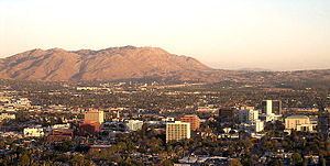 | ||
Country United States of America Points of interest Castle Park, The Mission Inn Hotel & Spa Colleges and Universities University of California, Riverside City College, Mt San Jacinto College, California Baptist University, College of the Desert Destinations | ||
Blm shooting area near lake elsinore riverside county california
Riverside County, California is one of fifty-eight counties in the U.S. state of California. As of the 2010 census, the population was 2,189,641, making it the 4th-most populous county in California and the 11th-most populous in the United States. The name was derived from the city of Riverside, which is the county seat.
Contents
- Blm shooting area near lake elsinore riverside county california
- Map of Riverside County CA USA
- Early history
- County history
- Geography
- Flora and fauna
- National protected areas
- State parks
- County parks and trails
- 2010
- 2000
- Government
- Law
- Overview
- Crime
- Universities and colleges
- Public transportation
- Military air bases
- Commercial airports
- Military installations
- Points of interest
- Indian reservations
- Population ranking
- References
Map of Riverside County, CA, USA
Riverside County is included in the Riverside-San Bernardino-Ontario, CA Metropolitan Statistical Area, also known as the Inland Empire. The county is also included in the Los Angeles-Long Beach, CA Combined Statistical Area. There is a high concentration of sprawling tract housing communities around Riverside and along the Interstate 10, 15, and 215 freeways.
Roughly rectangle-shaped, Riverside County covers 7,208 square miles (18,670 km2) in Southern California, spanning from the Greater Los Angeles area to the Arizona border. Geographically, the county is mostly desert in the central and eastern portions, but has a Mediterranean climate in the western portion. Most of Joshua Tree National Park is located in the county.
The resort cities of Palm Springs, Palm Desert, Indian Wells, La Quinta, Rancho Mirage, and Desert Hot Springs are all located in the Coachella Valley region of Riverside County. Large numbers of Los Angeles area workers have moved to the county in recent years (data from the US Census Bureau for 2007 through 2011) to take advantage of relatively affordable housing. Along with neighboring San Bernardino County, it was one of the fastest growing regions in the state prior to the recent changes in the regional economy. In addition, smaller, but significant, numbers of people have been moving into Southwest Riverside County from the San Diego-Tijuana metropolitan area. The cities of Temecula and Murrieta accounted for 20% of the increase in population of the county between 2000 and 2007.
Early history
The indigenous peoples of what is now Riverside County are the Luiseño, Cupeño and Cahuilla Indians. The Luiseño lived in the Aguanga and Temecula Basins, Elsinore Trough and eastern Santa Ana Mountains and southward into San Diego County. The Cahullia lived to the east and north of the Luiseño in the inland valleys, Santa Rosa and San Jacinto Mountains and the desert of the Salton Sink.
The first European settlement in the county was a Mission San Luis Rey de Francia estancia or farm, at the Luiseño village of Temecula. Grain and grapes were grown here. In 1819, the Mission granted land to Leandro Serrano, mayordomo of San Antonio de Pala Asistencia for the Mission of San Luis Rey for Rancho Temescal.
Following Mexican independence and the 1833 confiscation of Mission lands, more ranchos were granted. Rancho Jurupa in 1838, El Rincon in 1839, Rancho San Jacinto Viejo in 1842, Rancho San Jacinto y San Gorgonio in 1843, Ranchos La Laguna, Pauba, Temecula in 1844, Ranchos Little Temecula, Potreros de San Juan Capistrano in 1845, Ranchos San Jacinto Sobrante, La Sierra (Sepulveda), La Sierra (Yorba), Santa Rosa and San Jacinto Nuevo y Potrero in 1846.
New Mexican colonists founded the town of La Placita on the east side of the Santa Ana River at the northern extremity of what is now the city of Riverside in 1843.
When the initial 27 California counties were established in 1850 the area today known as Riverside County was divided between Los Angeles County and San Diego County. In 1853 the eastern part of Los Angeles County was used to create San Bernardino County. Between 1891 and 1893 several proposals, and legislative attempts, were put forth to form new counties in Southern California. These proposals included one for a Pomona County and one for a San Jacinto County. None of the proposals were adopted until a measure to create Riverside County was signed by Governor Henry H. Markham on March 11, 1893.
County history
The new county was created from parts of San Bernardino County and San Diego County. On May 2, 1893, seventy percent of voters approved the formation of Riverside County. Voters chose the city of Riverside as the county seat, also by a large margin. Riverside County was officially formed on May 9, 1893, when the Board of Commissioners filed the final canvass of the votes.
Riverside County is the birthplace of lane markings, thanks to Dr. June McCarroll in 1915 when she suggested her idea to the state government.
The county is also the location of the March Air Reserve Base, one of the oldest airfields continuously operated by the United States military. Established as the Alessandro Flying Training Field in February 1918, it was one of thirty-two U.S. Army Air Service training camps established after the United States entry into World War I in April 1917. The airfield was renamed March Field the following month for 2d Lieutenant Peyton C. March, Jr., the recently deceased son of then-Army Chief of Staff, General Peyton C. March, who was killed in an air crash in Texas just fifteen days after being commissioned. March Field remained an active Army Air Service, then U.S. Army Air Corps installation throughout the interwar period, later becoming a major installation of the U.S. Army Air Forces during World War II. Renamed March Air Force Base in 1947 following the establishment of the U.S. Air Force, it was a major Strategic Air Command (SAC) installation throughout the Cold War. In 1996, it was transferred to the Air Force Reserve Command and gained its current name as a major base for the Air Force Reserve and the California Air National Guard.
Riverside county was a major focal point of the Civil Rights Movements in the USA, especially the African-American sections of Riverside and heavily Mexican-American communities of the Coachella Valley visited by Cesar Chavez of the farm labor union struggle.
Riverside county has also been a focus of modern Native American Gaming enterprises. In the early 1980s, the county government attempted to shut down small bingo halls operated by the Morongo Band of Cahuilla Mission Indians and the Cabazon Band of Mission Indians. The tribes joined forces and fought the county all the way to the U.S. Supreme Court, which ruled in the tribes' favor on February 25, 1987. In turn, Congress enacted the Indian Gaming Regulatory Act in 1988 to establish a legal framework for the relationship between Indian gaming and state governments. Naturally, both tribes now operate large casinos in the county: the Morongo Casino, Resort & Spa and the Fantasy Springs Resort Casino adjacent to Spotlight 29 Casino.
The county's population surpassed one million people in 1980 when the current trend of high population growth as a major real estate destination began in the 1970s. Once strictly a place for long distance commuters to L.A. and later Orange County, the county and city of Riverside has become more of a place to establish new or relocated offices, corporations and finance centers in the late 1990s and 2000s. More light industry, manufacturing and truck distribution centers became major regional employers in the county.
Geography
According to the U.S. Census Bureau, the county has a total area of 7,303 square miles (18,910 km2), of which 7,206 square miles (18,660 km2) is land and 97 square miles (250 km2) (1.3%) is water. It is the fourth-largest county in California by area. At roughly 180 miles (290 km) wide in the east-west dimension, the area of the county is massive. Riverside County, California is roughly the size of the State of New Jersey in total area. County government documents frequently cite the Colorado River town of Blythe as being a "three-hour drive" from the county seat, Riverside. Some view the areas west of San Gorgonio Pass as the Inland Empire portion of the county and the eastern part as either the Mojave Desert or Colorado Desert portion. There are probably at least three geomorphic provinces: the Inland Empire western portion, the Santa Rosa Mountains communities such as Reinhardt Canyon, and the desert region. Other possible subdivisions include tribal lands, the Colorado River communities, and the Salton Sea.
Flora and fauna
There is a diversity of flora and fauna within Riverside County. Vegetative plant associations feature many desert flora, but there are also forested areas within the county. The California endemic Blue oak, Quercus douglasii is at the southernmost part of it its range in Riverside County.
National protected areas
There are 19 official wilderness areas in Riverside County that are part of the National Wilderness Preservation System. Some are integral parts the above protected areas, most (11 of the 19) are managed solely by the Bureau of Land Management, and some share management between the BLM and the relevant other agencies. Some extend into neighboring counties:
State parks
County parks and trails
2010
The 2010 United States Census reported that Riverside County had a population of 2,189,641. The racial makeup of Riverside County was 1,335,147 (61.0%) White (40.7% Non-Hispanic White), 140,543 (6.4%) African American, 23,710 (1.1%) Native American, 130,468 (6.0%) Asian (2.3% Filipino, 0.8% Chinese, 0.7% Vietnamese, 0.6% Korean, 0.5% Indian, 0.2% Japanese, 0.1% Cambodian, 0.1% Laotian, 0.1% Pakistani), 6,874 (0.3%) Pacific Islander, 448,235 (20.5%) from other races, and 104,664 (4.8%) from two or more races. Hispanic or Latino of any race were 995,257 persons (45.5%); 39.5% of Riverside County is Mexican, 0.8% Salvadoran, 0.7% Honduran, 0.6% Puerto Rican, 0.3% Cuban, and 0.2% Nicaraguan.
2000
As of the census of 2000, there were 1,545,387 people, 506,218 households, and 372,576 families residing in the county. The population density was 214 people per square mile (83/km²). There were 584,674 housing units at an average density of 81 per square mile (31/km²). The racial makeup of the county was 65.6% White, 6.2% Black or African American, 1.2% Native American, 3.7% Asian, 0.3% Pacific Islander, 18.7% from other races, and 4.4% from two or more races. 36.2% of the population were Hispanic or Latino of any race. 9.2% were of German, 6.9% English, 6.1% Irish and 5.0% American ancestry according to Census 2000. 67.2% spoke English and 27.7% Spanish as their first language.
In 2006 the county had a population of 2,026,803, up 31.2% since 2000. In 2005 45.8% of the population was non-Hispanic whites. The percentages of African Americans, Asians and Native Americans remained relatively similar to their 2000 figures. The percentage of Pacific Islanders had majorly risen to 0.4. Hispanics now constituted 41% of the population.
There were 506,218 households out of which 38.90% had children under the age of 18 living with them, 56.5% were married couples living together, 12.0% had a female householder with no husband present, and 26.4% were non-families. 20.7% of all households were made up of individuals and 9.3% had someone living alone who was 65 years of age or older. The average household size was 3.0 and the average family size was 3.5.
In the county, the population was spread out with 30.3% under the age of 18, 9.2% from 18 to 24, 28.9% from 25 to 44, 18.9% from 45 to 64, and 12.7% who were 65 years of age or older. The median age was 33 years. For every 100 females there were 99.1 males. For every 100 females age 18 and over, there were 96.8 males.
The median income for a household in the county was $42,887, and the median income for a family was $48,409. Males had a median income of $38,639 versus $28,032 for females. The per capita income for the county was $18,689. About 10.7% of families and 14.2% of the population were below the poverty line, including 18.5% of those under age 18 and 7.6% of those age 65 or over.
Government
Riverside County is organized as a General Law County under the provision of the California Government Code. The county has five supervisorial districts, and one supervisor is elected from each district every four years.
In 1999, the County Board of Supervisors approved a multi-million dollar planning effort to create thr Riversid County Integrated Plan (RCIP) which was to encompass a completely new General Plan, regional transportation plan (CETAP) and Habitat Conservation Plan. The resultant General Plan adopted in 2003 was considered ground-breaking for it's multi-disciplinary approach to land use and conservation planning.
Law
The Riverside Superior Court is the state trial court for Riverside County with 14 courthouses: Riverside Historic Courthouse, Riverside Hall of Justice, Riverside Family Law Court, Riverside Juvenile Court, Southwest Justice Center – Murrieta, Moreno Valley Court, Banning Court, Hemet Court, Corona Court, Temecula Court, Larson Justice Center – Indio, Indio Juvenile Court, Palm Springs Court and Blythe Court.
The main courthouse is the Riverside Historic Courthouse. This landmark, erected in 1903, was modeled after the Grand and Petit Palais in Paris, France. The courthouse, designed by Los Angeles architects Burnham and Bliesner, has a classical design – including a great hall that connects all the departments (courtrooms). In 1994, the courthouse was closed for seismic retrofits due to the 1992 Landers and 1994 Northridge earthquakes. The courthouse was reopened and rededicated in September 1998.
Riverside County hands down 1 in 6 death sentences in the USA, in spite of it having less than 1% of the population.
Overview
Riverside has historically been regarded as a Republican county in presidential and congressional elections. In 1932, it was one of only two counties (the other being Benton County, Oregon) on the entire Pacific coast of the United States to vote for Hoover over Roosevelt. In 2008, Barack Obama narrowly carried the county, becoming the first Democrat to do so since Bill Clinton in 1992. In 2012, Obama again carried the county, this time with a plurality of the vote.
In the United States House of Representatives, Riverside County is split between 4 congressional districts:
In the California State Senate, the county is split between 3 legislative districts:
In the California State Assembly, the county is split between 7 legislative districts:
Riverside County voted 64.8% in favor of Proposition 8 which amended the California Constitution to ban same-sex marriages.
Crime
The following table includes the number of incidents reported and the rate per 1,000 persons for each type of offense.
Universities and colleges
Public transportation
Riverside County is also served by Greyhound buses. Amtrak trains stop in Riverside and Palm Springs, and Amtrak California provides bus connections to the San Joaquins in Riverside, Beaumont, Palm Springs, Thousand Palms, Indio, Moreno Valley, Perris, Sun City and Hemet. Metrolink trains serve five stations in Riverside County: Riverside-Downtown, Riverside-La Sierra, North Main-Corona, West Corona, and Pedley Station (in the community of Pedley, California). These trains provide service to Orange, San Bernardino and Los Angeles counties seven days a week, with a primarily commuter-oriented schedule.
In the late 2000s, local transportation options expanded, such as the addition of new railroad stations in Perris, California to connect travelers and commuters to or from southwest Riverside county, as well the Perris station serves the MetroLink mass transit train service in Corona, California.
Military air bases
Commercial airports
Military installations
Points of interest
Indian reservations
Riverside County has 12 federally recognized Indian reservations, which ties it with Sandoval County, New Mexico for second most of any county in the United States. (Sandoval County, however, has two additional joint-use areas, shared between reservations. San Diego County, California has the most, with 18 reservations.)
Population ranking
The population ranking of the following table is based on the 2010 census of Riverside County.
† county seat