
- location below Lake Somerset Basin area 1,535 km² Basin area 1,330 km² | - elevation 216 m (709 ft) - elevation 64 m (210 ft) Length 35 km | |
 | ||
- left Neurem Creek, Stony Creek (Queensland), Blackrock Creek, Oaky Creek (Queensland), Reedy Creek (Queensland) - right London Creek, Scrubby Creek, Sandy Creek (Queensland), Kilcoy Creek | ||
The Stanley River is a perennial river located in the South East region of Queensland, Australia. A major tributary of the Brisbane River, the Stanley River valley extends roughly 35 kilometres (22 mi) westwards from the area south of Maleny, through Woodford to Kilcoy before veering southwards.
Contents
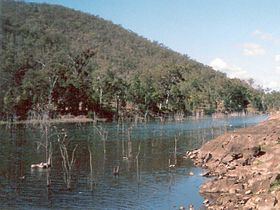
Map of Stanley River, Royston QLD, Australia
Course and features
Formed by runoff from the Jimna, Conondale, Bellthorpe and D'Aguilar ranges, the river rises west of Landsborough in the hinterland surrounding the Sunshine Coast and flows generally southwest, joined by eighteen minor tributaries before being impounded by the Somerset Dam built 7 kilometres (4.3 mi) upstream from its confluence with the Brisbane River. The dam was the principal water supply for Brisbane for some fifty years until the construction of the Wivenhoe Dam was completed, forming Lake Wivenhoe. The Stanley River tributaries include Ewen, Crohamhurst, London, Running, Blackrock, One Mile, Monkeybong, Delaney’s, Neurem, Stony, Marysmokes, Scrubby, Sandy, Kilcoy, Sheepstation, Oaky, Byron and Reedy Creeks.
The river courses through one of the heaviest rainfall areas in Australia. The average annual rainfall in the area is 925 millimetres (36.4 in).
Riparian vegetation around the Lake Somerset area have been almost completely cleared for grazing. In the upper reaches bushland remains mostly intact although wildlife corridors have been fragmented and fish stocks reduced.
The Gastric-brooding frog is an extinct frog that was discovered in only three catchments, the Mary River, Mooloolah and Stanley Rivers. The Endangered Giant Barred Frog Mixophyes iteratu has also been recorded on the Stanley River.
History
Before either dam was built the Stanley and Brisbane Rivers were both prone to flooding. Despite warnings instigated by Henry Somerset who saw flash flooding in the upper reaches of the Stanley River valley, the 1893 Black February floods caused severe flooding downstream in Brisbane and other towns such as Fernvale. The 1893 floods occurred after heavy rains near Peachester.
The river once marked the north-west boundary of the defunct County of Stanley.