Trisha Shetty (Editor)

Blue Ridge Parkway

Updated on
Edit
Like
Comment
Share on FacebookTweet on TwitterShare on LinkedInShare on Reddit
Established
  
June 30, 1936

Governing body
  
National Park Service

Founded
  
30 June 1936

Management
  
National Park Service

Visitors
  
12,877,368 (in 2013)

Length
  
754.8 km

Constructed
  
30 June 1936

Nearest cities
  
Asheville, Virginia

Blue Ridge Parkway

Location
  
North Carolina & Virginia, USA

Nearest city
  
Asheville, NC & Roanoke, VA

Area
  
93,390 acres (377.9 km)

Similar
  
Blue Ridge Mountains, Pisgah National Forest, Shenandoah National Park, Great Smoky Mountain, Grandfather Mountain

Blue ridge parkway 3 minute tour


The Blue Ridge Parkway is a National Parkway and All-American Road in the United States, noted for its scenic beauty. The parkway, which is America's longest linear park, runs for 469 miles (755 km) through 29 Virginia and North Carolina counties, mostly along the Blue Ridge, a major mountain chain that is part of the Appalachian Mountains. Its southern terminus is on the boundary between Great Smoky Mountains National Park and the Cherokee Indian Reservation in North Carolina, from which it travels north to Shenandoah National Park in Virginia and offers access to the Skyline Drive. While the two roads join together end-to-end, they are separate and distinct entities, built as two different projects and managed by two different National Park Service units. The Blue Ridge Parkway was built to connect Shenandoah National Park to the Great Smoky Mountains National Park.

Contents

Map of Blue Ridge Pkwy, United States

The parkway, while not a National Park, has been the most visited unit of the National Park System every year since 1946 except two (1949, 2013). Land on either side of the road is owned and maintained by the National Park Service and, in many places, parkway land is bordered by United States Forest Service property. The parkway is on North Carolina's version of the America the Beautiful quarter in 2015.

The explorers of the blue ridge parkway discovering america s favorite drive in asheville n c


History

Begun during the administration of President Franklin D. Roosevelt, the project was originally called the Appalachian Scenic Highway. Most construction was carried out by private contractors under federal contracts under an authorization by Harold L. Ickes in his role as federal public works administrator. Work began on September 11, 1935, near Cumberland Knob in North Carolina; construction in Virginia began the following February. On June 30, 1936, Congress formally authorized the project as the Blue Ridge Parkway and placed it under the jurisdiction of the National Park Service. Some work was carried out by various New Deal public works agencies. The Works Progress Administration did some roadway construction. Crews from the Emergency Relief Administration carried out landscape work and development of parkway recreation areas. Personnel from four Civilian Conservation Corps camps worked on roadside cleanup, roadside plantings, grading slopes, and improving adjacent fields and forest lands. During World War II, the CCC crews were replaced by conscientious objectors in the Civilian Public Service program.

The parkway's construction created jobs in the region, but also displaced many residents and created new rules and regulations for landowners, including requirements related to how farmers could transport crops. Residents could no longer build on their lands without permission or develop land except for agricultural use. They were not permitted to use the parkway for any commercial travel but were required to transport equipment and materials on side roads.

The Eastern Band of Cherokee Indians were also affected by the parkway, which was built through their lands. From 1935 to 1940, they resisted giving up the right-of-way through the Qualla Boundary, and they were successful in gaining more favorable terms from the U.S. government. Specifically, the revised bill "specified the parkway route, assured the $40,000 payment for the tribe's land, and required the state to build [a] regular highway through the Soco Valley" (the highway referred to is part of U.S. Route 19, US 19). Cherokee leaders participated in the dedications when the Cherokee sections opened in the 1950s.

Construction of the parkway was complete by the end of 1966 with one notable exception. The 7.7 miles (12.4 km) stretch including the Linn Cove Viaduct around Grandfather Mountain did not open until 1987. The project took over 52 years to complete.

Ecology along the parkway

Flowering shrubs and wildflowers dominate the parkway in the spring, including rhododendrons and dogwoods, moving from valleys to mountains as the cold weather retreats. Smaller annuals and perennials such as the daisy and aster flower through the summer. Brilliant autumn foliage occurs later in September on the mountaintops, descending to the valleys by later in October. Often in early-to-middle October and middle to late April, all three seasons can be seen simply by looking down from the cold and windy parkway to the green and warm valleys below. October is especially dramatic, as the colored leaves stand out boldly and occur mostly at the same time, unlike the flowers.

Major trees include oak, hickory, and tulip tree at lower elevations and buckeye and ash in the middle, turning into conifers such as fir and spruce at the highest elevations on the parkway. Trees near ridges, peaks, and passes (often called gaps or notches) are often distorted and even contorted by the wind, and persistent rime ice deposited by passing clouds in the winter.
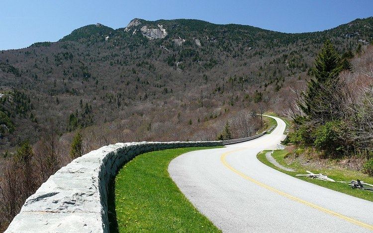
Route description

The Blue Ridge Parkway tunnels were constructed through the rockā€”one in Virginia and twenty-five in North Carolina. Sections of the parkway near the tunnels are often closed in winter. (Due to dripping groundwater from above, freezing temperatures, and the lack of sunlight, ice often accumulates inside these areas even when the surrounding areas are above freezing.) The highest point on the parkway (south of Waynesville, near Mount Pisgah in North Carolina) is 6053 feet or 1845 m above sea level (AMSL) on Richland Balsam Mountain at Milepost 431, and is often closed from November to April due to inclement weather such as snow, fog, and even freezing fog from low clouds. The parkway is carried across streams, railway ravines and cross roads by 168 bridges and six viaducts.

The parkway runs from the southern terminus of Shenandoah National Park's Skyline Drive in Virginia at Rockfish Gap to U.S. Route 441 at Oconaluftee in the Great Smoky Mountains National Park near Cherokee, North Carolina. There is no fee for using the parkway; however, commercial vehicles are prohibited without approval from the Park Service Headquarters, near Asheville, North Carolina. The roadway is not maintained in the winter, and sections which pass over especially high elevations and through tunnels are often impassable and therefore closed from late fall through early spring. Weather is extremely variable in the mountains, so conditions and closures often change rapidly. The speed limit is never higher than 45 mph (72 km/h) and lower in some sections.

The parkway uses short side roads to connect to other highways, and there are no direct interchanges with Interstate Highways (though current plans for Interstate 73 take it along current US 220 at its parkway interchange), making it possible to enjoy wildlife and other scenery without stopping for cross-traffic. Mileposts along the parkway start at zero at the northeast end in Virginia and count to 469 at the southern end in North Carolina. The mileposts can be found on the right-hand side of the road while traveling southbound on the parkway. Major towns and cities along the way include Waynesboro, Roanoke, and Galax in Virginia; and in North Carolina, Boone and Asheville, where it runs across the property of the Biltmore Estate. The Blue Ridge Music Center (also part of the park) is located in Galax, and Mount Mitchell (the highest point in eastern North America) is only accessible via a state highway (NC 128) from the parkway at milepost 355.4.

Highlights in Virginia

  • Mile 0 Rockfish Gap near Waynesboro, Virginia, is the northern end of the Blue Ridge Parkway. To the north the parkway connects directly to Skyline Drive, which winds 105 miles (169 km) through Shenandoah National Park.
  • 5 to 9.3 Humpback Rock has a self-guiding trail through a collection of old Appalachian farm buildings. A hiking trail from the parking area (at mile 6.1) leads 0.75-mile (1.21 km) to The Rocks, whose humped appearance gives the area its name. Greenstone self-guiding trail (8.8).
  • 10.7 Ravens Roost offers vistas of Torry Mountain and the Shenandoah Valley to the west. The overlook is built above a cliff, so it is frequently used for rock-climbing and hang-gliding. There is also a single picnic table.
  • 16 Sherando Lake is a recreation area in George Washington National Forest 4.5 miles (7.2 km) from the parkway via VA.814. Swimming, picnicking, and camping.
  • 29 Whetstone Ridge provided many a mountain man with a fine-grained sharpening stone.
  • 34.4 Yankee Horse Ridge supposedly is where a hard-riding Union soldier's horse fell and had to be shot. A reconstructed spur of an old logging railroad provides access to Wigwam Falls.
  • 58 to 63.6 Otter Creek runs 10 miles (16 km) down the Blue Ridge to the James River. Otter Lake (63.1), fishing, trail.
  • 63.8 The James River and Kanawha Canal is where a footbridge leads across the river to the restored canal locks and exhibits. A self-guiding trail follows the river bluff.
  • 71 Onion Mountain's short loop trail leads through rhododendron and mountain laurel.
  • 83.4 Fallingwater Cascades can be seen along a 1.6-mile (2.6 km) loop trail.
  • 84 to 87 Peaks of Otter are three mountain peaks which have been popular viewing sites since the days of Thomas Jefferson. A shuttle bus provides service to Sharp Top.
  • 114.9 Roanoke River Gorge is visible after a short walk.
  • 120.4 Roanoke Mountain is a 3.7-mile (6.0 km) side trip. A one-way loop road, with steep grades, crosses over the mountain. Towed vehicles are prohibited.
  • 129.6 Roanoke Valley Overlook gives a view of the largest community along the parkway.
  • 154.5 Smart View is named for having "a right smart view." A nearby cabin built in the 1890s is known as a spot for viewing dogwood blooms in early May.
  • 167 to 174 Rocky Knob overlooks Rock Castle Gorge.
  • 176.1 Mabry Mill was operated by E.B. Mabry from 1910 to 1935. A trail leads to his gristmill, sawmill, blacksmith shop, and other exhibits. Old-time skills are demonstrated in the summer and fall.
  • 188.8 Groundhog Mountain has a variety of rural fences: snake, Post-and-rail, picket and buck. Picnic grounds and observation tower are also nearby.
  • 189.1 Groundhog Mountain
  • 189.9 Aunt Orelena Puckett Cabin Exhibit was the home of an area midwife.
  • 213 Blue Ridge Music Center near the town of Galax with concerts, music demonstrations, and a 17,000-square-foot (1,600 m2) museum dedicated to anything musical, especially old time music.
  • Highlights in North Carolina

    The Blue Ridge Parkway crosses the North Carolina-Virginia state line at mile 216.9. The 1749 party that surveyed the boundary included Peter Jefferson, father of Thomas Jefferson.

  • Mile 217.5 Cumberland Knob, at 2,885 feet (879 m), is the center piece of a small parkway recreation area.
  • 218.6 Fox Hunters Paradise, down a short walking path, is where hunters could listen to their hounds baying in the valley below.
  • 238.5 Brinegar Cabin was built by Martin Brinegar about 1880 and lived in until the 1930s when the homestead was purchased from his widow for the parkway. The original cabin stands there today.
  • 238.5 to 244.7 Doughton Park was named for Congressman Robert L. Doughton, a staunch supporter and neighbor of the parkway. The park has many miles of hiking trails, a lodge, dinner, picnic area and a campground.
  • 258.6 Northwest Trading Post offers crafts from North Carolina's northwestern counties.
  • 260.6 Jumpinoff Rock is at the end of a short woodland trail.
  • 264.4 The Lump is a grassy knob that provides views of the forested foothills.
  • 272 E. B. Jeffress Park has a self-guided trail to a waterfall known as the Cascades. Another trail goes to an old cabin and church.
  • 285.1 Daniel Boone's Trace, which Boone blazed to the West, crosses near here.
  • 292 to 295 Moses H. Cone Memorial Park has hiking, fishing and horse trails. Flat Top Manor, the former house of Moses H. Cone, is now used as the Parkway Craft Center.
  • 295.1 to 298 Julian Price Memorial Park, the former retreat of the insurance executive Julian Price, offers a variety of hiking trails, campground, and a 47-acre (190,000 m2) Price Lake. This is the only lake on the parkway on which paddling is allowed.
  • 304.4 Linn Cove Viaduct, the last segment of the parkway built, skirts the side of Grandfather Mountain. A visitor center is located nearby and provides access to a trail under the viaduct.
  • 308.3 Flat Rock provides views of Grandfather Mountain and Linville Valley.
  • 316.3 Linville Falls Recreation Area provides trails with overlooks of Linville Falls and the Linville Gorge. A campground and picnic area are also provided.
  • 331 Museum of North Carolina Minerals interprets the state's mineral wealth.
  • 339.5 Crabtree Meadows & Crabtree Falls is a parkway recreation area with a picnic area, campground, giftshop and hiking trails.
  • 349.2 Laurel Knob, provides views of Grandfather Mountain, Linville Mountain, Hawksbill Mountain, and Table Rock (North Carolina).
  • 355.4 Mount Mitchell State Park, reached via N.C. 128, is the highest point east of the Mississippi River.
  • 359.8 Walker Knob, formerly known as Balsam Gap, is located where the Black Mountains (North Carolina) and the Great Craggy Mountains meet.
  • 361.2 Glassmine Falls, an 800-foot (240 m) ephemeral waterfall visible from an overlook on the side of the parkway.
  • 363.4 to 369.6 Craggy Gardens in the Great Craggy Mountains appear covered with purple rhododendron in mid-to-late June. Craggy Pinnacle Trail and other trails (364.1 and 364.6); road to picnic area and trails (367.6).
  • 382 The Folk Art Center is the flagship facility of the Southern Highland Craft Guild. It offers sales and exhibits of traditional and contemporary crafts of the Appalachian region. There are interpretive programs, three galleries, a library and a book store.
  • 384 The Blue Ridge Parkway Visitor Center is the newest attraction along the Parkway. The building itself is LEED- certified [1]. The Center houses a 70-seat theater showing an award-winning 24 minute film about the region. Information and orientation services are provided by the National Park Service and the Blue Ridge National Heritage Area. Eastern National has a retail shop offering books, apparel and more. There are several exhibits, including a 22-foot interactive map of the entire Blue Ridge Parkway known as the "I-Wall" which provides multi-media information on places to visit on and around the Parkway. Other exhibits focus on the history and heritage of the Parkway and Western North Carolina.
  • 408.6 Mount Pisgah was part of the Biltmore Estate. The estate became home of the first forestry school in America and the nucleus of the Pisgah National Forest. Also located here is the Pisgah Inn resort, a park service concession.
  • 417 Looking Glass Rock is visible from many spots on the Parkway starting at Mount Pisgah.
  • 418 East Fork Overlook. Located here are the headwaters of the Pigeon River. Yellowstone Falls is a short distance away and gets its name from the yellowish moss covering the rocks.
  • 420.2 Shining Rock Wilderness is the largest Wilderness in North Carolina with 18,483 acres (74.80 km2), 25 miles (40 km) of trails and peaks over 6,000 ft (1,800 m). The Wilderness is named for Shining Rock.
  • 420.2 Black Balsam Knob is a grassy bald with panoramic views just outside the Shining Rock Wilderness in Pisgah National Forest. The Wilderness also includes Cold Mountain.
  • 422.4 Devil's Courthouse is a rugged exposed mountaintop rich in Cherokee traditions.
  • 423.5 Herrin Knob Overlook. A hiking trail goes around Tanasee Bald and Herrin Knob. Tanasee Bald (423.7) is said to be the home of the mythical Cherokee giant Tsul 'Kalu.
  • 431 Richland Balsam is the highest point on the parkway at 6,053 feet (1,845 m). There is a self-guiding trail that passes through a remnant spruce-fir forest.
  • 435.7 Licklog Ridge once hosted cattlemen and their herds of cattle before it became part of the national forest. The area earns its name from the cattlemen who would place rocks of salt into logs and holes in the earth.
  • 451.2 Waterrock Knob provides a panorama of the Great Smokies, visitor center, trail, comfort station, exhibits.
  • 458.2 Heintooga Overlook spur road goes to a mile-high overlook 1.3 miles (2.1 km) from the parkway.
  • Mile 469 Southern End of the Blue Ridge Parkway intersects with U.S. 441 in the Great Smoky Mountains National Park and the Cherokee Reservation near Cherokee, North Carolina.
  • Closures

    It is not unusual for small sections of the Parkway to be temporarily closed to repair damage caused by the cold winter climate of the mountains or for other maintenance. Detours caused by these closures are well-marked, and are arranged to cause as little disruption as possible, though maintenance such as repaving only warrants a stop/slow switch with a one-lane only restriction.

    Due to serious damage in 2004 from Hurricane Frances, then again by Hurricane Ivan, many areas along the parkway were closed until the spring of 2005, with two areas that were not fully repaired until the spring of 2006.

    References

    Blue Ridge Parkway Wikipedia