
Topo map USGS Shining Rock Elevation 1,841 m | Easiest route Hike Prominence 98 m | |
 | ||
Similar Black Balsam Knob, Cold Mountain, Richland Balsam, Devil's Courthouse, Looking Glass Rock | ||
3 day backpacking solo adventure shining rock wilderness north carolina
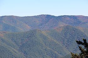
Shining Rock is a mountain in western North Carolina. The mountain is one of the Great Balsam Mountains which are a part of the Blue Ridge Mountains within the Appalachian Mountains. It is the 38th tallest mountain in the eastern United States.
Contents
- 3 day backpacking solo adventure shining rock wilderness north carolina
- Map of Shining Rock East Fork NC 28716 USA
- Shining rock hiking trip
- Cherokee lore
- References
Map of Shining Rock, East Fork, NC 28716, USA
Shining Rock is in the Shining Rock Wilderness near milepost 420 of the Blue Ridge Parkway. The Art Loeb Trail passes just below the summit.
Shining Rock is named for the large white quartzite rock outcropping near its summit.
Shining rock hiking trip
Cherokee lore
According to the Cherokee anthropologist James Mooney, the Cherokee name for Shining Rock, Datsu'nălâsgûñ'yĭ, translates to "where their tracks are this way" and refers to a rock that is said to have tracks of Tsul 'Kalu and his children.
This is distinct from Judaculla Rock which is discussed with Tsul 'Kalu, is south of the Blue Ridge Parkway and contains petroglyphs. Confusion arises because Judaculla (or Jutaculla) is a European corruption of the name Tsul 'Kalu; hence there appear to be two rocks of Cherokee lore named with variations of the name.