
Parent range Blue Ridge Mountains Mountain type granite Easiest route Hiking | Topo map USGS Range Blue Ridge Mountains Age of rock Precambrian | |
 | ||
Elevation Sharp Top 3,862 feet (1,177 m)
Flat Top 3,994 feet (1,217 m)
Harkening Hill 3,372 feet (1,028 m) Location Bedford / Botetourt counties, Virginia, U.S. Similar Blue Ridge Mountains, Humpback Rock, Mabry Mill, Linville Falls, Blue Ridge Music Center | ||
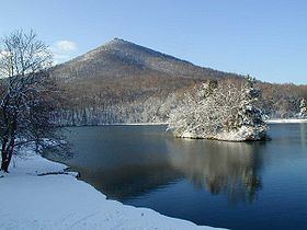
Peaks of otter hiking sharp top
The Peaks of Otter are three mountain peaks in the Blue Ridge Mountains, overlooking the town of Bedford, Virginia, nine miles (14 km) to the northeast along State Route 43. These peaks are
Contents
- Peaks of otter hiking sharp top
- Map of Peaks of Otter Peaks VA 24523 USA
- Otis series 1 hydraulic elevator peaks of otter lodge bedford va
- History
- Activities
- References
Map of Peaks of Otter, Peaks, VA 24523, USA
Manmade Abbott Lake lies in the valley between the three peaks, behind the Peaks of Otter Lodge and restaurant. The National Park Service preserves the peaks and lake as part of the Blue Ridge Parkway.
Thomas Jefferson once wrote that "the mountains of the Blue Ridge, and of these the Peaks of Otter, are thought to be of a greater height, measured from their base, than any others in our country, and perhaps in North America." Of course this later turned out not to be the case, but not before Virginia had sent stones from the peaks to be its part of the Washington Monument.
Otis series 1 hydraulic elevator peaks of otter lodge bedford va
History
At milepost marker 86 of the Blue Ridge Parkway stands the Peaks of Otter. It’s known that Native Americans used the peaks often for travel and rest and European settlers started establishing the area in the mid-1700s. In 1766 Thomas Wood and his family from Pennsylvania settled a homestead on the area; National Park Service documents indicate other early residents included brothers Charles and Robert Ewing, who are asserted by some to have named the Peaks after the Ewing surname as it is pronounced in Scottish Gaelic – Clann Eóghain na h-Oitrich, or "Clan Ewing of Otter." This view may be given credence by similarly Otter-themed place names in Scotland, and the resemblance of Flat Top to Beinn Dorain in the ancestral Ewing area of Argyll and Bute.
In 1834 the first local inn was created by the children of the Wood family and opened to travelers. In the late 1800s the Peaks of Otter was home to over 20 families, a school, a church, and a hotel. By the early 1900s the Peaks of Otter became a popular local tourist spot and became especially noticed by the National Park Service. Abbott Lake, the lake at the base of the peaks, was man made and created in 1964 along with the official Peaks of Otter Lodge, which still stands today.
Activities
There are three main peaks; Flat Top, Sharp Top, and Harkening Hill in order from highest peak altitude to lowest peak altitude. Aside from Sharp Top there is a separate cliff formation on the other side of the peak called Buzzard’s Roost, at about the same elevation as the rest of Sharp Top. Combined within the three peaks is a little over 12 miles of hiking and extra attractions along the way. On the outside of the valley, past the lodge, are the Peaks of Otter campgrounds, where there are trails, picnic tables, big open fields and outdoor grills. Johnson Farm is a historically restored site along one of the side trails towards Harkening Hill, it is an interactive, still functioning farm building from the early 1900s. From atop the peaks the very close town of Bedford can be seen within eyesight. On the summit of the far side of the main peak; Sharp Top, there is a famed crash site of a World War II B-25 bomber that crashed into the side of the mountain during a training exercise. The wreckage was never removed, as it is too heavy and the side of the mountain it crashed on is too steep to work on. There is a small memorial on a rock at the top of the site for the crew that died, it is a hike off trail, but the majority of the plane can still be found along the mountain with bigger parts further down as you go over an estimated area of 500x600 feet. There is also a bigger, more put-together World War II Memorial in nearby Bedford. This memorial is a D-Day memorial dedicated to all men who died in the Normandy landings, but especially to the ones from Bedford, who had the highest percentage of men killed in the initial landings, the most out any other single area in the whole country.