
Type Tiered Height 46 m | Total height 150 ft (46 m) Number of drops 4 | |
 | ||
Similar Blue Ridge Mountains, Crabtree Falls, Great Craggy Mountains, Moses H Cone Memorial, Waterrock Knob | ||
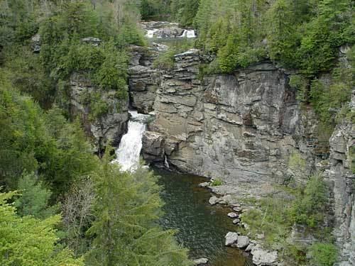
Linville falls jonas ridge nc
Linville Falls is a waterfall located in the Blue Ridge Mountains of North Carolina in the United States. The falls move in several distinct steps, beginning in a twin set of upper falls, moving down a small gorge, and culminating in a high-volume 45-foot (14 m) drop. It is named for the Linville River, which goes over the falls. Linville Falls has the highest volume of any waterfall on the Northern Edge of the Blue Ridge Mountains.
Contents
- Linville falls jonas ridge nc
- Map of Linville Falls Jonas Ridge NC USA
- Easiest fastest hike into the linville gorge linville falls introduction
- Natural history
- History
- Visiting the falls
- Nearby falls
- References
Map of Linville Falls, Jonas Ridge, NC, USA
Easiest fastest hike into the linville gorge linville falls introduction
Natural history
Linville Falls marks the beginning of the Linville Gorge, which is formed by the Linville River, which continues on after the falls before finally ending near Lake James.
History
According to personnel at Linville Falls, the falls were used by local Native Americans to execute prisoners. No one is known to have survived a fall over the final plunge, except for kayaker Pat Keller in 2010.
The falls were donated to the National Park Service in 1952 by John D. Rockefeller, Jr. He provided about $100,000 for purchase of the land, including a 1,100-acre (4.5 km2) area surrounding the falls and a part of Linville Gorge, from Giulia Luginbuhl of Des Moines, IA, whose father, F. W. Hossfeld of Morganton, NC, had purchased the property about 1900.
At one time, the upper section of the main plunge was the same height as the lower section, however, flooding caused the upper section to collapse on top of the lower falls, making the lower falls a considerably longer plunge.
Visiting the falls
The falls is owned by the National Park Service, which operates a visitor center and several miles of non-handicapped accessible trails with 4 overlooks for the falls. The 0.5-mile (0.80 km) Upper Falls trail leads to the top of the falls, where visitors can see the small twin upper falls and the water spiraling through a small canyon on its way to the main falls. The Erwin's View trail leads to 2 overlooks, the Chimney View overlook (0.7 miles) and the Erwin's View overlook (0.8 miles). The 0.5-mile (0.80 km) Plunge Basin Trail leads to the Plunge Basin Overlook, which provides a view of the falls from the other side of the river. Finally, the 0.7-mile (1.1 km) Gorge Trail, which branches off from the Plunge Basin trail, leads to an area near the foot of the falls. Swimming is prohibited at all areas of Linville Falls, as many deaths have occurred.