
Existed: 1926 – present Constructed 1926 | North end: CR 40 Length 29.97 km | |
 | ||
Counties Franklin County, Arkansas, Little River County, Arkansas, Logan County, Arkansas, Sevier County, Arkansas | ||
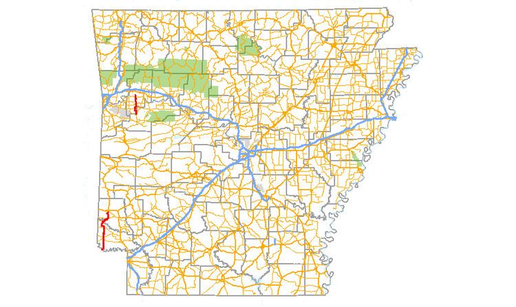
Arkansas Highway 41 (AR 41, Hwy. 41) is a designation for two state highways in Western Arkansas. One route of 18.02 miles (29.00 km) runs from Franklin County Route 40 (CR 40) south to Highway 23 near Chismville. A second routing begins at US Route 70B (US 70B) in De Queen and runs south to Texas State Highway 8 at the Texas state line. The northern segment of Highway 41 contains a 0.60 miles (0.97 km) officially designated exception over Highway 22 in Branch.
Contents
- Map of AR 41 Arkansas USA
- County Route 40 to Chismville
- De Queen to Texas
- De Queen business route
- References
Map of AR-41, Arkansas, USA
County Route 40 to Chismville
The route begins near the Arkansas River at a Corps of Engineers park called Citadel Bluff. Highway 41 runs south to a junction with Highway 96 in Cecil and continues to wind further south to Peter Pender, where the route has junctions with Highway 288 and Highway 60. South of these junctions Highway 41 serves as the western terminus for Highway 398 north of Branch. Upon entering Branch, Highway 41 forms an officially designated exception in which it shares the same strip of pavement with Highway 22 for 0.60 miles (0.97 km) westbound. The route turns left and runs south into Logan County, where the route terminates at Highway 23 near Chismville. Traffic counts from the Arkansas State Highway and Transportation Department (AHTD) reveal that no more than 800 vehicles per day (VPD) used Highway 41 along its routing from Citadel Bluff to Highway 23.
De Queen to Texas
AR 41 begins at US 70 Business and Highway 329 in De Queen and runs south to a junction with Highway 24 near Horatio. These two routes form a concurrency through Horatio which ends when Highway 24 at Williams Street with Highway 41 continuing southwest past the Pond Creek National Wildlife Refuge into Little River County. Upon crossing the Little River the highway has a junction with Highway 380 at Billingsly's Corner before winding south to cross Highway 234 at Cross Roads. The route becomes a section line road and continues along this line into Foreman where the route becomes Madden Street. Highway 41 intersects Highway 32 and Highway 108, and continues south in a brief overlap with Highway 32. This overlap concludes shortly south of town and Highway 41 continues along the section line due south to meet the Red River at the Texas state line, where it becomes State Highway 8.
De Queen business route
Arkansas Highway 41 Business (AR 41B, Hwy. 41B) was a business route of 0.9 miles (1.4 km) in De Queen. The highway ran from Highway 41 south of De Queen to US 70 Business.
The entire route is in De Queen, Sevier County.