
Founded 19 December 1837 Unemployment rate 5.5% (Apr 2015) | Area 1,606 km² Population 18,034 (2013) | |
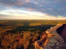 | ||
Points of interest Turner Bend Store, White Rock Mountain, Post Familie Vineyards, Aux Arc Park, Redding Recreation Area | ||
Franklin County is a county located in the U.S. state of Arkansas. As of the 2010 census, the population was 18,125. The county has two county seats, Charleston and Ozark. The county was formed on December 19, 1837, and named for Benjamin Franklin, American statesman. To the north of the Arkansas River, which bisects Franklin County, the county is wet and alcohol is sold in liquor stores, bars and local vineyards. To the south of the Arkansas River, the county is dry.
Contents
- Map of Franklin County AR USA
- History
- Geography
- Major highways
- Adjacent counties
- National protected area
- Demographics
- Cities
- Town
- Unincorporated communities
- Ghost town
- Townships
- References
Map of Franklin County, AR, USA
History
Franklin County was carved out of Crawford County in December 1837. At that time, Franklin was significantly larger than it is at present, encompassing part of present-day Logan County which was formed in 1871.
Initially, the county had a single courthouse at Ozark. Later, after complaints about how difficult it was to cross the river at times, a second courthouse was established at Charleston, sometime in the 1890s.
The reality television show, The Simple Life, starring Nicole Richie and Paris Hilton was filmed in Altus in 2003.
Geography
According to the U.S. Census Bureau, the county has a total area of 620 square miles (1,600 km2), of which 609 square miles (1,580 km2) is land and 11 square miles (28 km2) (1.7%) is water.
Major highways
Adjacent counties
National protected area
Demographics
As of the 2000 United States Census, there were 17,771 people, 6,882 households, and 4,961 families residing in the county. The population density was 29 people per square mile (11/km²). There were 7,673 housing units at an average density of 13 per square mile (5/km²). The racial makeup of the county was 96.17% White, 0.62% Black or African American, 0.80% Native American, 0.26% Asian, 0.06% Pacific Islander, 0.74% from other races, and 1.35% from two or more races. 1.74% of the population were Hispanic or Latino of any race.
There were 6,882 households out of which 32.40% had children under the age of 18 living with them, 59.20% were married couples living together, 8.80% had a female householder with no husband present, and 27.90% were non-families. 24.60% of all households were made up of individuals and 12.40% had someone living alone who was 65 years of age or older. The average household size was 2.51 and the average family size was 2.99.
In the county, the population was spread out with 25.80% under the age of 18, 8.50% from 18 to 24, 26.70% from 25 to 44, 23.20% from 45 to 64, and 15.80% who were 65 years of age or older. The median age was 38 years. For every 100 females there were 98.00 males. For every 100 females age 18 and over, there were 95.80 males.
The median income for a household in the county was $30,848, and the median income for a family was $36,189. Males had a median income of $27,907 versus $18,822 for females. The per capita income for the county was $14,616. About 10.60% of families and 15.20% of the population were below the poverty line, including 16.20% of those under age 18 and 15.70% of those age 65 or over.
Cities
Town
Unincorporated communities
Ghost town
Townships
Townships in Arkansas are the divisions of a county. Each township includes unincorporated areas; some may have incorporated cities or towns within part of their boundaries. Arkansas townships have limited purposes in modern times. However, the United States Census does list Arkansas population based on townships (sometimes referred to as "county subdivisions" or "minor civil divisions"). Townships are also of value for historical purposes in terms of genealogical research. Each town or city is within one or more townships in an Arkansas county based on census maps and publications. The townships of Franklin County are listed below; listed in parentheses are the cities, towns, and/or census-designated places that are fully or partially inside the township.