
East end: AR 41 at Peter Pender | Length 13.7 km | |
 | ||
West end: Old AR 10 at the Sebastian County line | ||
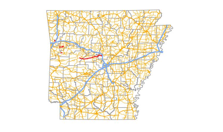
Arkansas Highway 60 (AR 60, Ark. 60, Hwy. 60) is a state highway that exists in five separate sections in Arkansas. The longest and most well-known segment of 54.19 miles (87.21 km) runs from Highway 28 in Plainview east to U.S. Route 65B (US 65B) in Conway. A segment in western Logan County of 2.64 miles (4.25 km) begins at the Old Highway 10 at the Sebastian County line and runs east to Highway 10. A third segment of 10.80 miles (17.38 km) begins at Highway 252 near Lavaca and runs east to Highway 41 at Peter Pender. A fourth segment runs 1.34 miles (2.16 km) from US 64 and runs across Interstate 40/Interstate 540 (I-40/I-540) to Highway 282. A fifth route of 2.34 miles (3.77 km) begins at Highway 282 near Rudy and runs north to County Road 23 (CR 23).
Contents
- Map of AR 60 Arkansas USA
- Rudy to CR23
- US64 to Highway 282
- Sebastian Franklin counties
- Logan County
- Main segment
- Major intersections
- References
Map of AR-60, Arkansas, USA
Rudy to CR 23
The longer section of Highway 60 in Crawford County is 2.34 miles (3.77 km) long. The route runs north from Highway 282 at Rudy to terminate at Crawford County Road 23.
US 64 to Highway 282
The shorter section of Highway 60 in Crawford County is 1.90 miles (3.06 km) long. The route runs north from US 64 over Interstate 40 to terminate at Highway 282.
This segment is the only section of Highway 60 that is signed north-south, as opposed to the rest of the highway, which is signed east-west.
Sebastian / Franklin counties
The section of Highway 60 in Franklin and Sebastian counties is 8.5 miles (13.7 km) long. The westernmost 1.1 miles (1.8 km) is located in Franklin County, with the remaining 7.4 miles (11.9 km) in Franklin County. The route runs east from Highway 217 to terminate at Highway 41 at Peter Pender.
Logan County
The section of Highway 60 in Logan County runs for 2.64 miles (4.25 km). The route runs east from the Sebastian County line to Highway 10 west of Booneville
Main segment
Highway 60 begins at U.S. Route 65 Business in Conway. It runs west for 1.5 miles (2.4 km) and intersects with spur route 60. It continues west for 5.5 miles (8.9 km) until it reaches the County Line at the overpass of Toad Suck Ferry Lock and Dam. Highway 60 then continues to run west for 7.7 miles (12.4 km) and meets with Highway 113. It continues west for 3.8 miles (6.1 km) with Highway 113 and meets the northern terminus of Highway 216 in Houston.
0.1 miles (0.16 km) west of Highway 216, Highway 113 splits off from Highway 60. Highway 60 then runs west for 6.5 miles (10.5 km) to Perryville where it intersects with Highway 9. Both highways follow the same path south in Perryville for 0.3 miles (0.48 km) where they diverge. Highway 60 then runs west for 10.8 Miles to where it intersects with the northern terminus of Highway 177. It then runs west for another 10.1 miles (16.3 km) until it intersects with Arkansas Highway 7. It then crosses Highway 7 and runs west 1.6 miles (2.6 km) to the county line.
From the county line, Highway 60 runs west 7.0 miles (11.3 km) to terminate at Highway 28. Along this route it passes by Nimrod Lake.
Major intersections
The entire route is in Crawford County.
The entire route is in Logan County.