
Country China Postal code 830000 License plate prefixes 新A Local time Sunday 1:35 PM | County-level divisions 8 Area code(s) 991 Area 10,989 km² | |
 | ||
Time zone Weather 13°C, Wind NW at 6 km/h, 49% Humidity Points of interest | ||
Ürümqi (Chinese: 乌鲁木齐; pinyin: Wūlǔmùqí, Uyghur: ئۈرۈمچى; from Oirat "beautiful pasture") is the capital of the Xinjiang Uyghur Autonomous Region of the People's Republic of China in Northwest China. Ürümqi was a major hub on the Silk Road during China's Tang dynasty, and developed its reputation as a leading cultural and commercial center during Qing dynasty in 19th Century.
Contents
- Map of C39CrC3BCmqi Xinjiang China
- Early period
- Dzungar period
- Qing rule
- Republican era
- Peoples Republic era
- July 2009 riots and subsequent unrest
- Geography
- Water supply
- Climate
- Air quality and pollution
- Timing of sunrise
- Administrative divisions
- Demographics
- Economy
- Tourism
- Education and science
- Universities
- High schools
- Research institutes
- Air
- Rail
- Road
- Metro
- Bus rapid transit
- Media
- Sport
- Twin towns and sister cities
- References
Map of %C3%9Cr%C3%BCmqi, Xinjiang, China
With an estimated population of 3.5 million in 2015, Ürümqi is the largest city in China's western interior as well as in Central Asia in terms of the population. Ürümqi has seen a huge economical development since the 1990s and currently serves as a regional transport node, a cultural, political and commercial center.
Early period
Although Ürümqi is situated near the northern route of the Silk Road, the present city is a relatively young city. It was not called Urumqi until the time of the Dzungar Khanate. An older settlement named Luntai was located nearby, around 10 kilometres (6 miles) from the southern suburb of present-day Ürümqi. Luntai was set up by the Tang government during the 22nd year of Emperor Taizong's reign (648 AD) in the ancient town seat of Urabo as part of the Protectorate General to Pacify the West that controlled Xinjiang. It was a seat of local government, and collected taxes from the caravans along the northern route of the Silk Road. After the Tang retreated from the Western Regions, the region came under the control of the Uyghurs of the Khaganate and Gaochang/Qocho. From Tang to Qing Dynasty, there was little information about the Ürümqi area, and there appeared to be no permanent settlement here for most of this period. The Mongols referred to the wider area as Bishbalik meaning five cities, referring to the five towns that surrounded the present-day Ürümqi area.
Dzungar period
The Oirats Dzungar tribes that formed the Dzungar Khanate were the last major power to control Ürümqi before the Manchus gained control of Xinjiang, and their language gave Ürümqi its modern-day name. In the Ming dynasty, there was a record of a place at Jiujiawan 5 kilometres (3 miles) to the west of present Ürümqi, which may have been the Dzunghar town that was later destroyed during the Qing conquest. The Mongolians also used the area as herding ground in this period. Steppe peoples had used the location, the pass between the Bogda Shan to the east and the Tian Shan to the west, connecting the Dzungar Basin to the north and the Turpan Depression to the south.
Ürümqi remained a small town, and less important than the oasis and Silk Road trade center Turpan 200 km (120 mi) to the southeast. Fighting for the control of Dzungaria led to the Khoshuuts (now classified as Mongols) leaving Ürümqi for Qinghai and Tibet in the 1620s and 1630s. The Uyghurs were introduced into the Ürümqi area in the 18th century by the Dzunghars who moved them from the west Tarim region to be taranchis or farmers in Ürümqi.
Qing rule
In the 18th century, the Qing went to war against the Dzungar Khanate. Ürümqi was taken by the Qing in 1755, and the Dzungars of the region were eliminated in the Dzungar genocide. One writer, Wei Yuan, described the resulting desolation in what became northern Xinjiang as "an empty plain for a thousand li, with no trace of man". A fort was built (either in 1755 or 1758 depending on sources), and the Qing then established garrisons of Manchu and Mongol bannermen and Han Chinese troops at Ürümqi. After 1759, the Qing government established state farms in the under-populated areas around Urumqi, where there were fertile, well-watered land. The Manchu soldiers also constructed a temple with red wall dedicated to Guandi on Pingding mountain overlooking Urumqi, which gave Urumqi its nickname, Red Temple.
The Manchus began to construct a walled city in 1763 to the south of the first fort, and it was completed in 1767. The Qianlong Emperor had named the new settlement "Dihua" (Chinese: 迪化; pinyin: Díhuà; Manchu: Wen de dahabure fu), meaning "to enlighten". In 1771, another city named Gongning Cheng (鞏寧城) was built nearby to the northwest to house Manchu bannermen, and this would become the seat of government. The bannermen settlement to the west was commonly referred to as Mancheng (滿城, Manchu City), while Dihua to the east became a Han Chinese town commonly called Hancheng (Han City). The Ürümqi of the early period was therefore a twin-city, with Gongning Cheng the administrative center while Dihua grew into Xinjiang's commercial and financial center.
Chinese Hui Muslims from Gansu and Shaanxi, Han Chinese from all over China began to move into Dihua. By 1762, more than 500 shops had already been opened by Chinese migrants to the area of modern-day Ürümqi. Those Qing literati who visited Dihua were impressed by its cultural sophistication and similarity to eastern China. The writer Ji Xiaolan compared Dihua to Beijing, in that both had numerous wine shops which offered daily performances of Chinese music and dance. The origin of Hui in Urumqi is often indicated by the names of their Mosques.
The Battle of Ürümqi took place in 1870 between the Turkic Muslim forces of Yaqub Beg against the Dungan Muslim forces of Tuo Ming (Daud Khalifa). With the help of Xu Xuegong's Han Chinese militia, Yaqub Beg's forces defeated the Dungans. Gongning Cheng was captured, its Qing administrator killed, and the city burnt to the ground and abandoned. The Qing later regained control of Ürümqi. In 1884, the Guangxu Emperor established Xinjiang as a Province, with Dihua as its capital.
Republican era
After the collapse of the Qing dynasty, Xinjiang was ruled from Ürümqi by a succession of warlords: Yang Zengxin (1911–1928), Jin Shuren (1928–1933), and Sheng Shicai (1933–1942), finally Zhang Zhizhong as governor of Xinjiang in 1942–1949. Of these, Yang and Sheng were considered capable rulers.
During the Kumul Rebellion the Battle of Ürümqi (1933) and the Battle of Ürümqi (1933–34) took place between the forces of Ma Zhongying's 36th Division (National Revolutionary Army) and Jin Shuren and Sheng Shicai's provincial forces. At the second battle Ma was assisted by the Han Chinese General Zhang Peiyuan.
People's Republic era
Following the founding of the People's Republic of China, on 1 February 1954, the city's name was officially changed back to its Dzungar Oirat name Ürümqi, meaning "beautiful pasture" in the Oirat language of the Dzungar people.
In the late 1970s, Deng Xiaoping relaxed China's tight control over Xinjiang, which led to a boom of Ürümqi from the development of oil and gas industry in Xinjiang.
New mosques were built in Ürümqi with financial assistance from the Chinese government. While the Chinese government implemented strict rules on religion in southern Xinjiang, the treatment of the Uyghurs and their religion in Ürümqi were more lax and permissive.
The city however suffered from a series of unrest, In May 1989, unrest in Ürümqi resulted in 150 injuries. In February 1997, bombings in Ürümqi following the Ghulja incident resulted in 20 deaths and scores of injuries.
July 2009 riots and subsequent unrest
In the largest eruption of ethnic violence in China in decades, major rioting broke out in July 2009 between ethnic Han Chinese and Uyghurs. The New York Times reporter covering the riot described the violence as "clashes with riot police and Uighurs rampaging through the city and killing Han civilians. Then, for at least three days, bands of Han vigilantes roamed Urumqi, attacking and killing Uighurs." Before the riot broke out, young Uighurs had marched through the city "to protest a case of judicial discrimination". According to official figures, most of the 197 killed in the riot were Han, a statement disputed by Uighurs.
Geography
The largest city in western China, Ürümqi has earned a place in the Guinness Book of Records as the most remote city from any sea in the world. It is about 2,500 kilometres (1,600 mi) from the nearest coastline as Ürümqi is the closest major city to the Eurasian pole of inaccessibility, although Karamay and Altay, both in Xinjiang, are closer. The city has an administrative area of 10,989 square kilometres (4,243 sq mi) and has an average elevation of 800 metres (2,600 ft).
The location 43°40′52″N 87°19′52″E in the southwestern suburbs of Ürümqi (Ürümqi County) was designated by local geography experts as the "center point of Asia" in 1992, and a monument to this effect was erected there in the 1990s. The site is a local tourist attraction.
Water supply
Although surrounded by deserts (the Gurbantünggüt in the north and the Taklamakan in the south), the Ürümqi area is naturally watered by a number of small rivers flowing from the snow-capped Tian Shan mountains: the main range of the Tian Shan in south of the city (Ürümqi County), and the Bogda Shan east of the city (Dabancheng District). A network of small reservoirs and canals redistribute the water throughout the extensively irrigated area along the foothills of the mountain ranges.
As the Ürümqi region's population and economy is growing, the water demand exceeds the natural supply. To alleviate water shortages, the Irtysh–Ürümqi Canal was constructed in the first decade of the 21st century. The canal's main trunk terminates in the so-called "Reservoir 500" ("500"水库; 44°12′00″N 87°49′00″E) in the far north-eastern suburbs of the city (on the border of Ürümqi's suburban Midong District and Fukang City). A new industrial area, called Ganquanbao Industrial Park (甘泉堡工业园), or Industrial New City 500 (500工业新城) was being developed in 2009, west of the reservoir, relying on it for water supply. From the reservoir area water is further distributed over a network of canals throughout the lower Midong District.
Climate
In Ürümqi a continental semi-arid climate (Köppen climate classification BSk) prevails, with very large differences between summer and winter, warm summers, with a July daily average of 23.7 °C (74.7 °F), and very cold winters, with a January daily average of −12.6 °C (9.3 °F). The annual average temperature is 6.90 °C (44.4 °F). The city is semi-arid, with its summers slightly wetter than its winters, yet sunny weather is much more likely in the warmer months, and relative humidity is the lowest during summer. With monthly percent possible sunshine ranging from 30 percent in December to 70 percent in August and September, the city receives 2,523 hours of bright sunshine annually. Its annual precipitation is about 290 millimetres (11.4 in). Extremes since 1951 have ranged from −41.5 °C (−43 °F) on 27 February 1951 to 42.1 °C (108 °F) on 1 August 1973.
Air quality and pollution
According to the National Environmental Analysis released by Tsinghua University and the Asian Development Bank in January 2013, Urumqi is among the top ten cities in the world with the most air pollution. According to this report, seven of these cities are in China, including Taiyuan, Beijing, Lanzhou, Chongqing, Jinan, and Shijiazhuang (besides Ürümqi).
Blacksmith Institute mentioned Urumqi in 2007 World’s Worst Polluted Places caused by air pollution along with Linfen and Lanzhou, all in China. In 2008, Toronto Star listed Ürümqi as one of the Top Ten worst places to live in the world due to sulphurous pollution. Heavy haze is extremely common in winter, which frequently affects air traffic. Officials believed that severe winter air pollution in Ürümqi is mainly caused by energy-heavy industries and the outdated coal-firing winter heating system. According to a report by Department of Environmental Science and Engineering of Fudan University, the average PM2.5 and TSP concentrations in the winter of 2007 were 12 times higher than USA standard for PM2.5 and 3 times the National Ambient Air Quality Standard of China for TSP. The sulfur dioxide from industrial emissions mixed with the local anthropogenic aerosol with the transported soil dust from outside the city was the main sources of the high concentration of sulfate, one of the main factors causing the heavy air pollution over Urumqi.
Timing of sunrise
Because of the use of a single time zone for all of China, in Ürümqi which is at a far western location in China, the sun is 2 hours and 10 minutes behind China Standard Time (CST = UTC+8). During early January the sun does not rise until 09:45 and it sets between 18:45 and 19:10 local time. In September and March the sun rises around 08:00, and sets around 19:45. However, in June the sun rises at about 06:25 and does not set until 21:45.
Administrative divisions
Ürümqi currently comprises 8 county-level subdivisions: 7 districts and 1 county.
Demographics
Ürümqi has been a multi-ethnic city from the time of the Qing conquest; in the early years, the Manchus lived in Gongning Cheng, Han Chinese in Dihua, and various other ethnic groups such as the Hui, Uyghurs and others in the suburban districts. The Muslims settled to the south of the walled-city of Dihua, and although the walls have since been demolished, the Muslims are still concentrated there. A census of in 1787 showed that there were 114,348 Hui and Han in the prefectures of Zhenxi (which included Barköl and Hami) and Ürümqi. In Ürümqi city itself, there were 39,000 people in the 1880s, and by the early 20th century, 50,000 people. Ürümqi in 1908 was said to have been inhabited by Uyghurs (then called Turkis), Chinese, Manchus and a few Mongols, with the Uyghurs estimated to comprise a quarter of the population.
In the People's Republic era, an active program to resettle Han population in Xinjiang was initiated. In 1960, there were 76,496 Uyghurs and 477,321 Han Chinese in Urumqi.
According to the 2000 census, Ürümqi had 2,081,834 inhabitants, with a population density of 174.53 inhabitants/km2 (452.3 inhabitants/sq. mi.).
In the 2010 census, the population was recorded as 3,112,559. Part of the increase is due to boundary changes, for example, Miquan was merged into Midong District and became part of Ürümqi in 2007.
Economy
Ürümqi is a major industrial center within Xinjiang. Ürümqi, together with Karamay and Korla, account for 64.5 percent of the total industrial output of Xinjiang. Ürümqi is also the largest consumer center in the region, recording ¥41.9 billion retail sales of consumer goods in 2008, an increase of 26 percent from 2007. The GDP per capita reached US$6,222 in 2008. According to statistics, Urumqi ranked 7th in 2008 by the disposable income for urban residents among cities in Western China. Ürümqi has been a central developmental target for the China Western Development project that the Central Government is pursuing.
The Urumqi Foreign Economic Relations and Trade Fair (Chinese: 乌洽会) has been held annually since 1991 and has been upgraded into the first China-Eurasia Expo in 2011. Its purpose is to promote domestic and foreign markets. The 17th Fair has attracted participants from the Ministry of Commerce and the China Council for Promotion of International Trade.
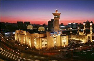
Xinjiang Guanghui Group (新疆广汇集团) is the largest real estate enterprise and most powerful privately owned company in Xinjiang and is currently engaged in energy and automobile. China CITIC Bank Mansion (中信银行大厦), headquarters of Guanghui, located in one of the CBDs in North Xinhua Road, is the tallest building in Urumqi and Xinjiang; with a height of 229 metres (751 feet), it is also the tallest in Northwestern China and Central Asia. Zhongshan Road (Sun Yat-sen Road, Chinese: 中山路) has been one of the ten most famous commercial streets in China since 2005. Zhongshan Road has always been the hub of consumer electronics in the city, with the largest computer, mobile phone and consumer electronics market in Xinjiang, including Baihuacun, Cyber Digital Plaza and Fountain Plaza.
As the economic center in Xinjiang, Urumqi has expanded its urban area since the 1990s. The CBDs in the city increased rapidly all around the major districts. Despite the old city areas being primarily in the south, the development in the north part began since the late 1980s. The completion of the new office tower for Urumqi Municipal Government in 2003 at Nanhu Square (南湖广场) in Nanhu Road marked a shift of the city center to the north. Lacking a subway, the city commenced the construction of viaducts for Outer Ring Road (外环路) since 2003, which considerably facilitates transport. Youhao Road (友好路) and surrounding neighborhood, is the commercial center for business, shopping and amusement. Youhao Group (友好集团), the namesake local enterprise, owns a major market share of retails. Maison Mode Urumqi (乌鲁木齐美美百货), open since 2008, became one of the few notable department stores for luxury merchandise in the city. The Urumqi Economic and Technological Development Zone (UETD) located in the northern Toutunhe District, has been a leading base for steel, machinery manufacturing, biochemistry and other industrial innovations.
Tourism
Education and science
Urumqi has many educational campuses including Xinjiang University, Xinjiang Normal University, Xinjiang Agricultural University, Xinjiang Medical University and many others.
Universities
High schools
Research institutes
Air
Ürümqi is served by the Ürümqi Diwopu International Airport. It is a hub for China Southern Airlines. Ürümqi Diwopu International Airport is the largest airport in Xinjiang.
Rail
Ürümqi is Xinjiang's main rail hub with two primary railway stations, the long-standing Ürümqi South Railway Station (formerly the Urumqi Railway Station) and Ürümqi Railway Station opened in July 2016. The a high-speed rail line connects both stations, running from Ürümqi to Lanzhou which has been in operation since the end of 2014.
The city is served by several conventional rail lines. Ürümqi is the western terminus of the Lanzhou–Xinjiang (Lanxin) and Ürümqi–Dzungaria (Wuzhun) Railway, and the eastern terminus of the Northern Xinjiang (Beijiang) and the Second Ürümqi–Jinghe Railway. The Beijiang and the Lanxin Lines form part of the Trans-Eurasian Continental Railway, which runs from Rotterdam through the Alataw Pass on the Kazakhstan border to Ürümqi and on to Lanzhou and Lianyungang.
Road
Many roads to the north and west typically shut down by early October, remaining closed until the end of winter.
Metro
The Ürümqi Metro is under construction with plans submitted for 7 lines totalling 211.9 kilometres (131.7 miles) in length with an estimated cost of 31.24 billion yuan.
Since 20 March 2014 Line 1 has been under construction and is expected to open in 2019. The line will connect Ürümqi Diwopu Airport through downtown Ürümqi and end at the Southern Long Distance Bus Station (南郊客运站) with a total length of 26.5 kilometres (16.5 miles) and 21 stations (16 underground, 5 elevated).
Bus rapid transit
The Ürümqi BRT bus service was launched in August 2011 after an investment of 930 million yuan in an effort to improve urban traffic. There are currently four routes operated, BRT1, BRT2, BRT3, and BRT5 mainly along the north-to-south downtown major roads.
Media
The Xinjiang Networking Transmission Limited operates the Urumqi People's Broadcasting Station and the Xinjiang People Broadcasting Station, broadcasting in the Mandarin, Uyghur, Kazakh, Mongolian, Russian and the Kyrgyz languages.
The Xinjiang Television Station (XJTV), located in Urumqi, is the major TV broadcasting station in the Xinjiang Uyghur Autonomous Region. The local television station for Urumqi city is Urumqi Television Station (UTV)(乌鲁木齐电视台).
Sport
China started a bandy development programme by organising educational days in Ürümqi in June 2009.
In 2015 an indoor speed skating arena was opened.
Twin towns and sister cities
Ürümqi is twinned with:
^1 Almaty is a state-level city of Kazakhstan