
Chinese 塔里木盆地 Wade–Giles T'a-li-mu P'en-ti Chinese 南疆 | Hanyu Pinyin IPA [tʰàkʰùmû pʰə̌ntî] Literal meaning Southern Xinjiang | |
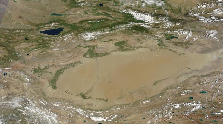
The Tarim Basin is an endorheic basin in northwest China occupying an area of about 1,020,000 km2 (390,000 sq mi). Located in China's Xinjiang region, it is sometimes used synonymously to refer the southern half of the province, or Nanjiang (Chinese: 南疆; pinyin: Nánjiāng; literally: "Southern Xinjiang"), as opposed to the northern half of the province known as Dzungaria or Beijiang. Its northern boundary is the Tian Shan mountain range and its southern boundary is the Kunlun Mountains on the edge of the Qinghai-Tibet Plateau. The Taklamakan Desert dominates much of the basin. The historical Uyghur name for the Tarim Basin is Altishahr (六域), which means "six cities" in Uyghur.
Contents
- The tarim basin mummies by victor mair
- Geography and relation to Xinjiang
- Tarim Basin locations
- Geology
- History
- Early periods
- Han dynasty
- SuiTang dynasties
- Kingdom of Khotan
- Turkic influx
- Islamisation of the Tarim Basin
- Turkic Islamic Kara Khanid conquest of Iranic Saka Buddhist Khotan
- Conversion of the Buddhist Uyghurs
- Qing dynasty
- People of Tarim Basin
- Archaeology
- References
The tarim basin mummies by victor mair
Geography and relation to Xinjiang
Xinjiang consists of two main geographically, historically, and ethnically distinct regions with different historical names, Dzungaria and the Tarim Basin (Altishahr), before Qing China unified them into one political entity called Xinjiang province in 1884. At the time of the Qing conquest in 1759, Dzungaria was inhabited by steppe dwelling, nomadic Tibetan Buddhist Dzungar people, while the Tarim Basin (Altishahr) was inhabited by sedentary, oasis dwelling, Turkic speaking Muslim farmers, now known as the Uyghur people. They were governed separately until 1884.
Tarim Basin locations
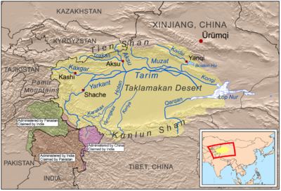
North side: The Chinese called this the Tien Shan Nan Lu or Tien Shan South Road, as opposed to the Bei Lu north of the mountains. Along it runs the modern highway and railroad while the middle Tarim River is about 100 km south. Kashgar was where the caravans met before crossing the mountains. Bachu or Miralbachi; Uchturpan north of the main road; Aksu on the large Aksu River; Kucha was once an important kingdom; Luntai; Korla, now a large town; Karashar near Bosten Lake; Turpan north of the Turpan Depression and south of the Bogda Shan; Hami; then southeast to Anxi and the Gansu Corridor.
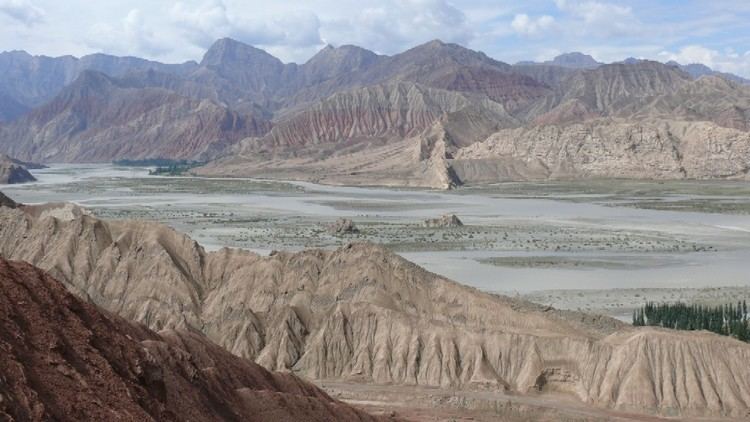
Center: Most of the basin is occupied by the Taklamakan Desert which is too dry for permanent habitation. The Yarkand, Kashgar and Aksu Rivers join to form the Tarim River which runs along the north side of the basin. Formerly it continued to Loulan, but some time after 330AD it turned southeast near Korla toward Charkilik and Loulan was abandoned. The Tarim ended at the now-dry Lop Nur which occupied a changing position east of Loulan. Eastward is the fabled Jade Gate which the Chinese considered the gateway to the Western Regions. Beyond that is Dunhuang with its ancient manuscripts and then Anxi at the west end of the Gansu Corridor.
South side: Kashgar; Yangi Hissar, famous for its knives; Yarkand, once larger than Kashgar; Karghalik (Yecheng), with a route to India; Karakash; Khotan, the main source of Chinese jade; eastward the land becomes more desolate; Keriya (Yutian); Niya (Minfeng); Qiemo (Cherchen); Charkilik (Ruoqiang). The modern road continues east to Tibet. There is no current road east across the Kumtag Desert to Dunhuang, but caravans somehow made the crossing thru the Yangguan pass south of the Jade Gate.
Roads and passes, rivers and caravan routes: The Southern Xinjiang Railway branches from the Lanxin Railway near Turpan, follows the north side of the basin to Kashgar and curves southeast to Khotan.
Roads:The main road from eastern China reaches Urumchi and continues as highway 314 along the north side to Kashgar. Highway 315 follows the south side from Kashgar to Charkilik and continues east to Tibet. There are currently four north-south roads across the desert. 218 runs from Charkilik to Korla along the former course of the Tarim forming an oval whose other end is Kashgar. The Tarim Desert Highway, a major engineering achievement, crosses the center from Niya to Luntai. The new Highway 217 follows the Khotan River from Khotan to near Aksu. A road follows the Yarkand River from Yarkand to Baqu. East of the Korla-Charkilik road travel continues to be very difficult.
Rivers coming south from the Tien Shan join the Tarim, the largest being the Aksu. Rivers flowing north from the Kunlun are usually named for the town or oasis they pass through. Most dry up in the desert, only the Hotan River reaching the Tarim in good years. An exception is the Qiemo River which flowed northeast into Lop Nor. Ruins in the desert imply that these rivers were once larger.
Caravans and passes: The original caravan route seems to have followed the south side. At the time of the Han Dynasty conquest it shifted to the center (Jade Gate-Loulan-Korla). When the Tarim changed course about 330AD it shifted north to Hami. A minor route went north of the Tian Shan. When there was war on the Gansu Corridor trade entered the basin near Charkilik from the Qaidam Basin. The original route to India seems to have started near Yarkand and Kargilik, but it is now replaced by the Karakoram Highway south from Kashgar. To the west of Kashgar via the Irkeshtam border crossing is the Alay Valley which was once the route to Persia. Northeast of Kashgar the Torugart pass leads to the Ferghana Valley. Somewhere near Aksu the difficult Muzart Pass led north to the Ili River basin (Kulja). Near Korla was the Iron Gate Pass and now the highway and railway north to Urumchi. From Turfan the easy Dabancheng pass leads to Urumchi. The route from Charkilik to the Qaidam Plateau was of some importance when Tibet was an empire.
North of the Mountains is Dzungaria with its central Gurbantünggüt Desert, Urumchi the capital and the Karamay oil fields. The Kulja territory is the upper basin of the Ili River and opens out onto the Kazakh steppe with several roads eastward. The Dzungarian Gate was once a migration route and is now a road and rail crossing. Tacheng or Tarbaghatay is a road crossing and former trading post.
Geology
The Tarim Basin is the result of an amalgamation between an ancient microcontinent and the growing Eurasian continent during the Carboniferous to Permian periods. At present, deformation around the margins of the basin is resulting in the microcontinental crust being pushed under Tian Shan to the north, and Kunlun Shan to the south.
A thick succession of Paleozoic, Mesozoic and Cenozoic sedimentary rocks occupy the central parts of the basin, locally exceeding thicknesses of 15 km (9 mi). The source rocks of oil and gas tend to be Permian mudstones. Below this level is a complex Precambrian basement believed to be made up of the remnants of the original Tarim microplate, which accrued to the growing Eurasian continent in Carboniferous time. The snow on K2, the second highest mountain in the world, flows into glaciers which move down the valleys to melt. The melted water forms rivers which flow down the mountains and into the Tarim Basin, never reaching the sea. Surrounded by desert, some rivers feed the oases where the water is used for irrigation while others flow to salt lakes and marshes.
Lop Nur is a marshy, saline depression at the east end of the Tarim Basin. The Tarim River ends in Lop Nur.
The Tarim Basin is believed to contain large potential reserves of petroleum and natural gas. Methane comprises over 70 percent of the natural gas reserve, with variable contents of ethane (<1% ~18%) and propane (<0.5% ~9%). China National Petroleum Corporation's comprehensive exploration of the Tarim basin between 1989 and 1995 led to the identification of 26 oil- and gas-bearing structures. These occur at deeper depths and in scattered deposits. Beijing aims to develop Xinjiang into China's new energy base for the long run, supplying one-fifth of the country's total oil supply by 2010, with an annual output of 35 million tonnes. On June 10, 2010 Baker Hughes announced an agreement to work with PetroChina Tarim Oilfield Co. to supply oilfield services, including both directional and vertical drilling systems, formation evaluation services, completion systems and artificial lift technology for wells drilled into foothills formations greater than 7,500 meters (24,600 feet) deep with pressures greater than 20,000 psi (1379 bar) and bottomhole temperatures of approximately 160 °C (320 °F). Electrical submersible pumping (ESP) systems will be employed to dewater gas and condensate wells. PetroChina will fund any joint development.
In 2015, Chinese researchers published the finding of a vast, carbon-rich underground sea beneath the basin.
History
It is speculated that the Tarim Basin may be one of the last places in Asia to have become inhabited: It is surrounded by mountains and irrigation technologies might have been necessary.
The Northern Silk Road on one route bypassed the Tarim Basin north of the Tian Shan mountains and traversed it on three oases-dependent routes: one north of the Taklamakan Desert, one south, and a middle one connecting both through the Lop Nor region.
Early periods
The earliest inhabitants of the Tarim Barin may be the Tocharians whose languages are the easternmost group of Indo-European languages. Europoid mummies have been found in various locations in the Tarim Basin such as Loulan, the Xiaohe Tomb complex, and Qäwrighul. These mummies have been suggested to be of Tocharian origin, and these people may have inhibited the region since at least 1800 BCE. They may be related to the "Yuezhi" (Chinese 月氏; Wade–Giles: Yüeh-Chih) mentioned in Chinese texts. Protected by the Taklamakan Desert from steppe nomads, elements of Tocharian culture survived until the 7th century, when the arrival of Turkic immigrants from the collapsing Uyghur Khaganate of modern-day Mongolia began to absorb the Tocharians to form the modern-day Uyghur ethnic group.
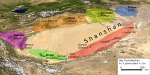
Another people in the region besides Tocharian are the Indo-Iranian Saka people who spoke various Eastern Iranian Khotanese Scythian or Saka dialects. In the Achaemenid-era Old Persian inscriptions found at Persepolis, dated to the reign of Darius I (r. 522-486 BC), the Saka are said to have lived just beyond the borders of Sogdiana. Likewise an inscription dated to the reign of Xerxes I (r. 486-465 BC) has them coupled with the Dahae people of Central Asia. The contemporary Greek historian Herodotus noted that the Achaemenid Persians called all of the Indo-Iranian Scythian peoples as the Saka. They were known as the Sai (塞, sāi, sək in archaic Chinese) in ancient Chinese records. These records indicate that they originally inhabited Ili and Chu River valleys of modern Kazakhstan. In the Chinese Book of Han, the area was called the "land of the Sai", i.e. the Saka. Presence of a people believed to be Saka has also been found in various location in the Tarim Basin, for example in the Keriya region at Yumulak Kum (Djoumboulak Koum, Yuansha) around 200 km east of Khotan, with a tomb dated to as early as the 7th century BC.
According to the Sima Qian's Shiji, the nomadic Indo-European Yuezhi originally lived between Tengri Tagh (Tian Shan) and Dunhuang of Gansu, China.> However, the Yuezhi were assaulted and forced to flee from the Hexi Corridor of Gansu by the Mongolic forces of the Xiongnu ruler Modu Chanyu, who conquered the area in 177-176 BC (decades before the Han Chinese conquest and colonization of Gansu or the establishment of the Protectorate of the Western Regions). In turn the Yuezhi were responsible for attacking and pushing the Sai (i.e. Saka) west into Sogdiana, where in the mid 2nd century BC the latter crossed the Syr Darya into Bactria, but also into the Fergana Valley where they settled in Dayuan, southwards towards northern India, and eastward as well where they settled in some of the oasis city-states of the Tarim Basin. Whereas the Yuezhi continued westward and conquered Daxia around 177-176 BC, the Sai (i.e. Saka), including some allied Tocharian peoples, fled south to the Pamirs before heading back east to settle in Tarim Basin sites like Yanqi (焉耆, Karasahr) and Qiuci (龜茲, Kucha). The Saka are recorded as inhabiting Khotan by at least the 3rd century and also settled in nearby Shache (莎車), a town named after the Saka inhabitants (i.e. saγlâ). Although the ancient Chinese had called Khotan Yutian (于闐), it's more native Iranian names during the Han period were Jusadanna (瞿薩旦那), derived from Indo-Iranian Gostan and Gostana, the names of the town and region around it, respectively.
Han dynasty
Around 200 BCE, the Yuezhi were overrun by the Xiongnu. The Xiongnu tried to invade the western region of China, but ultimately failed and lost control of the region to the Chinese. The Han Chinese wrested control of the Tarim Basin from the Xiongnu at the end of the 1st century under the leadership of General Ban Chao (32–102 CE), during the Han-Xiongnu War. The Chinese administered the Tarim Basin as the Protectorate of the Western Regions. The Tarim Basin was later under many foreign rulers, but ruled primary by Turkic, Han, Tibetan, and Mongolic peoples.
The powerful Kushans expanded back into the Tarim Basin in the 1st–2nd centuries CE, where they established a kingdom in Kashgar and competed for control of the area with nomads and Chinese forces. They introduced the Brahmi script, the Indian Prakrit language for administration, and Buddhism, playing a central role in the Silk Road transmission of Buddhism to Eastern Asia.
Sui–Tang dynasties
After the Han dynasty, the Kingdoms of the Tarim Basin began to have strong cultural influences on China as a conduit between the cultures of India and Central Asia to China. Indian Buddhists had previously travelled to China during the Han dynasty, but the Buddhist monk Kumārajīva from Kucha who visited China during the Six dynasties was particularly renowned. The music and dances from Kucha were also popular in the Sui and Tang periods.
During the Tang Dynasty, a series of military expeditions were conducted against the oasis states of the Tarim Basin, then vassals of the Western Turkic Khaganate. The campaigns against the oasis states began under Emperor Taizong with the annexation of Gaochang in 640. The nearby kingdom of Karasahr was captured by the Tang in 644 and the kingdom of Kucha was conquered in 649.
The expansion into Central Asia continued under Taizong's successor, Emperor Gaozong, who dispatched an army in 657 led by Su Dingfang against the Western Turk qaghan Ashina Helu. Ashina was defeated and the khaganate was absorbed into the Tang empire. The Tarim Basin was administered through the Anxi Protectorate and the Four Garrisons of Anxi. Tang hegemony beyond the Pamir Mountains in modern Tajikistan and Afghanistan ended with revolts by the Turks, but the Tang retained a military presence in Xinjiang. These holdings were later invaded by the Tibetan Empire to the south in 670. For the remainder of the Tang Dynasty, the Tarim Basin alternated between Tang and Tibetan rule as they competed for control of Central Asia.
Kingdom of Khotan
As a consequence of the Han–Xiongnu War spanning from 133 BC to 89 AD, the Tarim Basin region of Xinjiang in Northwest China, including the Saka-founded oasis city-state of Khotan and Kashgar, fell under Han Chinese influence, beginning with the reign of Emperor Wu (r. 141-87 BC) of the Han Dynasty. Much like the neighboring people of the Kingdom of Khotan, people of Kashgar, the capital of the Shule Kingdom, spoke Saka, one of the Eastern Iranian languages. As noted by the Greek historian Herodotus, the contemporary Persians labelled all Scythians as the Saka. Indeed, modern scholarly consensus is that the Saka language, ancestor to the Pamir languages in northern India and Khotanese in Xinjiang, China belongs to the Scythian languages.
During China's Tang dynasty (618-907 AD), the region once again came under Chinese suzerainty with the campaigns of conquest by Emperor Taizong of Tang (r. 626-649). From the late 8th to 9th centuries, the region changed hands between the Chinese Tang Empire and the rival Tibetan Empire. By the early 11th century the region fell to the Muslim Turkic peoples of the Kara-Khanid Khanate, which led to both the Turkification of the region as well as its conversion from Buddhism to Islam.
Suggestive evidence of Khotan's early link to India are minted coins from Khotan dated to the 3rd century bearing dual inscriptions in Chinese and Gandhari Prakrit in the Kharosthi script. Although Prakrit was the administrative language of nearby Shanshan, 3rd-century documents from that kingdom record the title hinajha (i.e. "generalissimo") for the king of Khotan, Vij'ida-simha, a distinctively Iranian-based word equivalent to the Sanskrit title senapati, yet nearly identical to the Khotanese Saka hīnāysa attested in contemporary documents. This along with the fact that the king's recorded regnal periods were given in Khotanese as kṣuṇa, "implies an established connection between the Iranian inhabitants and the royal power," according to the late Professor of Iranian Studies Ronald E. Emmerick (d. 2001). He contended that Khotanese-Saka-language royal rescripts of Khotan dated to the 10th century "makes it likely that the ruler of Khotan was a speaker of Iranian." Furthermore, he elaborated on the early name of Khotan:
The name of Khotan is attested in a number of spellings, of which the oldest form is hvatana, in texts of approximately the 7th to the 10th century AD written in an Iranian language itself called hvatana by the writers. The same name is attested also in two closely related Iranian dialects, Sogdian and Tumshuq...Attempts have accordingly been made to explain it as Iranian, and this is of some importance historically. My own preference is for an explanation connecting it semantically with the name Saka, for the Iranian inhabitants of Khotan...
In Northwest China, Khotanese-Saka-language documents, ranging from medical texts to Buddhist literature, have been found primarily in Khotan and Tumshuq (northeast of Kashgar). They largely predate the arrival of Islam to the region under the Turkic Kara-Khanids. Similar documents in the Khotanese-Saka language were found in Dunhuang dating mostly to the 10th century.
Turkic influx
The collapse of the Uyghur Khaganate in 840 AD lead to the movement of the Uyghurs south to Turpan and Gansu, and some absorbed by the Karluks. The Uyghurs of Turfan (or Qocho) became Buddhists. In the tenth century, the Karluks, Yagmas, Chigils and other Turkic tribes founded the Kara-Khanid Khanate in Semirechye, Western Tian Shan, and Kashgaria.
Islamisation of the Tarim Basin
The Karakhanids became the first Islamic Turkic dynasty in the tenth century when Sultan Satuq Bughra Khan converted to Islam in 966 and controlled Kashgar. Satuq Bughra Khan and his son directed endeavors to preach Islam among the Turks and engage in conquests. Satok Bughra Khan's nephew or grandson Ali Arslan was slain by the Buddhists during the war. Buddhism lost territory to the Turkic Karakhanid Satok Bughra Khan during the Karakhanid reign around the Kashgar area. The Tarim Basin became Islamicized over the next few centuries.
Turkic-Islamic Kara-Khanid conquest of Iranic Saka Buddhist Khotan
In the tenth century, the Buddhist Iranic Saka Kingdom of Khotan was the only city-state that was not conquered yet by the Turkic Uyghur (Buddhist) and the Turkic Qarakhanid (Muslim) states. The Buddhist entitites of Dunhuang and Khotan had a tight-knit partnership, with intermarriage between Dunhuang and Khotan's rulers and Dunhuang's Mogao grottos and Buddhist temples being funded and sponsored by the Khotan royals, whose likenesses were drawn in the Mogao grottoes. Halfway in the 10th century Khotan came under attack by the Qarakhanid ruler Musa, a long war ensued between the Turkic Karakhanid and Buddhist Khotan which eventually ended in the conquest of Khotan by Kashgar by the Karakhanid leader Yusuf Qadir Khan around 1006.
Accounts of the Muslim Karakhanid war against the Khotanese Buddhists are given in Taẕkirah of the Four Sacrificed Imams written sometime in the period from 1700-1849 which told the story of four imams from Mada'in city (possibly in modern-day Iraq) who travelled to help the Islamic conquest of Khotan, Yarkand, and Kashgar by Yusuf Qadir Khan, the Qarakhanid leader. The "infidels" were defeated and driven towards Khotan by Yusuf Qadir Khan and the four Imams, but the Imams were assassinated by the Buddhists prior to the last Muslim victory. After Yusuf Qadir Khan's conquest of new land in Altishahr towards the east, he adopted the title "King of the East and China".
In 1006, the Muslim Kara-Khanid ruler Yusuf Kadir (Qadir) Khan of Kashgar conquered Khotan, ending Khotan's existence as an independent state. The Islamic conquest of Khotan led to alarm in the east and Dunhuang's Cave 17, which contained Khotanese literary works, was closed shut possibly after its caretakers heard that Khotan's Buddhist buildings were razed by the Muslims, the Buddhist religion had suddenly ceased to exist in Khotan. The Karakhanid Turkic Muslim writer Mahmud al-Kashgari recorded a short Turkic language poem about the conquest:
Conversion of the Buddhist Uyghurs
The Buddhist Uyghurs of the Kingdom of Qocho and Turfan embraced Islam after conversion at the hands of the Muslim Chagatai Khizr Khwaja.
Kara Del was a Mongolian ruled and Uighur populated Buddhist Kingdom. The Muslim Chagatai Khan Mansur invaded and used the sword to make the population convert to Islam.
After being converted to Islam, the descendants of the previously Buddhist Uyghurs in Turfan believed that the "infidel Kalmuks" (Dzungars) were the ones who built Buddhist monuments in their area, in opposition to the current academic theory that it was their own ancestral legacy.
Qing dynasty
Xinjiang did not exist as one unit until 1884 under Qing rule. It consisted of the two separate political entities of Dzungaria and the Tarim Basin (Eastern Turkestan). Dzungharia or Ili was called Zhunbu 準部 (Dzungar region) Tianshan Beilu 天山北路 (Northern March), "Xinjiang" 新疆 (New Frontier), or "Kalmykia" (La Kalmouquie in French). It was formerly the area of the Dzungar (or Zunghar) Khanate 準噶爾汗國, the land of the Dzungar people. The Tarim Basin was known as "Tianshan Nanlu 天山南路 (southern March), Huibu 回部 (Muslim region), Huijiang 回疆 (Muslim frontier), Chinese Turkestan, Kashgaria, Little Bukharia, East Turkestan", and the traditional Uyghur name for it was Altishahr (Uyghur: التى شهر, Алтә-шәһәр, ULY: Altä-shähär). It was formerly the area of the Eastern Chagatai Khanate 東察合台汗國, land of the Uyghur people before being conquered by the Dzungars.
People of Tarim Basin
According to census figures, the Tarim Basin is dominated by the Uyghurs. They form the majority population in cities such as Kashgar, Artush, and Hotan. There are however large pockets of Han Chinese in the region, such as Aksu and Korla. There are also smaller numbers of Hui and other ethnic groups, for example, the Tajiks who are concentrated at Tashkurgan in the Kashgar Prefecture, the Kyrgyz in Kizilsu, and the Mongols in Bayingolin.
The discovery of the Tarim mummies showed that the early people of the Tarim Basin were Caucasians. According to Sinologist Victor H. Mair: "From around 1800BC, the earliest mummies in the Tarim Basin were exclusively Caucasoid, or Europoid." He also said that East Asian migrants arriving in the eastern portions of the Tarim Basin around 3,000 years ago, and the Uyghur peoples "arrived after the collapse of the Orkon Uighur Kingdom, based in modern-day Mongolia, around the year 842." He also noted that the people of Xinjiang are a mixture: "Modern DNA and ancient DNA show that Uighurs, Kazaks, Kyrgyzs, the peoples of central Asia are all mixed Caucasian and East Asian. The modern and ancient DNA tell the same story." Professor James A. Millward described the original Uyghurs as physically Mongoloid, giving as an example the images in Bezeklik at Temple 9 of the Uyghur patrons, until they began to mix with the Tarim Basin's original eastern Iranian inhabitants.
The modern Uyghurs are now a mixed hybrid of East Asian and Caucasian.
Archaeology
Although archaeological findings are of interest in the Tarim Basin, the prime impetus for exploration was petroleum and natural gas. Recent research with help of GIS database have provided a fine-grained analysis of the ancient oasis of Niya on the Silk Road. This research led to significant findings; remains of hamlets with wattle and daub structures as well as farm land, orchards, vineyards, irrigation pools and bridges. The oasis at Niya preserves the ancient landscape. Here also have been found hundreds of 3rd and 4th century wooden accounting tablets at several settlements across the oasis. These texts are in the Kharosthi script native to today's Pakistan and Afghanistan. The texts are legal documents such as tax lists, and contracts containing detailed information pertaining to the administration of daily affairs.
Additional excavations have unearthed tombs with mummies, tools, ceramic works, painted pottery and other artistic artifacts. Such diversity was encouraged by the cultural contacts resulting from this area's position on the Silk Road. Early Buddhist sculptures and murals excavated at Miran show artistic similarities to the traditions of Central Asia and North India and stylistic aspects of paintings found there suggest that Miran had a direct connection with the West, specifically Rome and its provinces.