
Simplified Chinese 塔克拉瑪干沙漠 Hanyu Pinyin Latin Yëziqi Teklimakan qumluqi | Traditional Chinese 塔克拉瑪幹沙漠 Uyghur تەكلىماكان قۇملۇقى | |
 | ||
Wade–Giles T'a-k'e-la-ma-kan Sha-mo | ||
Taklamakan desert kitaro
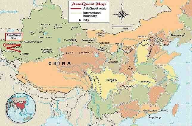
The Taklamakan Desert /ˌtæk.lə.məˈkæn/ (Chinese: 塔克拉玛干沙漠 Tǎkèlāmǎgān Shāmò, Xiao'erjing: تَاكْلامَاقًا شَاموْ; Uyghur: تەكلىماكان قۇملۇقى; Dungan: Такəламаган Шамə), also spelled "Taklimakan" and "Teklimakan", is a desert in southwest Xinjiang Uyghur Autonomous Region, northwest China. It is bounded by the Kunlun Mountains to the south, the Pamir Mountains and Tian Shan (ancient Mount Imeon) to the west and north, and the Gobi Desert to the east.
Contents
- Taklamakan desert kitaro
- The silk road 06 across the taklamakan desert
- Geography
- Climate
- Oasis
- Scientific exploration
- In popular culture
- Videography
- References
The name may be an Uyghur borrowing of the Persian tark, "to leave alone/out/behind, relinquish, abandon" + makan, "place". Some sources claimed it means "Place of No Return", more commonly interpreted as "once you get in, you'll never get out" or similar. Another plausible explanation suggests it is derived from Turki taqlar makan, describing "the place of ruins".
The silk road 06 across the taklamakan desert
Geography
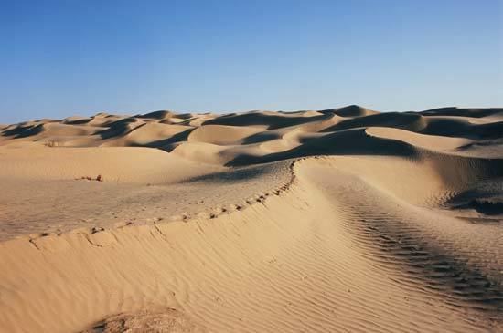
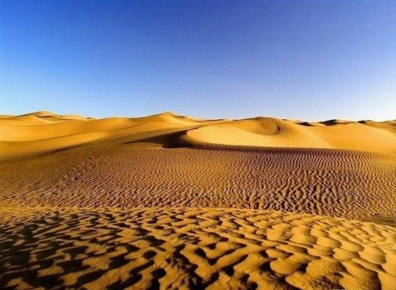
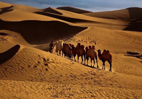
The Taklamakan Desert has an area of 337,000 km2 (130,000 sq mi), making it slightly smaller than Germany, and includes the Tarim Basin, which is 1,000 kilometres (620 mi) long and 400 kilometres (250 mi) wide. It is crossed at its northern and at its southern edge by two branches of the Silk Road as travellers sought to avoid the arid wasteland. It is the world's second largest shifting sand desert with about 85% made up of shifting sand dunes ranking 16th in size in a ranking of the world's largest deserts.
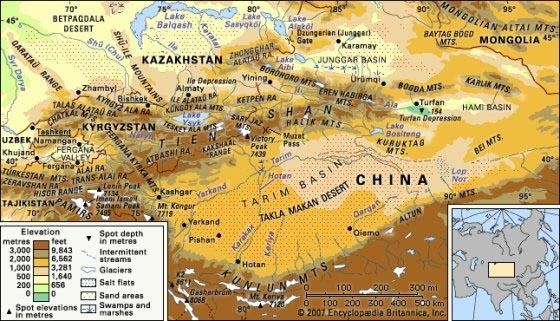
Some geographers and ecologists prefer to regard the Taklamakan Desert as separate and independent from the Gobi Desert region to its east.
The People's Republic of China has constructed two cross-desert highways. The Tarim Desert Highway links the cities of Hotan (on the southern edge) and Luntai (on the northern edge), and the Bayingol to Ruoqiang road crosses the desert to the east. In recent years, the desert has expanded in some areas, its sands enveloping farms and villages as a result of desertification.
Climate
Because it lies in the rain shadow of the Himalayas,Taklamakan is a paradigmatic cold desert climate. Given its relative proximity with the cold to frigid air masses in Siberia, extreme lows are recorded in wintertime, sometimes well below −20 °C (−4 °F), while in summer they can rise up to 40 °C (104 °F). During the 2008 Chinese winter storms episode, the Taklamakan was reported to be covered, for the first time in its history, entirely with a thin layer of snow reaching 4 centimetres (1.6 in), with a temperature of −26.1 °C (−15 °F) in some observatories.
Its extreme inland position, virtually in the very heartland of Asia and thousands of kilometres from any open body of water, accounts for the cold character of its nights even during summertime.
Oasis
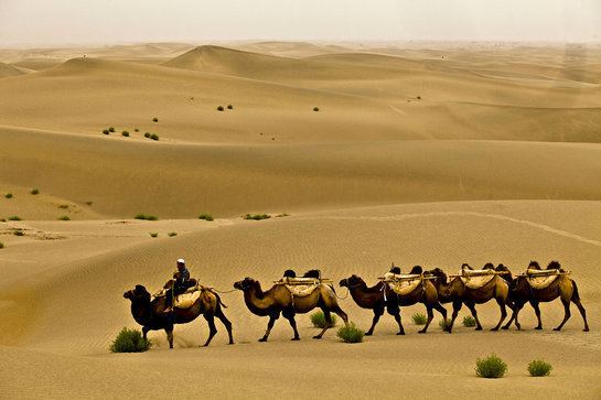
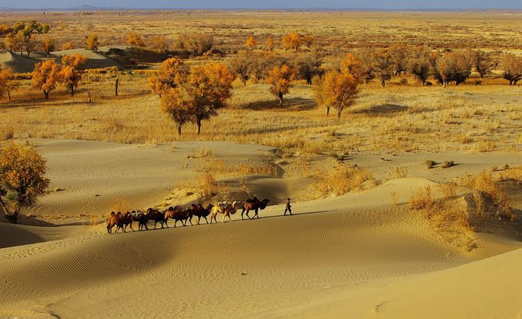
The Taklamakan Desert has very little water; therefore it is hazardous to cross. Merchant caravans on the Silk Road would stop for relief at the thriving oasis towns. It was in close proximity to many of the ancient civilizations — to the Northwest is the Amu Darya basin, to the southwest the Afghanistan mountain passes lead to Iran and India, to the east is China, and even to the north ancient towns such as Almaty can be found.
The key oasis towns, watered by rainfall from the mountains, were Kashgar, Marin, Niya, Yarkand, and Khotan (Hetian) to the south, Kuqa and Turpan in the north, and Loulan and Dunhuang in the east. Now, many, such as Marin and Gaochang, are ruined cities in sparsely inhabited areas in the Xinjiang Autonomous Region of the People's Republic of China.
The archaeological treasures found in its sand-buried ruins point to Tocharian, early Hellenistic, Indian, and Buddhist influences. Its treasures and dangers have been vividly described by Aurel Stein, Sven Hedin, Albert von Le Coq, and Paul Pelliot. Mummies, some 4000 years old, have been found in the region.
Later, the Taklamakan was inhabited by Turkic peoples. Starting with the Han Dynasty, the Chinese sporadically extended their control to the oasis cities of the Taklamakan Desert in order to control the important silk route trade across Central Asia. Periods of Chinese rule were interspersed with rule by Turkic, Mongol and Tibetan peoples. The present population consists largely of Turkic Uyghur people and ethnic Han people.
Scientific exploration
This desert was explored by several scientists as Xuanzang, a monk in the 7th century and by the archaeologist Aurel Stein in the 20th century.
Studies of atmospheric dust particles and impact on rainfall in the Western United States has found that dust, that is very water droplet forming, comes from the Taklamakan Desert. This dust moves across China and because of the type of K-Feldspar that makes up the dust particles, it is susceptible to atmospheric pollution which reduces the ability to hold water droplet formation. Further the dust from the Taklamakhan has been redistributing mineralization via rainfall to the western U.S.A. 18.
In popular culture
The desert is the main setting for Chinese film series Painted Skin and Painted Skin: The Resurrection. The Chinese TV series Candle in the Tomb (TV series) is mostly spent in this desert as they are searching for the ancient city of Jinjue (see Niya (Tarim Basin).)
The desert has been also mentioned in Japanese manga The Doraemons, as the gang travels to the desert finding the missing "Mirage Kingdom".