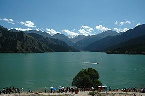
Mountains Bogda Peak | Country China | |
 | ||
Similar Ayding Lake, Heavenly Lake of Tianshan, Grape Valley, Jiaohe Ruins, Emin Minaret | ||
The Bogda Shan (Mongolian: Богд Уул, Bogd Uul, simplified Chinese: 博格达山; traditional Chinese: 博格達山; pinyin: Bógédá shãn) range is part of the eastern Tian Shan mountains, and located in Xinjiang, some 60 km east of Ürümqi. The highest elevation is Bogda Feng, at 5,445 m.
Map of Bogda Shan, Qitai, Changji, China
Administratively, the range forms the border between Dabancheng District to the south and Fukang City and Jimsar County to the north. In all three units, irrigated agriculture is based on the water flowing in streams that starts in the Bogda Shan.
References
Bogda Shan Wikipedia(Text) CC BY-SA
