
Length 544.5 km | ||
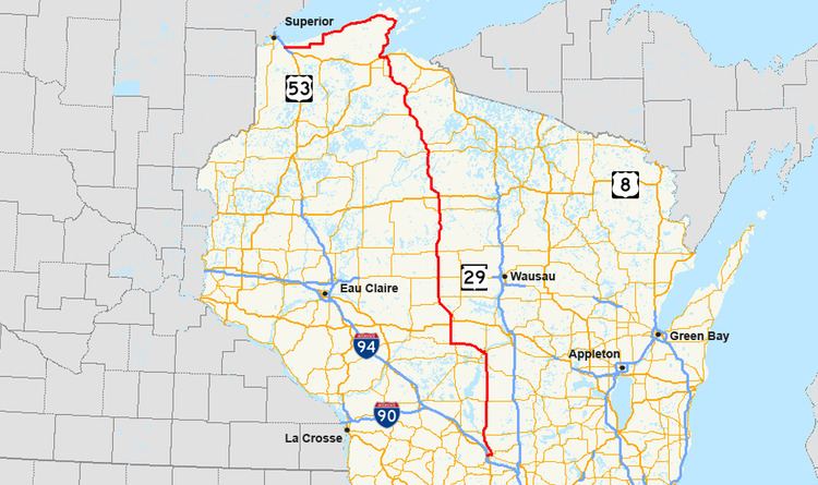 | ||
State Trunk Highway 13 (often called Highway 13, STH 13 or WIS 13) is a Wisconsin state highway running north–south across northwest and central Wisconsin. WIS 13 serves as a major north–south route connecting the communities of Wisconsin Dells, Wisconsin Rapids, Marshfield and Ashland. Highway 13 is part of the Lake Superior Circle Tour from its northern/western terminus to Ashland at is eastern junction with U.S. Highway 2. The road also provides access to the Apostle Islands National Lakeshore off the Lake Superior shoreline at Bayfield. The highway is two-lane surface road with the exception of various urban multilane road sections.
Contents
Wisconsin Dells to Marshfield
WIS 13 begins at I-90 / I-94 and passes east through Wisconsin Dells as an urban multilane highway, crossing US 12 and merging with WIS 16 and WIS 23 east through the city. WIS 13 then turns north, while WIS 23 heads east and WIS 16 heads south one mile (1.6 km) east of the city. WIS 13 follows the Wisconsin River north through Adams County, passing through Plainville, Adams and Friendship. The highway then crosses WIS 21 three miles (5 km) north of Friendship and finally passes through Cottonville, Big Flats and Rome before entering Wood County.
In Wood County, WIS 13 crosses WIS 73 at four miles (6 km) east of Nekoosa before entering Wisconsin Rapids. WIS 13 joins WIS 54 south at the Riverview Expressway, a short bypass of the downtown area. The two highways split two miles (3 km) west of their join point and WIS 13 merges with WIS 73 north. At the junction with WIS 34, WIS 73 turns westerly via W. Grand Ave, and WIS 13 continues due northerly concurrent with WIS 34 for approximately 12 miles before interchanging with the US 10 freeway 3 miles west of Junction City at Exit 204. There, WIS 13 turns to follow US 10 west toward Marshfield, following the US 10 expressway bypassing Milladore, Blenker, and Auburndale. At Exit 186 (CTH A/Veterans Pkwy) on the south side of Marshfield, WIS 13 exits the US 10 expressway to head north into Marshfield on Veterans Pkwy. WIS 13 enters Marathon County after passing through Marshfield.
The 4-lane road in Marshfield is also known as Veterans Parkway. This section was built to alleviate congestion in downtown Marshfield along Central Ave. Further, the city and WisDOT are reconstructing Central Avenue in 2009 before handing it over to city control.
Marshfield to Ashland
WIS 13 heads northwest to Spencer where it turns north to follow the Marathon/Clark county line, passing through Unity, Colby and Abbotsford (where it junctions with WIS 29) and around Dorchester. The highway then enters Taylor County where it passes through Stetsonville and crosses WIS 64 on the east side of Medford. North of Medford, WIS 13 meanders around Whittlesey, Chelsea and Westboro. The highway enters Price County two miles (3 km) north of Westboro.
In Price County, WIS 13 reaches the WIS 86 terminus at Ogema and crosses US 8 near Prentice. The highway then turns northwest to Phillips. The route turns north again out of Phillips to head into Fifield where WIS 70 crosses. WIS 13 then meets WIS 182 at its terminus in Park Falls before heading northwest out of the county into Ashland County. WIS 13 passes through Butternut and Glidden upon entering the county. Two miles northwest of Glidden, the highway joins with WIS 77 north and the two highways head north, passing through Cayuga and split with WIS 77 heading east at Mellen and WIS 13 heading northwest, passing through Highbridge, Minersville and Marengo. WIS 13 then heads north to Ashland and joins US 2 west for two miles (3 km) and then turns north (as US 2 continues west) along the Lake Superior shorline in Bayfield County
Along the Lake Superior shoreline (Ashland to Superior)
WIS 13 closely follows the shore of Chequamegon Bay and passes through Barksdale, Washburn and Bayfield. It is at Bayfield where access to Madeline Island and the Apostle Island National Lakeshore is available. WIS 13 turns westward at Red Cliff and follows the shore of Lake Superior, passing through Cornucopia, Herbster, and Port Wing, before entering Douglas County. One mile after the county line, WIS 13 turns southward to parallel the Brule River State Forest for five miles (8 km), then turns west again. The highway ends at US 2 and US 53 southeast of Superior.
History
With some variation due to realignments over time, the original 1918 routing this highway followed much of today's STH 13, beginning at what was then Kilbourn (present-day Wisconsin Dells), travelling north through Adams, Grand Rapids (now Wisconsin Rapids), Marshfield, Prentice and Ashland, ending in Bayfield. It was later that STH 13 was routed around the Bayfield Peninsula and westerly to just before Superior. STH 13 ends in the Town of Parkland at CTH Z.
The route of STH 13 previously ran the length of the state from Beloit on the Illinois state line to the Minnesota state line. From Beloit, Highway 13 followed the roads that are now U.S. Highway 51, U.S. Highway 14, U.S. Highway 12 through Janesville and Madison. Additionally, STH 13 was extended westerly from Bayfield first to Port Wing, then into Superior then across the border to Duluth. In the 1920s, The southern end of highway 13 was realigned from Evansville to Beloit along what is now WIS 213 after US 14 was commissioned.
Highway 13 was truncated to its present southern terminus in 1961 after I-90 and I-94 were commissioned.
As of late August 2012, WIS 13 was removed as a concurrency with WIS 73 between Wisconsin Rapids and Marshfield. WIS 13 now departs Wisconsin Rapids concurrent with WIS 34 to the new US 10 expressway west of Junction City, and then follows the new US 10 west to Marshfield.
Special routes
Two special routes exist for WIS 13. The first, in Wisconsin Rapids, runs downtown from Riverview Expressway (WIS 13 and WIS 54) along North 8th Street, then west along Avon Street, Jackson Street and West Grand Avenue, ending at the junction of WIS 34, WIS 13 and WIS 73. The second, in Marshfield, follows the old alignment of WIS 13 along Central Avenue through downtown.