
FIPS code 55-83525 Elevation 211 m Local time Saturday 8:06 PM | Time zone Central (CST) (UTC-6) GNIS feature ID 1576230 Population 2,098 (2013) Area code(s) 715 & 534 | |
 | ||
Weather 19°C, Wind SW at 13 km/h, 38% Humidity Area 15.98 km² (10.1 km² Land / 5.879 km² Water) | ||
Washburn is a city in Bayfield County, in the U.S. state of Wisconsin. The population was 2,117 at the 2010 census. The city is just east of and adjacent to the Town of Washburn. It is in northern Wisconsin, on the shore of Lake Superior's Chequamegon Bay.
Contents
Map of Washburn, WI, USA
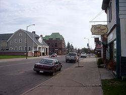
Wisconsin Highway 13 serves as a main arterial route in the community.
History
Founded in 1883, the city was named for Cadwallader C. Washburn, Republican governor of Wisconsin from 1872 until 1874.
Geography
Washburn is located at 46°40′26″N 90°53′51″W (46.673989, -90.897674).
According to the United States Census Bureau, the city has a total area of 6.17 square miles (15.98 km2), of which, 3.90 square miles (10.10 km2) is land and 2.27 square miles (5.88 km2) is water.
2010 census
As of the census of 2010, there were 2,117 people, 934 households, and 531 families residing in the city. The population density was 542.8 inhabitants per square mile (209.6/km2). There were 1,070 housing units at an average density of 274.4 per square mile (105.9/km2). The racial makeup of the city was 88.4% White, 0.8% African American, 5.9% Native American, 0.3% Asian, 0.6% from other races, and 4.1% from two or more races. Hispanic or Latino of any race were 1.6% of the population.
There were 934 households of which 26.8% had children under the age of 18 living with them, 42.5% were married couples living together, 9.9% had a female householder with no husband present, 4.5% had a male householder with no wife present, and 43.1% were non-families. 38.3% of all households were made up of individuals and 16.9% had someone living alone who was 65 years of age or older. The average household size was 2.15 and the average family size was 2.82.
The median age in the city was 45.9 years. 21.6% of residents were under the age of 18; 6.3% were between the ages of 18 and 24; 21.1% were from 25 to 44; 32.2% were from 45 to 64; and 18.8% were 65 years of age or older. The gender makeup of the city was 48.7% male and 51.3% female.
2000 census
As of the census of 2000, there were 2,280 people, 938 households, and 589 families residing in the city. The population density was 581.5 people per square mile (224.6/km²). There were 1,004 housing units at an average density of 256.1 per square mile (98.9/km²). The racial makeup of the city was 92.06% White, 0.18% Black or African American, 5.61% Native American, 0.44% Asian, 0.35% from other races, and 1.36% from two or more races. Hispanic or Latino of any race were 0.66% of the population. 26.8% were of German, 14.2% Norwegian, 7.1% French, 7.1% Polish, 6.7% Irish, 5.6% English and 5.5% Swedish ancestry according to Census 2000.
There were 938 households out of which 33.0% had children under the age of 18 living with them, 45.0% were married couples living together, 13.1% had a female householder with no husband present, and 37.2% were non-families. 33.2% of all households were made up of individuals and 13.5% had someone living alone who was 65 years of age or older. The average household size was 2.33 and the average family size was 2.97.
In the city, the population was spread out with 26.6% under the age of 18, 6.2% from 18 to 24, 25.8% from 25 to 44, 25.2% from 45 to 64, and 16.1% who were 65 years of age or older. The median age was 40 years. The ratio of Males to Females is typical of a small town, which is dece. For every 100 females there were 92.2 males. For every 100 females age 18 and over, there were 89.5 males.
The median income for a household in the city was $33,257, and the median income for a family was $40,781. Males had a median income of $31,875 versus $23,235 for females. The per capita income for the city was $15,331. About 7.5% of families and 10.3% of the population were below the poverty line, including 12.3% of those under age 18 and 6.4% of those age 65 or over.
Economy
Initially, the city's economy was based on lumbering, with sawmills lining the busy waterfront. In 1905, the DuPont company opened an explosives plant just outside town, providing an important source of employment as timber resources were growing scarce. The closing of the DuPont plant in 1971 was a severe blow to the local economy.
Currently, the city's economy focuses on the tourist industry and its position as county seat.
Local media
Washburn receives three radio stations from Ashland; WATW, WBSZ and WJJH. Television stations come from the Duluth–Superior market; KDLH, KBJR, WDSE and WDIO.