
Country United States State California Mayor Osby Davis | Population 118,837 (2013) Area 49.5 sq mi Founded 1851 | |
Points of interest Six Flags Discovery Kingdom, Mare Island, Medusa, Superman: Ultimate Flight, V2: Vertical Velocity | ||
Unemployment rate 8.9% (Feb 2015) | ||
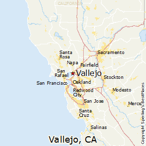
Map of Vallejo, California
Vallejo ( ; Spanish: [baˈʎexo]; Tagalog: [balˈjɛho]) is a waterfront port city in Solano County, California, located in the North Bay region of the San Francisco Bay Area. Vallejo is geographically the closest North Bay city to the inner East Bay, so it is sometimes mistakenly associated with that region. The population was 115,942 at the 2010 census. It is the tenth most populous city in the San Francisco Bay Area, and the largest in Solano County. Vallejo sits on the northeastern shore of San Pablo Bay, 30 miles north of San Francisco. The city is named after General Mariano Guadalupe Vallejo, a native Californio, leading proponent of California's statehood, and one of the first members of the California State Senate; the neighboring city of Benicia is named for his wife, Francisca Benicia Carrillo de Vallejo.
Contents
- Map of Vallejo California
- City of vallejo featured on today in america tv with terry bradshaw
- Bay village apartments for rent in vallejo ca
- Geography and environment
- Climate
- 2010
- 2000
- History
- Zodiac Killer
- Gay and lesbian community
- Artist migration
- November 2007 mayoral election
- Bankruptcy
- Participatory budgeting
- Diversity
- Economy
- Public high schools
- Public middle schools
- Private and parochial schools
- Alternative schools
- Post secondary education
- Golf courses
- Breweries
- Museums and attractions
- Sailing and boating
- Local events
- West Vallejo
- East Vallejo
- North Vallejo
- South Vallejo
- Mare Island
- Government
- County state and federal representation
- Celebrities
- Media
- Sister cities
- Mexican restaurant mexican food in vallejo ca 94590
- Rex navarette filipinos love junk food
- References
Vallejo is home to the Six Flags Discovery Kingdom theme park, the now-defunct Mare Island Naval Shipyard, and the regional office for Region 5 of the United States Forest Service. The colleges and universities in Vallejo are California Maritime Academy, the Vallejo Center campus of Solano Community College, and Touro University California.
Vallejo's public transit includes the San Francisco Bay Ferry, which regularly runs from downtown Vallejo, on the southern end of the Napa River to the San Francisco Ferry Building in San Francisco. SolTrans buses carry passengers around the cities of Vallejo and Benicia, as well as offer express services to Fairfield, California, and Bay Area Rapid Transit stations in El Cerrito, California and Walnut Creek, California.
Vallejo has twice served as the capital of the state of California: once in 1852 and again in 1853, both periods being brief. The State Capitol building burned to the ground in the 1880s and the Vallejo Fire Department requested aid from the Fire Department at Mare Island Naval Shipyard. As there were no bridges at that time, the Mare Island Fire Department had to be ferried across the Napa River, arriving to find only the foundation remaining. This was the first recorded mutual aid response in the state of California.
Vallejo is best known for the Zodiac Killer, as well as being the hometown of Bay Area rappers E-40 and Mac Dre.
City of vallejo featured on today in america tv with terry bradshaw
Bay village apartments for rent in vallejo ca
Geography and environment
According to United States Census Bureau, the city has a total area of 49.5 square miles (128 km2). Land area is 30.7 square miles (80 km2), and 18.9 square miles (49 km2) (38.09%) is water. The Napa River flows until it changes into the Mare Island Strait in Vallejo which then flows into the San Pablo Bay.
Vallejo is located on the southwestern edge of Solano County, California in the North Bay region of the San Francisco Bay Area in Northern California. Vallejo is accessible by Interstate 80 between San Francisco and Sacramento, and is the location for the northern half of the Carquinez Bridge. It is also accessible by Interstate 780 from neighboring Benicia to the east, and by Route 37 from Sonoma to the west. Route 29 (former U.S. Route 40) begins in the city near the Carquinez Bridge and travels north through the heart of the city and beyond into Napa County, entering neighboring American Canyon and eventually Napa.
Several faults have been mapped in the vicinity of Vallejo. The San Andreas Fault and Hayward Faults are the most active faults, although the San Andreas is at some distance. Locally, the Sulphur Springs Valley Thrust Fault and Southampton Fault are found. No quaternary seismic activity along these minor faults has been observed with the possible exception of a slight offset revealed by trenching. The Sulphur Mountain and Green Valley faults have been associated with the Concord Fault to the south. The Concord Fault is considered active. Historically there have been local cinnabar mines in the Vallejo area. The Hastings Mine and St. John's Mine contribute ongoing water contamination for mercury; furthermore, mine shaft development has depleted much of this area's spring water. Both Rindler Creek and Blue Rock Springs Creek have been affected.
The city of Vallejo is located 30 miles northeast of San Francisco, 22 miles north of Oakland, 56 miles north of San Jose and 52 miles south of Sacramento. Vallejo borders the city of Benicia to the east, American Canyon and the Napa county line to the north, the Carquinez Strait to the south and the San Pablo Bay to the west.
Climate
Vallejo has a mild mediterranean climate that is a mix between the cooler coastal climate and the hotter-summer interior areas. Vallejo is influenced by its position on the east shore of San Pablo Bay, but is less sheltered from inland heatwaves than areas directly on or nearer the Pacific such as San Francisco and Oakland. Although slightly less marine, average temperatures range between 8 °C (46 °F) in January and 19.8 °C (67.6 °F) in July. However, summer is very long with July–September being almost equal in historical average temperatures. This seasonal lag sees October averages being higher than in May in spite of it being after the Equinox (meaning less daylight than darkness).
2010
The 2010 United States Census reported that Vallejo had a population of 115,942. The population density was 2,340.3 people per square mile (903.6/km²). The racial makeup of Vallejo was 38,066 (32.9%) White, 25,572 (22.1%) African American, 757 (0.7%) Native American, 28,895 (24.9%) Asian (21.1% Filipino, 1.0% Indian, 0.9% Chinese, 0.5% Vietnamese, 0.2% Japanese, 0.2% Korean, 0.1% Laotian), 1,239 (1.1%) Pacific Islander, 12,759 (11.0%) from other races, and 8,656 (7.5%) from two or more races. Hispanic or Latino of any race were 26,165 persons (22.6%). Non-Hispanic Whites numbered 28,946 persons (25.0%).
The Census reported that 114,279 people (98.6% of the population) lived in households, 1,130 (1.0%) lived in non-institutionalized group quarters, and 533 (0.5%) were institutionalized.
There were 40,559 households, out of which 14,398 (35.5%) had children under the age of 18 living in them, 17,819 (43.9%) were opposite-sex married couples living together, 7,214 (17.8%) had a female householder with no husband present, 2,755 (6.8%) had a male householder with no wife present. There were 2,804 (6.9%) unmarried opposite-sex partnerships, and 497 (1.2%) same-sex married couples or partnerships. 9,870 households (24.3%) were made up of individuals and 3,255 (8.0%) had someone living alone who was 65 years of age or older. The average household size was 2.82. There were 27,788 families (68.5% of all households); the average family size was 3.36.
The population was spread out with 26,911 people (23.2%) under the age of 18, 11,667 people (10.1%) aged 18 to 24, 30,053 people (25.9%) aged 25 to 44, 33,312 people (28.7%) aged 45 to 64, and 13,999 people (12.1%) who were 65 years of age or older. The median age was 37.9 years. For every 100 females there were 94.3 males. For every 100 females age 18 and over, there were 91.4 males.
There were 44,433 housing units at an average density of 896.9 per square mile (346.3/km²), of which 24,188 (59.6%) were owner-occupied, and 16,371 (40.4%) were occupied by renters. The homeowner vacancy rate was 3.0%; the rental vacancy rate was 9.4%. 68,236 people (58.9% of the population) lived in owner-occupied housing units and 46,043 people (39.7%) lived in rental housing units.
2000
As of the census of 2000, there were 116,760 people, 39,601 households, and 28,235 families residing in the city. The population density was 1,493.3/km² (3,867.9/mi²). There were 41,219 housing units at an average density of 527.2/km² (1,365.4/mi²). The racial makeup of the city was 35.97% White, 23.69% African American, 0.66% Native American, 24.16% Asian, 1.09% Pacific Islander, 7.88% from other races, and 6.56% from two or more races. Hispanic or Latino of any race were 15.92% of the population.
As of 2000, residents with Filipino ancestry made up 20.74% of Vallejo's population. As of 2009, Vallejo is the 9th largest city in the San Francisco Bay Area, 48th in the state of California, and 215th in the U.S. by population.
There were 39,601 households out of which 36.5% had children under the age of 18 living with them, 49.1% were married couples living together, 16.5% had a female householder with no husband present, and 28.7% were non-families. 22.7% of all households were made up of individuals and 8.0% had someone living alone who was 65 years of age or older. The average household size was 2.90 and the average family size was 3.43.
In the city, the population was spread out with 27.6% under the age of 18, 9.0% from 18 to 24, 29.6% from 25 to 44, 22.6% from 45 to 64, and 11.2% who were 65 years of age or older. The median age was 35 years. For every 100 females there were 93.9 males. For every 100 females age 18 and over, there were 89.7 males.
The median income for a household in the city was $47,030, and the median income for a family was $53,805. Males had a median income of $40,132 versus $32,129 for females. The per capita income for the city was $20,415. About 7.7% of families and 10.1% of the population were below the poverty line, including 12.2% of those under age 18 and 8.9% of those age 64 or over.
History
Vallejo was once home of the Coastal Miwok as well as Suisunes and other Patwin Native American tribes. The Columbus Parkway EIR documents three confirmed Native American sites located in the rock outcrops in the hills above Blue Rock Springs Park. The California Archaeological Inventory has indicated that the three Indian sites are located on Sulphur Springs Mountain.
The city of Vallejo was once part of the 84,000-acre (340 km2) Rancho Suscol Mexican land grant of 1843 by Governor Manuel Micheltorena to General Mariano Guadalupe Vallejo. The city was named after this Mexican military officer and title holder who was appointed in settling and overseeing the north bay region. General Vallejo was responsible for military peace in the region and founded the pueblo of Sonoma in 1836. In 1846 independence-minded Anglo immigrants rose up against the Mexican government of California in what would be known as the Bear Flag Revolt which resulted in his imprisonment in Sutter's Fort. This was subsequently followed by the annexation of the California Republic to the United States. General Vallejo, though a Mexican army officer, generally acquiesced in the annexation of California to the United States, recognizing the greater resources of the United States and benefits that would bring to California. He was a proponent of reconciliation and statehood after the Bear Flag Revolt, and has a U.S. Navy submarine, the USS Mariano G. Vallejo (SSBN-658), named after him.
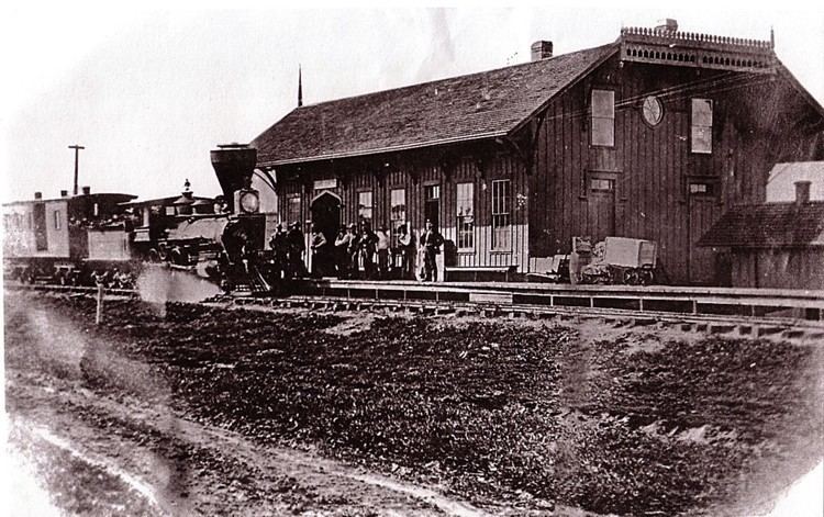
In 1850, Vallejo proposed plans for a new city, to be called Eureka, with the capitol, university, botanical garden and other features. After a statewide referendum, his proposal was accepted, although a new name was decided upon: Vallejo. In 1851, a commission appointed by the Senate found a site on a hill that overlooked the bay and could see San Francisco on a clear day, and it was approved for its symbolic strategic value. In 1851, Vallejo was the official state capitol, with the government prepared to meet for the first time the following year. In 1852, the legislature convened for the first time. Unfortunately, Vallejo didn't follow through with building a capitol for them to meet in. After being forced to meet in a leaky building, sitting on barrels, they motioned to move sessions to Sacramento, and served there for the remainder of the session after only 11 days. In 1853, it was again the meeting place for the legislature, solely for the purpose of moving the capitol officially to Benicia, which occurred on February 4, 1853, after only a month. Benicia is named after Vallejo's wife, Francisca Benicia Carrillo. After legislature left, the government established a naval shipyard on Mare Island, which helped the town overcome the loss. The yard functioned for over a hundred years, finally closing in 1996.
The U.S. government appointed the influential Vallejo as Indian agent for Northern California. He also served on the state constitutional convention in 1849. Afterward, Vallejo remained active in state politics, but challenges to his land titles around Sonoma eventually left him impoverished and reduced his ranch from 250,000 acres to a mere 300. He eventually retired from public life, questioning the wisdom of his having welcomed the American acquisition of California in the first place. Vallejo died in 1890, a symbol of the eclipse of Californio wealth, power, and prestige.
Although the town is named after General Vallejo, the man regarded as the true founder of Vallejo is John B. Frisbie. After his daughter Epifania married Frisbie, General Vallejo granted him power of attorney for the land grant. It was Frisbie who hired E.H. Rowe, the man who designed the city layout and who named the east-west streets after states and the north-south streets after California counties.
In the early 1900s, Vallejo was home to a Class D minor-league baseball team, referred to in local newspapers sometimes as the "Giants" and other times simply as "The Vallejos." Pacific Coast League star and future Chicago White Sox center fielder Ping Bodie played for Vallejo during the 1908 season, in which the team reached the California state title game. The team was disbanded in the early 1920s. Today it is home to the Vallejo Admirals of the independent Pacific Association.
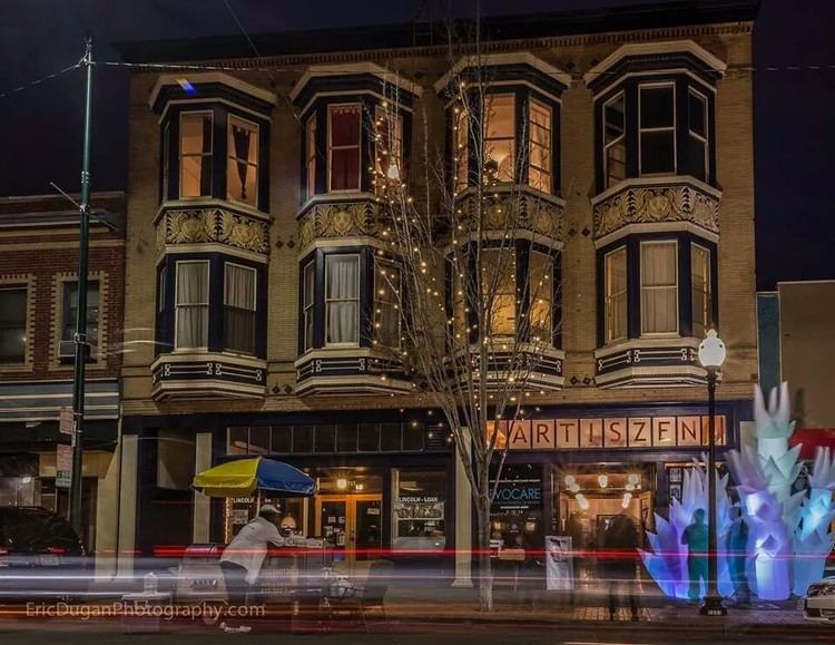
Downtown Vallejo retains many of its historic Victorian and Craftsman homes.
Zodiac Killer
The Zodiac Killer was a serial killer who was active in Northern California during the 1960s. He claimed to have killed 37, but the actual number is unknown. Three of the murders attributed to the Zodiac Killer took place within the city limits or nearby. Both the Vallejo Police Department and San Francisco Police Department investigated the murders but were never able to solve the case. The case was marked inactive in April 2004 but was reopened in March 2007. The Vallejo Police Department website has a menu tab for providing Zodiac Crime Tips. The case also remains open in additional jurisdictions.
Gay and lesbian community
As early as the 1940s and before, Vallejo is known to have had a well-formed gay community, which was a short drive or boat ride away from San Francisco. At one time Vallejo boasted eight gay bars. After a migration of gays and lesbians from San Francisco in the decade 2000-2009, openly gay members of the community encountered what they described as a backlash against them. The school district was threatened by the ACLU to be sued for harassment of a 17-year-old lesbian by school administrators. The school settled the lawsuit with the student. The school agreed to pay her $25,000, adopt a more stringent non-discrimination policy and include a curriculum that positively portrayed gay and lesbian people. Some candidates for public office were alarmed by the formation of a "faith community" coalition organized by a group of local churches, formed under the name "Vallejo Faith Organization." The coalition sought to represent the values and interest of Christians in local politics and to help facilitate the church's involvement in bettering the community of Vallejo. A few of these churches have partnered with a group known as the "New Apostolic Reformation," or NAR, to declare Vallejo as a "City of God."
In 2009, Osby Davis answered a question in an interview with New York Times columnist Scott James (who writes fiction under the pen name Kemble Scott) by saying that according to Davis's personal belief and understanding of the Bible gay people would not get into heaven.
Osby Davis claimed his comments were taken out of context. The New York Times released the interview with Davis. The parts the New York Times did not originally report were portions where Davis compared the LGBT community to thieves, murderers, liars, drug addicts and child molesters. Many within the community saw his comments as divisive and bigoted and demanded that he step down. Many other residents of Vallejo agreed with his comments and offered their full support. Many who opposed his comments felt this showed the supposed intolerance of the LGBT community in Vallejo by the so-called "faith" community. In the next election in November 2011, Osby Davis was re-elected mayor of Vallejo.
Two openly gay men have been elected to Vallejo's city council.
Artist migration
In recent years, Vallejo has attracted a large community of artists to the region in search of lower rent and larger work-spaces. Artists pushed out of larger Bay Area cities like San Francisco and Oakland have been working with city leaders to revitalize the once blighted downtown area. The artist-ran Vallejo Art Walk scheduled on the second Friday of every month in downtown Vallejo has been recognized as a hub for artists in the Bay Area and the entirety of California.
November 2007 mayoral election
The incumbent mayor was former city council member Anthony Intintoli; Florence Douglas was the first female Mayor in Vallejo.
Bankruptcy
On May 6, 2008, the City Council voted 7–0 to file for Chapter 9 bankruptcy, at the time becoming the largest California city to do so. Stephanie Gomes, Vallejo City Councilwoman, largely blames exorbitant salaries and benefits for Vallejo firefighters and police officers. Reportedly, salaries and benefits for public safety workers account for at least 80 percent of Vallejo's general fund budget. (Stockton filed for bankruptcy in June 2012.)
On November 1, 2011, a federal judge released Vallejo from bankruptcy after nearly three years. The city is now taking measures to find more revenue, and has already gotten new employee contracts, lowered pension plans for firefighters, increased the amount city staffers add to their health insurance and eliminated minimum staffing requirements for the fire department. The legal fees included in bankruptcy cost the city $8 million.
A brief analysis of Vallejo's financial downfall is featured in Michael Lewis' book Boomerang: Travels in the New Third World.
Participatory budgeting
On April 17, 2012, the City Council approved the first citywide participatory budgeting (PB) process in the United States. The Council allocated $3.4 million to the Vallejo PB process and since then, Vallejo residents and business and property owners have been developing and designing project ideas. They have vetted and reduced more than 800 project ideas to 36 projects that will be on the ballot. Vallejo residents 14 years of age and older will vote and choose six out of 36 projects to vote on from May 11 through May 18, 2013.
The second cycle of participatory budgeting in Vallejo was initiated on February 4, 2014, with $2.4 million allocated. A public vote open to all residents of Vallejo age 16 and over took place in October 2014.
Diversity
Vallejo is the most diverse city of any size in the United States.
Economy
According to the City's 2009 Comprehensive Annual Financial Report, the top employers in the city are:
Public high schools
Public middle schools
Private and parochial schools
Alternative schools
Post-secondary education
Golf courses
Breweries
Museums and attractions
Sailing and boating
Local events
West Vallejo
West Vallejo is the oldest and most historic section of the city, and stretches from Interstate 80 and Sonoma Blvd. to Mare Island and the Vallejo waterfront. In old town Vallejo, East-West streets are named after USN battleships (named after states), North-South streets are named after counties, and alleys between East-West streets are named after old, defunct car companies. The order of East-West streets appears at first to be random but actually follows the commissioning order of USN battleships. Names are sometimes truncated. For example, there is a Carolina Street (not a North and a South) and a York Street (omitting the "New").
The downtown and waterfront areas, located in West Vallejo near Mare Island were undergoing extensive transformation and development as many people from San Francisco move to the Victorian homes downtown. Due to the city declaring bankruptcy, many projects stalled. However, a large parking structure to accommodate the ferry and bus system was recently completed and is expected to redraw attention to Vallejo's old town on the west side.
The city's three historic neighborhoods are in West Vallejo:
This subdivision, originally named the "Georgetown" was renamed the "Bay Terrace" in 1920. It is a district composed of 126 individual buildings, designed by architect George W. Kelham (a student of Frederick Law Olmsted, architect of Golden Gate Park, Central Park and the "Emerald Necklace" in Boston) and constructed by the United States Housing Corporation in 1918 as the permanent component of Project 581, to provide housing for Mare Island Naval Shipyard workers during World War I.
This project was one of only two such projects on the Pacific Coast. The district has a remarkably high degree of integrity. Most of the original residential buildings remain; almost two-thirds of them have survived in their original condition. The residential buildings are detached single-family houses, semi-detached two-family houses and semi-detached two-flat houses, distributed fairly evenly along the street. A sense of individuality among the houses was achieved by using fifteen variations on six basic plans, while visually harmonious streetscapes were created through the use of the Colonial Revival style. This distinctive architectural style of the housing visually distinguished the boundaries of the Bay Terrace district from the surrounding neighborhood. Although the subdivision is not currently on the National Register of Historic Places, it does meet the "significant" requirements under criteria A and C for evaluation.
East Vallejo
East Vallejo is the largest and most populated, containing newer neighborhoods of the city, which has undergone considerable growth since the late 1940s. East Vallejo begins on the east side of Interstate 80 and includes the "manor neighorhoods" such as Tennessee and Steffan Manor, Silverview, Skyview Terrace, Granada Hills, Greenmont, Somerset Highlands, and Northgate neighborhood near Blue Rock Springs Park. In the northeast corner of Vallejo is the Hiddenbrooke community, centered around Hiddenbrooke Golf Club. East Vallejo is generally considered to be the safest section of the city.
North Vallejo
North Vallejo, located near Highway 37, has a number of housing subdivisions including the tracts of Lofas-Lakeside, College Park, College Hills, and Country Club Crest (which gained prominence as "Crest Side" through recordings by Mac Dre). One of the city's largest government subsidized housing projects - Chabot Terrace - was located here during the war years of the 1940s. The Lofas-Lakeside housing tract, built in the early 1950s, was the first African American housing subdivision in Vallejo. It was built by building contractor B. W. Williams at the request of a group of African American couples seeking home ownership.
South Vallejo
South Vallejo is located south of York and Marin Streets and is sometimes known as "Hillside", the "Su side", or "Beverly Hills". South Vallejo is famous for being the birthplace of the famous Vallejo rap group, The Click, as well as E-40's record label Sick Wid It Records.
The southeast area of Vallejo includes Glen Cove, a neighborhood located where Interstates 80 and 780 meet, near Benicia. It boasts views of the Carquinez Strait, including the newly built westbound Carquinez Bridge. Most of the home construction in this area was completed in the 1980s but includes some of the most expensive housing in the city. Glen Cove is home to Waterfront Park or Sogorea Te as Native Americans call it.
South Vallejo also has another historic area "Sandy Beach", the first area in Vallejo to be settled. Although this area is located in South Vallejo, Sandy Beach is actually unincorporated Solano County. The houses here, located on the shore at the mouth of the Napa River, were formerly fishing shacks originally built in the 1800s. It is rumored that Jack London used to play poker at the age of 16 in the shack on the pier directly across the water. The oldest known house in Vallejo, the Winslow House, built in 1860 by a merchant marine, George Greenwood, of Maine, and in 1891 was purchased by Isaac Winslow, remains in its existing historic condition on Winslow Avenue. The property was originally 700 acres (283 ha) and is now 3/4 an acre. It is also the home of the oldest Pepper Tree in California (non-native).
South Vallejo has other historic buildings, including a rare 1869 historic mansion, the only one of its kind left in Vallejo. The Starr Mansion, named after its builder, Abraham Dubois Starr, sits on top of a hill and offers panoramic views of the city of Vallejo, the waterways of the Napa River, Mare Island and the picturesque hills to the east. The beautiful, unique architecture is Second Empire Italianate and thought of as Vallejo's diamond. Now a bed and breakfast that lodges and caters to tourists and business visitors, the mansion is filled with furniture and accessories of the period. The two adjoining parlors have matching Italian marble fireplaces and breath-taking unique gold leaf light fixtures original to the structure.
Viceland's Noisey documentary, simply titled Bay Area, features several minutes of footage recorded in South Vallejo, while interviewing South Vallejo native, Nef the Pharaoh about Bay Area Hip Hop and police brutality.
The Cal Maritime campus is located in South Vallejo and is putting in considerable effort to revitalize the area.
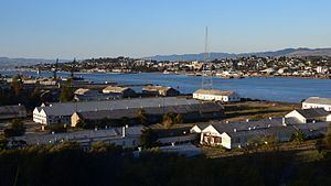
Mare Island
Mare Island, former home to the oldest Naval Base west of the Mississippi and decommissioned in 1996, has the newest homes in the city as well as some of the oldest. Touro University California is located on the south side of Mare Island. As one of the nation's oldest decommissioned shipyard and naval bases, Mare Island has a rich history and contains many National Historic Landmark buildings, including a 19th-century industrial brick warehouse, the Coal Shed Artists Studios, Officers Mansions, designated historic landscapes Alden Park and Chapel Park, the oldest golf course west of the Mississippi, and Saint Peters Chapel, a nondenominational church built in 1901 that boasts the largest collection of actual Louis Comfort Tiffany stain-glass windows on the west coast. The Island is still home to industrial and creative work spaces, currently the renown art space known as the Coalshed Studios sits on the water front at building 153. Coalshed Brewery is also on the same water front.
Government
The Government of Vallejo is defined under the Charter of the City of Vallejo. It is a council–manager government and consists of the Mayor, City Council, and numerous departments and officers under the supervision of the City Manager, such as the Vallejo Police Department, Vallejo Fire Department, Vallejo Public Works Department, and Vallejo Economic Development Department.
As of December 2016, the council consists of:
Updated (5/9/17 by W. Law)
County, state, and federal representation
Residents of Vallejo participate in the Government of Solano County and elections for Solano County Board of Supervisors districts 1 and 2 as well as the Sheriff-Coroner, District Attorney, Assessor/Recorder, Auditor-Controller, and Treasurer/Tax Collector/County Clerk. As of January 2013 these were represented by Supervisors Erin Hannigan and Linda Seifert, Sheriff-Coroner Thomas Ferrara, District Attorney Krishna Abrams, Assessor/Recorder Marc Tonnesen, Auditor-Controller Simona Padilla-Scholtens, and Treasurer/Tax Collector/County Clerk Charles Lomeli.
In the California State Legislature, Vallejo is in the 3rd Senate District, represented by Democrat Bill Dodd, and in the 14th Assembly District, represented by Democrat Tim Grayson.
In the United States House of Representatives, it's in California's 5th congressional district, represented by Democrat Mike Thompson.
Celebrities
Media
Sister cities
Vallejo has six sister cities: