
Existed: 1934 – present Constructed 1934 | Length 170.6 km | |
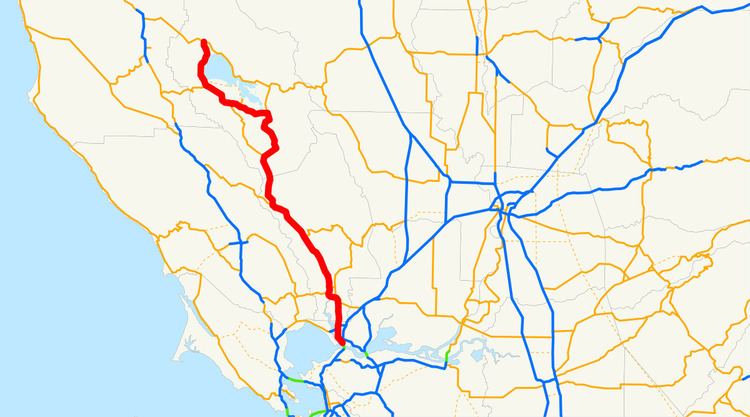 | ||
Up and down mount saint helena california state route 29
State Route 29 (SR 29) is a state highway in the U.S. state of California that travels from Interstate 80 in Vallejo north to State Route 20 in Upper Lake. It serves as the primary road through the Napa Valley, providing access to the Clear Lake region to the north and the rest of the San Francisco Bay Area to the south.
Contents
- Up and down mount saint helena california state route 29
- Map of CA 29 California USA
- Route description
- Major intersections
- References
Map of CA-29, California, USA
Route description
This route is part of the California Freeway and Expressway System south of the intersection of Oak Knoll Avenue (approximately 1 mile north of the Napa city limits), and is eligible for the State Scenic Highway System. However, it is not a scenic highway as defined by Caltrans.
SR 29 begins at Interstate 80 (I-80) just north of the Carquinez Bridge in Vallejo. After running through the downtown area of Vallejo, it travels as a four-lane expressway (on some segments, five) through American Canyon to Napa. It then briefly becomes a freeway as it passes through Napa.
The highway then runs as a two-lane road through the Napa Valley cities and towns of Yountville, Oakville, Rutherford, St. Helena, and Calistoga, while also passing many of the region's notable vineyards and wineries. This portion of the highway is often heavily congested with rental cars and tour buses in spring and summer, when tourists flock to Napa Valley.
North of Calistoga, SR 29 climbs Mount Saint Helena, an extinct volcano, at the border between Napa County and Lake County. The road then heads north to Middletown and Lower Lake before going around the southern and western sides of Clear Lake, the largest natural freshwater lake completely within California. In Lakeport, SR 29 becomes a freeway as it bypasses the city. It then reverts as a two-lane highway before it terminates at Route 20 in Upper Lake.
Historically, the route between the Napa Valley and Middletown was served by the Old Bull Trail Road, built by volunteers in the 1850s that had grades up to 35 percent. That was replaced by the St. Helena Toll Road in 1868, which had more manageable inclines of up to 12 percent. The State of California purchased the toll road in 1925.
The points of interest along Route 29 include Bothe-Napa Valley State Park, Bale Grist Mill State Historic Park, Robert Louis Stevenson State Park, the St. Helena Toll Road and Bull Trail, the Stone House, and the Lower Lake Stone Jail.
Major intersections
Except where prefixed with a letter, postmiles were measured on the road as it was in 1964, based on the alignment that existed at the time, and do not necessarily reflect current mileage. R reflects a realignment in the route since then, M indicates a second realignment, L refers an overlap due to a correction or change, and T indicates postmiles classified as temporary (for a full list of prefixes, see the list of postmile definitions). Segments that remain unconstructed or have been relinquished to local control may be omitted. The numbers reset at county lines; the start and end postmiles in each county are given in the county column.