
Existed: 1926 – present Length 1,207 km | Constructed 1926 | |
 | ||
States: | ||
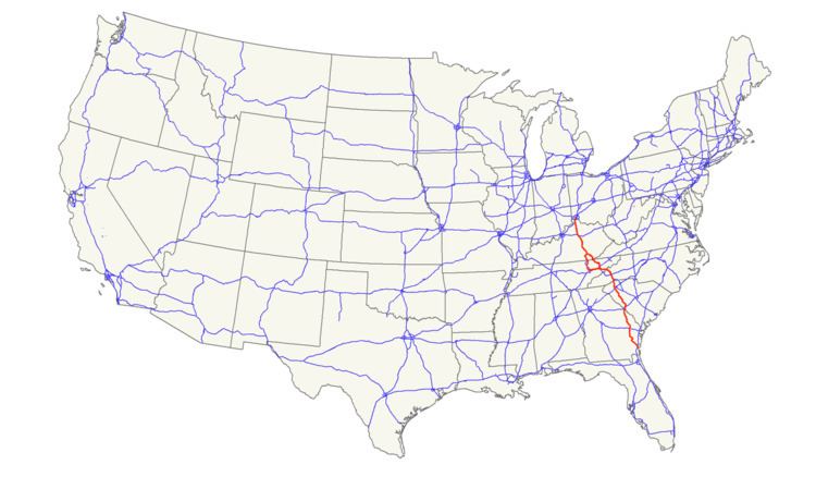
U.S. Route 25 (US 25) is a north–south United States highway that runs for 750 miles (1,210 km) from Brunswick, Georgia to the Ohio state line in Covington, Kentucky.
Contents
- Map of US 25 United States
- Georgia
- South Carolina
- North Carolina
- Tennessee
- US Route 25E
- US Route 25W
- Kentucky
- ADHS corridors
- History
- Major intersections
- References
Map of US-25, United States
Georgia
Starting at the intersection of US 17/SR 25 in Brunswick, US 25 goes northwest to Jesup then northeast to Ludowici. It then stays at a general north route through the cities of Statesboro, Millen, Waynesboro and finally Augusta, where it crosses the Savannah River into South Carolina. The overall majority of the route is four-lane.
South Carolina
Entering South Carolina from Augusta, Georgia, US 25 goes north through downtown North Augusta, connecting with I-20 just outside town. US 25 goes northwesterly through the cities of Edgefield, Greenwood, and Greenville; going due north at Travelers Rest to the North Carolina state line. Majority of the route is four-lane, with various sections at expressway grade.
North Carolina
US 25 becomes a freeway from the state line in Tuxedo, in Henderson County. It continues for 9 miles (14 km) before connecting with I-26/US 74 near East Flat Rock. Splitting from I-26/US 74 near Fletcher, it goes north through Arden, Biltmore Forest, and downtown Asheville, before reconnecting with I-26 near Woodfin. At Weaverville, US 25 and US 70 travel northwesterly together, through Marshall and Hot Springs into Tennessee.
Tennessee
In concurrency with US 70 and SR 9, US 25 enters the state through the Bald Mountains, followed by crossing the French Broad River along Wolf Creek Bridge. Along the northern bank of the French Broad River, it crosses back over and leaves the Cherokee National Forest. US 25 enters Newport, after crossing the Pigeon River, and serves as Broadway Street through the downtown area. At the western edge of Newport, US 25 splits: US 25E towards Morristown and US 25W towards Knoxville.
U.S. Route 25E
Traversing a 112.8 miles (181.5 km) from Newport, Tennessee to North Corbin, Kentucky, US 25E connects the cities of White Pine, Morristown, Bean Station, Tazewell and Harrogate in Tennessee. Entering Kentucky via the Cumberland Gap Tunnel, it connects the cities of Middlesboro and Barbourville. In North Corbin, after merging back with US 25W, a US 25E connector continues west to I-75.
U.S. Route 25W
Traversing a 145.7 miles (234.5 km) from Newport, Tennessee to North Corbin, Kentucky, US 25W goes west connecting Dandridge, Knoxville and Clinton. Going north in parallel or in concurrency with I-75, it goes through Caryville, Jacksboro, La Follette and Jellico, before crossing the Tennessee/Kentucky line. Continuing north, it goes through Williamsburg before going through downtown Corbin and then reconnecting with US 25E in North Corbin.
Kentucky
US 25 starts again in North Corbin and traverses north, in parallel with I-75, connecting the cities of London, Berea, Richmond, Lexington and Dry Ridge. US 25 ends in Covington at the Ohio state line over the Ohio River along Clay Wade Bailey Bridge; US 42/US 127 continue into Cincinnati.
ADHS corridors
US 25 overlaps with three corridors that are part of the Appalachian Development Highway System (ADHS), which is part of Appalachian Regional Commission (ARC). Passed in 1965, the purpose of ADHS is to generate economic development in previously isolated areas, supplement the interstate system, connect Appalachia to the interstate system, and provide access to areas within the Region as well as to markets in the rest of the nation.
History
US 25 was established on November 11, 1926 as part of the original United States Numbered Highway system; it was routed along the Dixie Highway, from North Augusta, South Carolina to Port Huron, Michigan, with a two divides (US 25E/US 25W) through Tennessee and Kentucky. In 1928, one divided section between Richmond and Newport, Kentucky was removed; US 25 followed the US 25W routing, while US 25E was replaced by mostly US 27. In 1929, US 25 was extended south into Georgia, ending at US 80, near Statesboro, Georgia. In 1933, US 25 was extended north from Port Huron to Port Austin, Michigan. In 1936, US 25 was extended south again to its current terminus at US 17, in Brunswick, Georgia.
In 1974, US 25 was eliminated in Ohio and Michigan, establishing its northern terminus on the Clay Wade Bailey Bridge, in Covington, Kentucky. Its former alignment was replaced by Interstate 75, between Cincinnati and Detroit, and Interstate 94 between Detroit and Port Huron. M-25 continues as the designation of former US 25 between Port Huron and Port Austin.
In 2000, US 25E was rerouted through the Cumberland Gap Tunnel (open four years prior), making a direct link between Tennessee and Kentucky, eliminating Virginia's short section. Its old alignment that went through historic Cumberland Gap was handed over to the Cumberland Gap National Historical Park, with the former roadbed through the park restored to an early 19th-century wagon path.