
- elevation 3,189 ft (972 m) Basin area 13,271 km² | - elevation 3,440 ft (1,049 m) Length 343 km | |
 | ||
Cities | ||
French broad river north carolina united states
The French Broad River flows 218 miles (351 km) from near the town of Rosman in Transylvania County, North Carolina, into the state of Tennessee. Its confluence with the Holston River at Knoxville is the beginning of the Tennessee River. The river flows through the counties of Transylvania, Buncombe, Henderson, and Madison in North Carolina, and Cocke, Jefferson, Sevier, and Knox in Tennessee, and drains large portions of the Pisgah National Forest and the Cherokee National Forest.
Contents
- French broad river north carolina united states
- Map of French Broad River United States
- Ledges river park and the french broad river
- Course
- History
- Crossings
- North Carolina
- Tennessee
- References
Map of French Broad River, United States
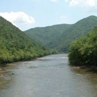
Ledges river park and the french broad river
Course
The French Broad River begins just west of the Eastern Continental Divide. From there it flows northeasterly through the Appalachian Mountains. The river follows a general northeasterly direction through Transylvania, Henderson, and Buncombe counties. In Buncombe County, the river flows through the city of Asheville, where it receives the water of the Swannanoa River. Downstream of Asheville, the river proceeds north through Madison County, where it flows through its county seat, Marshall. After passing through the mountain resort of Hot Springs in the Bald Mountains, the river enters Cocke County, Tennessee.
In Cocke County, the river passes through the community of Del Rio, and receives the waters of both the Pigeon River and the Nolichucky River northwest of Cocke's county seat, Newport. The river then enters the slack waters of Douglas Lake, which is created by the Tennessee Valley Authority's Douglas Dam in Sevier County, approximately 32 miles (51 km) upstream from the river's mouth. Near Sevierville, the French Broad River receives the flow of the Little Pigeon River, which drains much of the Tennessee section of the Great Smoky Mountains. After flowing through a wide gap in Bays Mountain, it enters Knox County. It joins the Holston River to form the Tennessee at a place known as "Forks of the River" at the eastern edge of Knoxville.
History
The French Broad River was named by European settlers centuries ago because it was one of the two broad rivers in western North Carolina. The one which flowed into land claimed by France at that time was named the "French Broad River", whereas the other, which stayed in land claimed by England – the Colony of North Carolina – was named the "English Broad River". (The latter was later renamed simply the "Broad River"). The Indigenous Americans of this area, the Cherokee Indians, called it different names: Poelico, Agiqua (broad) in the mountains, Tahkeeosteh (racing waters) from Asheville down and Zillicoah above Asheville. The French called it the Agiqua, borrowing one of the Cherokee names.
Douglas Dam, built on the lower French Broad by the Tennessee Valley Authority (TVA) during the 1940s, is one of the larger TVA developments on a tributary of the Tennessee River. (The two other very large ones are Norris Lake on the Clinch River and Cherokee Lake on the Holston River.)
In 1987, the North Carolina General Assembly established the French Broad River State Trail as a blueway which follows the river for 67 miles. The paddle trail is a part of North Carolina State Trails Program, which is a section of the NC Division of Parks and Recreation. A system of launch point locations was created along the river for the trail.
The portion of the French Broad River in Tennessee was designated a state scenic river by the Tennessee Scenic Rivers Act of 1968. Approximately 33 miles (53 km) of the river in Cocke County, starting at the North Carolina border and extending downstream to the place where it flows into Douglas Lake, are designated as a Class III, Partially Developed River.
Wilma Dykeman wrote the book The French Broad (1955) about the river. The book brought public attention to concerns about the polluted condition of parts of the river. The river is also the subject of the monograph Watershed: The French Broad River (2012) by Jeff Rich.
Crossings
The following is a partial list of crossings of the French Broad from Brevard to the confluence with the Tennessee River.