
Country Languages spoken Area 10,491.69 km2 | Region Northeast India Capital Founded 21 January 1972 Chief Minister Manik SarkarCPM Governor Padmanabha Acharya Literacy 94.65 per cent.(1st){2014}. Population 3.658 million (2012) | |
Colleges and Universities Tripura University (Agartala), National Institute of Technology Agartala (Jirania), Agartala Government Medical College (Agartala), Maharaja Bir Bikram College (Agartala), Tripura Institute of Technology (Narsingarh) | ||
Tripura is a state in Northeast India. The third-smallest state in the country, it covers 10,491 km2 (4,051 sq mi) and is bordered by Bangladesh (East Bengal) to the north, south, and west, and the Indian states of Assam and Mizoram to the east. In 2011 the state had 3,671,032 residents, constituting 0.3% of the countrys population. Indigenous communities, known in India as scheduled tribes, form about 30 per cent of Tripuras population. The Kokborok speaking Tripuri people are the major group among 19 tribes and many subtribes. The Bengali people form the ethno-linguistic majority in Tripura.
Contents
- Map of Tripura
- Agartala tripura india
- History
- Geography and climate
- Economy
- Culture
- Tripuri cuisine
- References
Map of Tripura
The area of modern Tripura was ruled for several centuries by the Tripuri dynasty. It was the independent princely state of the Tripuri Kingdom under the protectorate of the British Empire which was known as Hill Tippera while the area annexed and ruled directly by British India was known as Tippera District (present Comilla District). The independent Tripuri Kingdom (or Hill Tippera) joined the newly independent India in 1949. Ethnic strife between the Tripuri people and Bengali population led to tension and scattered violence since its integration into the country of India, but the establishment of an autonomous tribal administrative agency and other strategies have led to peace.
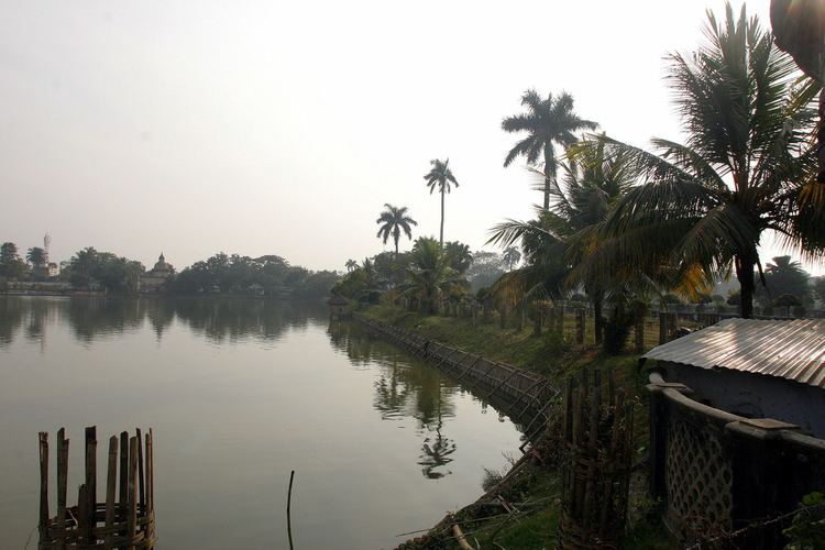
Agartala tripura india
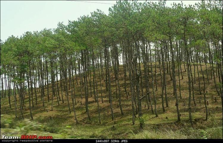
Tripura lies in a geographically disadvantageous location in India, as only one major highway, the National Highway 44, connects it with the rest of the country. Five mountain ranges—Boromura, Atharamura, Longtharai, Shakhan and Jampui Hills—run north to south, with intervening valleys; Agartala, the capital, is located on a plain to the west. The state has a tropical savanna climate, and receives seasonal heavy rains from the south west monsoon. Forests cover more than half of the area, in which bamboo and cane tracts are common. Tripura has the highest number of primate species found in any Indian state. Due to its geographical isolation, economic progress in the state is hindered. Poverty and unemployment continue to plague Tripura, which has a limited infrastructure. Most residents are involved in agriculture and allied activities, although the service sector is the largest contributor to the states gross domestic product.
Mainstream Indian cultural elements, especially from Bengali culture, coexist with traditional practices of the ethnic groups, such as various dances to celebrate religious occasions, weddings and festivities; the use of locally crafted musical instruments and clothes; and the worship of regional deities. The sculptures at the archaeological sites Unakoti, Pilak and Devtamura provide historical evidence of artistic fusion between organised and tribal religions. The Ujjayanta Palace in Agartala was the former royal abode of the Tripuri kings.
History
Although there is no evidence of lower or middle Paleolithic settlements in Tripura, Upper Paleolithic tools made of fossil wood have been found in the Haora and Khowai valleys. The Indian epic, the Mahabharata; ancient religious texts, the Puranas; and the Edicts of Ashoka – stone pillar inscriptions of the emperor Ashoka dating from the third century BCE – all mention Tripura. An ancient name of Tripura is Kirat Desh (English: "The land of Kirat"), probably referring to the Kirata Kingdoms or the more generic term Kirata. However, it is unclear whether the extent of modern Tripura is coterminous with Kirat Desh. The region was under the rule of the Twipra Kingdom for centuries, although when this dates from is not documented. The Rajmala, a chronicle of Tripuri kings which was first written in the 15th century, provides a list of 179 kings, from antiquity up to Krishna Kishore Manikya (1830–1850), but the reliability of the Rajmala has been doubted.
The boundaries of the kingdom changed over the centuries. At various times, the borders reached south to the jungles of the Sundarbans on the Bay of Bengal; east to Burma; and north to the boundary of the Kamarupa kingdom in Assam. There were several Muslim invasions of the region from the 13th century onward, which culminated in Mughal dominance of the plains of the kingdom in 1733, although their rule never extended to the hill regions. The Mughals had influence over the appointment of the Tripuri kings.
Tripura became a princely state during British rule in India. The kings had an estate in British India, known as Tippera district or Chakla Roshnabad (now the Comilla district of Bangladesh), in addition to the independent area known as Hill Tippera, the present-day state. Udaipur, in the south of Tripura, was the capital of the kingdom, until the king Krishna Manikya moved the capital to Old Agartala in the 18th century. It was moved to the new city of Agartala in the 19th century. Bir Chandra Manikya (1862–1896) modelled his administration on the pattern of British India, and enacted reforms including the formation of Agartala Municipal Corporation.
Following the independence of India in 1947, Tippera district – the estate in the plains of British India – became a part of East Pakistan, and Hill Tippera remained under a regency council until 1949. The Maharani Regent of Tripura signed the Tripura Merger Agreement on 9 September 1949, as a result of which Tripura became a Part C state of India. It became a Union Territory, without a legislature, in November 1956 and an elected ministry was installed in July 1963. The geographic partition that coincided with the independence of India resulted in major economic and infrastructural setbacks for the state, as road transport between the state and the major cities of India had to follow a more circuitous route. The road distance between Kolkata and Agartala before the partition was less than 350 km (220 mi), and increased to 1,700 km (1,100 mi), as the route now avoided East Pakistan. The geo-political isolation was aggravated by an absence of rail transport.
Some parts of the state were shelled by the Pakistan Army during the Indo-Pakistani War of 1971. Following the war, the Indian government reorganised the North East region to ensure effective control of the international borders – three new states came into existence on 21 January 1972: Meghalaya, Manipur, and Tripura. Since the partition of India, many Hindu Bengalis have migrated to Tripura as refugees from East Pakistan; settlement by Bengalis increased at the time of the Bangladesh Liberation War of 1971. Before independence, most of the population were indigenous; now they became a minority. Ethnic strife between the tribes and the predominantly immigrant Bengali community led to scattered violence, and an insurgency spanning decades. This gradually abated following the establishment of a tribal autonomous district council and the use of strategic counter-insurgency operations, aided by the overall socio-economic progress of the state. Tripura remains peaceful, as of 2012.
Geography and climate
Tripura is a landlocked state in North East India, where the seven contiguous states – Arunachal Pradesh, Assam, Manipur, Meghalaya, Mizoram, Nagaland and Tripura – are collectively known as the Seven Sister States. Spread over 10,491.69 km2 (4,050.86 sq mi), Tripura is the third-smallest among the 28 states in the country, behind Goa and Sikkim. It extends from 22°56N to 24°32N, and 91°09E to 92°20E. Its maximum extent measures about 184 km (114 mi) from north to south, and 113 km (70 mi) east to west. Tripura is bordered by the country of Bangladesh to the west, north and south; and the Indian states of Assam to the north east; and Mizoram to the east. It is accessible by national highways passing through the Karimganj district of Assam and Mamit district of Mizoram.
The physiography is characterised by hill ranges, valleys and plains. The state has five anticlinal ranges of hills running north to south, from Boromura in the west, through Atharamura, Longtharai and Shakhan, to the Jampui Hills in the east. The intervening synclines are the Agartala–Udaipur, Khowai–Teliamura, Kamalpur–Ambasa, Kailasahar–Manu and Dharmanagar–Kanchanpur valleys. At an altitude of 939 m (3,081 ft), Betling Shib in the Jampui range is the states highest point. The small isolated hillocks interspersed throughout the state are known as tillas, and the narrow fertile alluvial valleys, mostly present in the west, are called lungas. A number of rivers originate in the hills of Tripura and flow into Bangladesh. The Khowai, Dhalai, Manu, Juri and Longai flow towards the north; the Gumti to the west; and the Muhuri and Feni to the south west.
The lithostratigraphy data published by the Geological Survey of India dates the rocks, on the geologic time scale, between the Oligocene epoch, approximately 34 to 23 million years ago, and the Holocene epoch, which started 12,000 years ago. The hills have red laterite soil that is porous. The flood plains and narrow valleys are overlain by alluvial soil, and those in the west and south constitute most of the agricultural land. According to the Bureau of Indian Standards, on a scale ranging from I to V in order of increasing susceptibility to earthquakes, the state lies in seismic zone V.
The state has a tropical savanna climate, designated Aw under the Köppen climate classification. The undulating topography leads to local variations, particularly in the hill ranges. The four main seasons are winter, from December to February; pre-monsoon or summer, from March to April; monsoon, from May to September; and post-monsoon, from October to November. During the monsoon season, the south west monsoon brings heavy rains, which cause frequent floods. The average annual rainfall between 1995 and 2006 ranged from 1,979.6 to 2,745.9 mm (77.94 to 108.11 in). During winter, temperatures range from 13 to 27 °C (55 to 81 °F), while in the summer they fall between 24 and 36 °C (75 and 97 °F). According to a United Nations Development Programme report, the state lies in "very high damage risk" zone from wind and cyclones.
Economy
Tripuras gross state domestic product for 2010–11 was 129.47 billion (US$2.0 billion) at constant price (2004–05), recording 5.71 per cent growth over the previous year. In the same period, the GDP of India was 48778.42 billion (US$770 billion), with a growth rate of 8.55 per cent. Annual per capita income at current price of the state was 38493 (US$600), compared to the national per capita income 44345 (US$700). In 2009, the tertiary sector of the economy (service industries) was the largest contributor to the gross domestic product of the state, contributing 53.98 per cent of the states economy compared to 23.07 per cent from the primary sector (agriculture, forestry, mining) and 22.95 per cent from the secondary sector (industrial and manufacturing). According to the Economic Census of 2005, after agriculture, the maximum number of workers were engaged in retail trade (28.21 per cent of total non-agricultural workforce), followed by manufacturing (18.60 per cent), public administration (14.54 per cent), and education (14.40 per cent).
Culture
The diverse ethno-linguistic groups of Tripura have given rise to a composite culture. The dominant ethnic groups are Bengali, Manipuri, Tripuris, Jamatia, Reang, Noatia, Koloi, Murasing, Chakma, Halam, Garo, Kuki, Mizo, Mogh, Munda, Oraon, Santhal, and Uchoi. Bengali people represent the largest ethno-linguist community of the state. Bengali culture, as a result, is the main non-indigenous culture. Indeed many elite tribal families which reside in towns have actively embraced Bengali culture and language. The Tripuri kings were great patrons of Bengali culture, especially literature; Bengali language was the language of the court. Elements of Bengali culture, such as Bengali literature, Bengali music, and Bengali cuisine are widespread, particularly in the urban areas of the state.
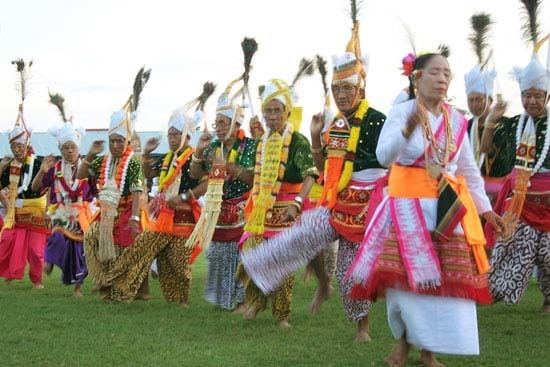
Tripura is noted for bamboo and cane handicrafts. Bamboo, wood and cane are used to create an array of furniture, utensils, hand-held fans, replicas, mats, baskets, idols and interior decoration materials. Music and dance are integral to the culture of the state. Some local musical instruments are the sarinda, chongpreng (both string instruments), and sumui (a type of flute). Each indegenous community has its own repertoire of songs and dances performed during weddings, religious occasions, and other festivities. The Tripuri and Jamatia people perform goria dance during the Goria puja. Jhum dance (also called tangbiti dance), lebang dance, mamita dance, and mosak sulmani dance are other Tripuri dance forms. Reang community, the second largest scheduled tribe of the state, is noted for its hojagiri dance that is performed by young girls balanced on earthen pitchers. Bizhu dance is performed by the Chakmas during the Bizhu festival (the last day of the month of Chaitra in Hindu calendar). Other dance forms include wangala dance of the Garo people, hai-hak dance of the Halam branch of Kuki people, and sangrai dance and owa dance of the Mog. Alongside such traditional music, mainstream Indian musical elements such as Indian classical music and dance, Rabindra Sangeet are also practised. Sachin Dev Burman, a member of the royal family, was a maestro in the filmi genre of Indian music.
Hindus believe that Tripureshwari is the patron goddess of Tripura and an aspect of Shakti. Durga puja, Kali puja, Ashokastami and the worship of the Chaturdasha deities are important festivals in the state. Some festivals represent confluence of different regional traditions, such as Ganga puja, Garia puja, Kharchi puja and Ker puja. Unakoti, Pilak and Devtamura are historic sites where large collections of stone carvings and rock sculptures are noted. Like Neermahal is a cultural Water Palace of this state. Sculptures are evidence of the presence of Buddhist and Brahmanical orders for centuries, and represent a rare artistic fusion of traditional organised religions and tribal influence.
Tripuri cuisine
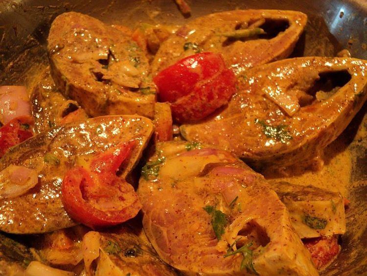
Tripuri cuisine is the type of food predominantly served in the northeast Indian state of Tripura. The Tripuris are essentially nonvegetarians and hence the main courses are mainly prepared using meat, but with the addition of vegetables. Traditional Tripuri cuisine is known as Mui Borok. Tripuri food has a key ingredient called Berma, which is dried and fermented fish. The food is considered to be healthy as it is prepared without oil. Flavor wise, Berma is more on the sour side. Tripuri food such as bangui rice and fish stews, bamboo shoots, fermented fish, local herbs, and meat roasts are extremely popular within and outside the state.
The Tripuris are in general non-vegetarian, although some followers of Vaishnavism tend toward vegetarianism.