
Established 350 Preceded by Succeeded by Capitals Pragjyotishpura, Tezpur | Disestablished 1140 Historical era Middle kingdoms of India | |
 | ||
Government Absolute monarchy, unitary state Today part of India
Bhutan
Bangladesh | ||
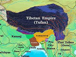
Kāmarūpa (/ˈkɑːməˌruːpə/; also called Pragjyotisha), was an ancient kingdom on the Indian subcontinent; it is one of the historical kingdoms of Assam, India, alongside Davaka, that existed from 350 to 1140 CE. Ruled by three dynasties from their capitals in present-day Guwahati, North Guwahati and Tezpur, it at its height covered the entire Brahmaputra Valley, North Bengal, Bhutan and parts of Bangladesh, and at times portions of West Bengal and Bihar.
Contents
- Kamarupa 2016 calendar
- Boundaries
- State
- Political history
- Varman dynasty c350c650
- Mlechchha dynasty c655c900 CE
- Pala dynasty c900c1100
- Non dynastic Independent Kings
- End of Kamarupa kingdom
- References
Though the historical kingdom disappeared by 12th century to be replaced by smaller political entities, the notion of Kamarupa persisted and ancient and medieval chroniclers continued to call this region by this name.
The name of this kingdom survives in Kamrup, a present-day district in Assam.
Kamarupa 2016 calendar
Boundaries
According to the 10th century Kalika Purana and the 7th century Xuanzang, the western boundary was the historical Karatoya River. The eastern border was the temple of the goddess Tamreshvari (Pūrvāte Kāmarūpasya devī Dikkaravasini, given in Kalika Purana) near present-day Sadiya, in the eastern most corner of Assam, which too agrees with Xuanzang. The people of Kamarupa were aware of Sichuan which lay two months' journey away from its eastern borders.
The southern boundary was near the border between the Dhaka and Mymensingh districts in Bangladesh. Thus it spanned the entire Brahmaputra valley and at various times included present-day Bhutan and parts of Bangladesh. This is supported by the various epigraphic records found scattered over these regions. The kingdom appears to have broken up entirely by the 13th century into smaller kingdoms and from among them rose the Kamata kingdom in the west and the Ahom kingdom in the east as the main successor kingdoms.
State
The extent of state structures can be culled from the numerous Kamarupa inscriptions left behind by the Kamarupa kings as well as accounts left by travellers such as those from Xuanzang. Governance followed the classical saptanga structure of state.
Kings and courts: The king was considered to be of divine origin. Succession was primogeniture, but two major breaks resulted in different dynasties. In the second, the high officials of the state elected a king, Brahmapala, after the previous king died without leaving an heir. The royal court consisted of a Rajaguru, poets, learned men and physicians. Different epigraphic records mention different officials of the palace: Mahavaradhipati, Mahapratihara, Mahallakapraudhika, etc.
Council of Ministers: The king was advised by a council of ministers (Mantriparisada), and Xuanzang mentions a meeting Bhaskaravarman had with his ministers. According to the Kamauli grant, these positions were filled by Brahmanas and were hereditary. State functions were specialized and there were different groups of officers looking after different departments.
Revenue: Land revenue (kara) was collected by special tax-collectors from cultivators. Cultivators who had no proprietary rights on the lands they tilled paid uparikara. Duties (sulka) were collected by toll collectors (kaivarta) from merchants who plied keeled boats. The state maintained a monopoly on copper mines (kamalakara). The state maintained its stores and treasury via officials: Bhandagaradhikrita and Koshthagarika.
Grants: The king occasionally gave Brahmanas grants (brahmadeya), which consisted generally of villages, water resources, wastelands etc. (agraharas). Such grants conferred on the donee the right to collect revenue and the right to be free of any regular tax himself and immunity from other harassments. Sometimes, the Brahmanas were relocated from North India, with a view to establish varnashramdharma. Nevertheless, the existence of donees indicate the existence of a feudal class. Grants made to temples and religious institutions were called dharmottara and devottara respectively.
Land survey: The land was surveyed and classified. Arable lands (kshetra) were held individually or by families, whereas wastelands (khila) and forests were held collectively. There were lands called bhucchidranyaya that were left unsurveyed by the state on which no tax was levied.
Administration: The entire kingdom was divided into a hierarchy of administrative divisions. From the highest to the lowest, they were bhukti, mandala, vishaya, pura (towns), agrahara (collection of villages) and grama (village). These units were administered by headed by rajanya, rajavallabha, vishayapati etc. Some other offices were nyayakaranika, vyavaharika, kayastha etc., led by the adhikara. They dispensed judicial duties too, though the ultimate authority lay with the king. Law enforcement and punishments were made by officers called dandika, (magistrate) and dandapashika (one who executed the orders of a dandika).
Political history
Kamarupa, first mentioned on Samudragupta's Allahabad rock pillar as a frontier kingdom, began as a subordinate but sovereign ally of the Gupta empire around present-day Guwahati in the 4th century. It finds mention along with Davaka, a kingdom to the east of Kamarupa in the Kapili river valley in present-day Nagaon district, but which is never mentioned again as an independent political entity in later historical records. Kamarupa, which was probably one among many such state structures, grew territorially to encompass the entire Brahmaputra valley and beyond. The kingdom was ruled by three major dynasties, all of which drew their lineage from the legendary king Naraka, who is said to have established his line by defeating the aboriginal king Ghatakasura of the Danava dynasty.
Varman dynasty (c350–c650)
Pushyavarman (350–374) established the Varman Dynasty, by fighting many enemies from within and without his kingdom; but his son Samudravarman (374–398), named after Samudragupta, was accepted as an overlord by many local rulers. Nevertheless, subsequent kings continued their attempts to stabilise and expand the kingdom. The Nagajari Khanikargaon rock inscription of 5th century found in Golaghat adduces the fact that the kingdom spread to the east very quickly. Kalyanavarman (422-446) occupied Davaka and Mahendravarman (470-494) further eastern areas. Narayanavarma (494–518) and his son Bhutivarman (518–542) offered the ashwamedha (horse sacrifice); and as the Nidhanpur inscription of Bhaskarvarman avers, these expansions included the region of Chandrapuri visaya, identified with present-day Sylhet division. Thus, the small but powerful kingdom that Pushyavarman established grew in fits and starts over many generations of kings and expanded to include adjoining possibly smaller kingdoms and parts of Bangladesh.
After the initial expansion till the beginning of Bhutivarman's reign, the kingdom came under attack from Yasodharman (525–535) of Malwa, the first major assault from the west. Though it is unclear what the effect of this invasion was on the kingdom; that Bhutivarman's grandson, Sthitavarman (566–590), enjoyed victories over the Gauda of Karnasuvarna and performed two aswamedha ceremonies suggests that the Kamarupa kingdom had recovered nearly in full. His son, Susthitavarman (590–600) came under the attack of Mahasenagupta of East Malwa. These back and forth invasions were a result of a system of alliances that pitted the Kamarupa kings (allied to the Maukharis) against the Gaur kings (allied with the East Malwa kings). Susthitavarman died as the Gaur invasion was on, and his two sons, Suprathisthitavarman and Bhaskarvarman fought against an elephant force and were captured and taken to Gaur. They were able to regain their kingdom due probably to a promise of allegiance. Suprathisthitavarman's regin is given as 595–600, a very short period, at the end of which he died without an heir.
Supratisthitavarman was succeeded by his brother, Bhaskarvarman (600–650), the most illustrious of the Varman kings who succeeded in turning his kingdom and invading the very kingdom that had taken him captive. Bhaskarvarman had become strong enough to offer his alliance with Harshavardhana just as the Thanesar king ascended the throne in 606 after the murder of his brother, the previous king, by Shashanka of Gaur. Harshavardhana finally took control over the kingless Maukhari kingdom and moved his capital to Kanauj. The alliance between Harshavardhana and Bhaskarvarman squeezed Shashanka from either side and reduced his kingdom, though it is unclear whether this alliance resulted in his complete defeat. Nevertheless, Bhaskarvarman did issue the Nidhanpur copper-plate inscription from his victory camp in the Gaur capital Karnasuvarna (present-day Murshidabad, West Bengal) to replace a grant issued earlier by Bhutivarman for a settlement in the Sylhet region of present-day Bangladesh.
Mlechchha dynasty (c655–c900 CE)
After Bhaskaravarman's death without an heir, the kingdom passed into the hands of Salasthambha (655–670), an erstwhile local governor and a member of an aboriginal group called Mlechchha (or Mech), after a period of civil and political strife. This dynasty too drew its lineage from the Naraka dynasty, though it had no dynastic relationship with the previous Varman dynasty. The capital of this dynasty was Haruppeshvara, now identified with modern Dah Parbatiya near Tezpur. The kingdom took on feudal characteristics with political power shared between the king and second and third tier rulers called mahasamanta and samanta who enjoyed considerable autonomy. The last ruler in this line was Tyāga Singha (890–900).
Pala dynasty (c900–c1100)
After the death of Tyāgasimha without an heir, a member of the Bhauma family, Brahmapala (900–920), was elected as king by the ruling chieftains, just as Gopala of the Pala dynasty of Bengal was elected. The original capital of this dynasty was Hadapeshvara, and was shifted to Durjaya built by Ratnapala, near modern Guwahati. The greatest of the Pala kings, Dharmapala had his capital at Kamarupanagara, now identified with North Guwahati. The last Pala king was Jayapala (1075–1100). Around this time, Kamarupa was attacked and the western portion was conquered by the Pala king Ramapala.
Non-dynastic Independent Kings
The Gaur king could not hold Kamarupa for long, and Timgyadeva (1110–1126) ruled Kamarupa independently for sometime. A minister of the Gaur king Kumarapala (the son of Ramapala) began an expedition against Timgyadeva and installed himself as a ruler at Hamshkonchi in the Kamrup region. Though he maintained friendly relationships with Kumarapala, he called styled himself after the Kamarupa kings issuing grants under the elephant seal of erstwhile Kamarupa kings and assuming the title of Maharajadhiraja. The period saw a waning of the Kamarupa kingdom, and in 1205 the Afghan Muhammad-i-Bakhtiyar passed through Kamarupa against Tibet which ended in a disaster. Mughith al-Din Yuzbak of the Mameluk rulers of Bengal attacked and defeated an unknown ruler of Kamarupa in 1257. But Yuzbak could not hold on to the capital as he was weakened by the Monsoon rains that led to his defeat and death by the local population.
End of Kamarupa kingdom
The Kamarupa kingdom came to an end in the middle of the 13th century when a ruler of Kamarupanagara (Guwahati), named Sandhya, moved his capital to Kamatapur (North Bengal) and established the Kamata kingdom. At that time, western Kamarupa was being ruled by the chiefs of the Bodo people, Koch and Mech tribes. In central Assam the Kachari kingdom was growing, and further east, the Sutiya kingdom. The Ahoms, who would establish a strong and independent kingdom later, began building their state structures in the region between the Kachari and the Sutiya kingdoms.