This timeline documents all of the events of the 2014 Pacific typhoon season. Most of the tropical cyclones forming between May and November. The scope of this article is limited to the Pacific Ocean, north of the equator between 100°E and the International Date Line. Tropical storms that form in the entire Western Pacific basin are assigned a name by the Japan Meteorological Agency. Tropical depressions that form in this basin are given a number with a "W" suffix by the United States' Joint Typhoon Warning Center. In addition, the Philippine Atmospheric, Geophysical and Astronomical Services Administration (PAGASA) assigns names to tropical cyclones (including tropical depressions) that enter or form in the Philippine area of responsibility. These names, however, are not in common use outside of the Philippines.
During the season, 30 systems were designated as Tropical Depressions by either, the Japan Meteorological Agency (JMA), the Philippine Atmospheric, Geophysical and Astronomical Services Administration (PAGASA), the Joint Typhoon Warning Center (JTWC), or other National Meteorological and Hydrological Services such as the China Meteorological Administration and the Hong Kong Observatory. As they run the Regional Specialized Meteorological Centre for the Western Pacific, the JMA assigns names to Tropical Depressions should they intensify into a tropical storm. PAGASA also assign local names to tropical depressions which form within their area of responsibility; however, these names are not in common use outside of PAGASA’s area of responsibility. In this season, 19 systems entered or formed in the Philippine area of responsibility, which eight of them directly made landfall over the Philippines.
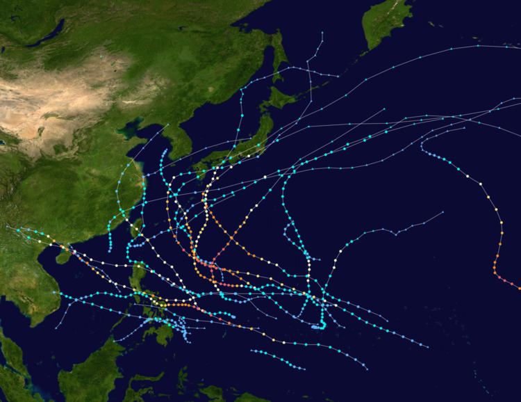
The first half of the season was relatively active with seven named storms. During the season, six typhoons underwent rapid deepening. The deadliest and damaging storm so far is Rammasun, killing nearly 200 people with damages of about $7 billion. During August, Hurricane Genevieve entered the basin as a super typhoon. During mid-August, as Genevieve began to weaken, tropical activity in the Northwest Pacific began to decrease, making it the first time no tropical storms develop during the peak of the season since records began. This also occurred for the second time during mid-October, after the dissipation of Vongfong. In early October, Vongfong reached its peak intensity as a strong Category 5 typhoon, the strongest since Typhoon Haiyan in November 2013.
The season has a relatively below-normal quantity of named storms, although a large number of those (eight) became super typhoons, including seven Category 5 storms. The season is not as active and costly as the previous season. During the first half of the season, it was active with seven storms forming due to a developing weak El Niño, however this failed during August. The most active month so far in the season is July; with four storms developing and made landfall, with three of them reaching super typhoon strength. With this, the season became quiet as of August 15, following the dissipation of Genevieve, although only few depressions formed but never strengthened into tropical storms. This continued until the first week of September, as the tropics within the basin started to get active again, with three tropical depressions in the same time. Tropical activity began to rise again during mid-September, although the season became quiet again after the dissipation of Vongfong, with a pause of Nuri's lifecycle.
January 15
00:00 UTC – The Japan Meteorological Agency (JMA) reports that a tropical depression has formed while located roughly 405 km (250 mi) east of Surigao City, Philippines.January 18
00:00 UTC – The JMA reports that the tropical depression previously located east of Surigao City has intensified into a tropical storm and names it "Lingling". Simultaneously, they report that the storm has attained its peak intensity, with maximum 10-minute sustained winds of 65 km/h (40 mph).00:00 UTC – The Joint Typhoon Warning Center (JTWC) designates Tropical Storm Lingling as Tropical Depression 01W. Simultaneously, they report that the storm has attained its peak intensity, with maximum 1-minute sustained winds of 55 km/h (35 mph).January 19
18:00 UTC – The JTWC reports that Tropical Depression Lingling (01W) has weakened into an area of low pressure while located roughly 385 km (240 mi) southeast of Davao City, Philippines.January 20
00:00 UTC – The JMA reports that Tropical Storm Lingling (01W) has weakened into a tropical depression.00:00 UTC – The JTWC reports that the remnants of Lingling (01W) have dissipated while located roughly 430 km (265 mi) southeast of Davao City.12:00 UTC – The JMA reports that Tropical Depression Lingling (01W) has dissipated while located roughly 405 km (250 mi) southeast of Davao City.January 29
00:00 UTC – The JMA reports that a tropical depression has formed while located roughly 475 km (295 mi) southwest of Guam.January 30
18:00 UTC – The JTWC designates the tropical depression previously located southwest of Guam as Tropical Depression 02W.January 31
00:00 UTC – The JMA reports that Tropical Depression 02W has intensified into a tropical storm and names it "Kajiki". Simultaneously, they report that the storm has attained its peak intensity, with maximum 10-minute sustained winds of 65 km/h (40 mph).06:00 UTC – The JTWC reports that Tropical Depression Kajiki (02W) has intensified into a tropical storm. Simultaneously, they report that the storm has attained its peak intensity, with maximum 1-minute sustained winds of 55 km/h (35 mph).12:00 – 18:00 UTC – Tropical Storm Kajiki (02W) makes landfall near Abuyog, Philippines with 10-minute sustained winds of 65 km/h (40 mph).18:00 UTC – The JTWC reports that Tropical Storm Kajiki (02W) has weakened into a tropical depression.18:00 – 00:00 UTC (1 February) – Tropical Storm Kajiki (02W) makes landfalls twice, near Tabogon, Philippines and Barotac Viejo, Philippines with 10-minute sustained winds of 65 km/h (40 mph).February 1
00:00 UTC – The JTWC reports that Tropical Depression Kajiki (02W) has weakened into an area of low pressure while located roughly 65 km (40 mi) northwest of Roxas City, Philippines.06:00 UTC – The JMA reports that Tropical Storm Kajiki (02W) has weakened into a tropical depression.06:00 UTC – The JTWC reports that the remnants of Kajiki (02W) have dissipated while located roughly 230 km (145 mi) northwest of Roxas City.06:00 – 12:00 UTC – Tropical Depression Kajiki (02W) makes landfall near El Nido, Philippines with 10-minute sustained winds of 55 km/h (35 mph).18:00 UTC – The JMA reports that Tropical Depression Kajiki (02W) has dissipated while located roughly 145 km (90 mi) northwest of Puerto Princesa, Philippines.February 27
12:00 UTC – The JMA reports that a tropical depression has formed about 620 km (385 mi) southeast of Guam.February 28
00:00 UTC – The JTWC designates the tropical depression previously located southeast of Guam as Tropical Depression 03W.12:00 UTC – The JMA reports that Tropical Depression 03W has intensified into a tropical storm, and names it "Faxai".18:00 UTC – The JTWC reports that Tropical Depression Faxai (03W) has intensified into a tropical storm.March 3
06:00 UTC – The JMA reports that Tropical Storm Faxai (03W) has intensified into a severe tropical storm.March 4
12:00 UTC – The JMA reports that Severe Tropical Storm Faxai (03W) has intensified into a typhoon. Simultaneously, they report that the storm has attained its peak intensity, with maximum 10-minute sustained winds of 120 km/h (75 mph).12:00 UTC – The JTWC reports that Tropical Storm Faxai (03W) has intensified into a category 1 typhoon.18:00 UTC – The JTWC reports that Typhoon Faxai (03W) has attained its peak intensity, with maximum 1-minute sustained winds of 145 km/h (90 mph).March 5
00:00 UTC – The JMA reports that Typhoon Faxai (03W) has weakened into a severe tropical storm.06:00 UTC – The JTWC reports that Typhoon Faxai (03W) has weakened into a tropical storm.12:00 UTC – The JMA reports that Severe Tropical Storm Faxai (03W) has weakened into a tropical storm.12:00 UTC – The JTWC reports that Tropical Storm Faxai (03W) has transitioned into an extratropical cyclone while located roughly 1,345 km (835 mi) northwest of Wake Island.18:00 UTC – The JMA reports that Tropical Storm Faxai (03W) has transitioned into an extratropical cyclone while located roughly 1,255 km (780 mi) northwest of Wake Island.March 6
12:00 UTC – The JTWC reports that the extratropical remnants of Faxai have dissipated while located 900 km (560 mi) northwest of Wake Island.March 8
18:00 UTC – The JMA reports that the extratropical remnants of Faxai have dissipated while located roughly 785 km (490 mi) northeast of Wake Island.March 1806:00 UTC — The JMA reports that a tropical depression has developed about 170 km (105 mi) to the south of Yap Island.March 2018:00 UTC — PAGASA initiates warnings on the tropical depression and names it Caloy.March 2120:00 UTC — Tropical Depression Caloy makes landfall on the Philippine island of Mindanao, in the vicinity of Tandag Surigao Del Sur.March 2200:00 UTC — The JTWC initiates warnings on the tropical depression and assigns it the designation 04W.18:00 UTC — The JTWC issues its final advisory on Tropical Depression Caloy.April 218:00 UTC — The JMA reports that a tropical depression has formed about 1,260 km (785 mi) to the north-northeast of Port Moresby, Papua New Guinea.April 300:00 UTC — The JTWC initiates advisories on the tropical depression and assigns it the designation 05W.April 418:00 UTC — The JTWC reports that Tropical Depression 05W has intensified into a tropical storm.April 500:00 UTC — The JMA reports that Tropical Depression 05W has intensified into a tropical storm and names it Peipah. They also estimate that the system has peaked with 10-minute sustained wind speeds of 65 km/h (45 mph).12:00 UTC — The JMA reports that Tropical Storm Peipah has weakened into a tropical depression.April 606:00 UTC — PAGASA reports that Tropical Depression Peipah has entered its area of responsibility and names it Domeng.12:00 UTC — The JTWC reports that Tropical Storm Peipah (Domeng) has weakened into a tropical depression.April 806:00 UTC — The JMA reports that Tropical Depression Peipah (Domeng) has dissipated to the southeast of Manilla on the Philippine island of Luzon.April 1006:00 UTC — The JTWC issues its final advisory on Tropical Depression Peipah (Domeng), as the system has weakened into a tropical disturbance.April 1312:00 UTC — The JMA reports that a tropical depression has developed, while located about 1,000 km (620 mi) to the southeast of Manilla.April 1506:00 UTC — The tropical depression is last noted by the JMA, while located about 745 km (465 mi) to the southeast of Manilla.April 1912:00 UTC — The JMA reports that a tropical depression has developed about 480 km (300 mi) to the southwest of Hagåtña, Guam.April 2100:00 UTC — The tropical depression is last noted by the JMA, while it is located about 1,130 km (700 mi) to the southwest of Hagåtña, Guam.April 2700:00 UTC — The JMA reports that a tropical depression has developed about 415 km (260 mi) to the southeast of Hagåtña, Guam.12:00 UTC — The JTWC initiates advisories on the tropical depression and assigns it the designation 06W.April 2800:00 UTC — Both the JTWC and the JMA report that the tropical depression has intensified into a tropical storm, with the JMA naming the system Tapah.April 2900:00 UTC — The JMA reports that Tropical Storm Tapah has peaked with 10-minute sustained wind speeds of 95 km/h (60 mph) which makes it a severe tropical storm.00:00 UTC — The JTWC reports that Tropical Storm Tapah has intensified into a typhoon.06:00 UTC — The JTWC reports that Typhoon Tapah has peaked with 1-minute sustained wind speeds of 130 km/h (80 mph) while equivalent to a Category 1 typhoon on the SSHWS.18:00 UTC — The JTWC reports that Typhoon Tapah has weakened into a tropical storm.April 3006:00 UTC — The JMA reports that Severe Tropical Storm Tapah has weakened into a tropical storm.May 100:00 UTC — The JMA reports that Tropical Storm Tapah has weakened into a tropical depression.09:00 UTC — The JTWC reports that Tropical Storm Tapah has weakened into a tropical depression and issues its final advisory on the system.May 212:00 UTC — The JMA reports that Tropical Depression Tapah has dissipated, about 1,300 km (810 mi) to the southeast of Tokyo, Japan.June 900:00 UTC — The JMA reports that a tropical depression has developed about 475 km (295 mi) to the south-southwest of Taipei, Taiwan.June 1003:00 UTC — PAGASA initiates advisories on the tropical depression, previously located to the south-southwest of Taipei, Taiwan and names it Ester.June 1100:00 UTC — The JMA reports that Tropical Depression Ester has intensified into a tropical storm.06:00 UTC — The JMA names Tropical Storm Ester: Mitag as they estimate that the system has peaked with 10-minute sustained wind speeds of 75 km/h (45 mph).June 1200:00 UTC — The JMA reports that Tropical Storm Mitag (Ester) has weakened into a tropical depression.00:00 UTC — The JMA reports that a tropical depression has developed about 890 kilometres (555 mi) to the south-southwest of Taipei, Taiwan.06:00 UTC — The JMA reports that Tropical Depression Mitag (Ester) has dissipated.June 1400:00 UTC — The JMA reports that the tropical depression previously located to the south-southwest of Taipei, Taiwan has developed into a tropical storm.06:00 UTC — The JMA names the tropical storm: Hagibis.06:00 UTC — The JTWC initiates advisories on Tropical Storm Hagibis and assigns it the designation 07W.June 1508:50 UTC — Tropical Storm Hagibis made landfall at Shantou in the Chinese province of Guangdong.12:00 UTC — The JTWC issues its final advisory on Tropical Storm Hagibis, after the system had made landfall on China.18:00 UTC — The JMA reports that Tropical Storm Hagibis has weakened into a tropical depression over Guangdong.June 1618:00 UTC — The JTWC re-initiates advisories on Tropical Depression Hagibis, after the system has moved into the East China Sea.June 1700:00 UTC — The JMA reports that Tropical Depression Hagibis has re-intensified into a tropical storm and estimates that it has reached its peak intensity with 10-minute sustained wind speeds of 75 km/h (45 mph).12:00 UTC — The JMA reports that Tropical Storm Hagibis has weakened into a tropical depression, as the system passes near or over the Japanese region of Kyūshū.18:00 UTC — The JMA reports that Tropical Depression Hagibis, has transitioned into an extratropical cyclone.June 2300:00 UTC — The JMA stops monitoring the extratropical remnants of Tropical Storm Hagibis, as they move into the Eastern Pacific.July 212:00 UTC — The JMA reports that a tropical depression has developed about 600 km (375 mi) to the southeast of Haganta, Guam.July 300:00 UTC — The JTWC initiates advisories on the tropical depression and assigns it the designation 08W.18:00 UTC — The JMA and JTWC report that Tropical Depression 08W has intensified into a tropical storm.July 400:00 UTC — The JMA names the tropical storm: Neoguri.12:00 UTC — The JMA reports that Tropical Storm Neoguri, has intensified into a typhoon.18:00 UTC — The JTWC reports that Tropical Storm Neoguri has intensified and become equivalent to a Category 1 typhoon on the SSHWS.July 500:00 UTC — The JTWC reports that Typhoon Neoguri has become equivalent to a Category 2 typhoon on the SSHWS.06:00 UTC — The JTWC reports that Typhoon Neoguri has become equivalent to a Category 4 typhoon on the SSHWS.15:00 UTC — PAGASA reports that Typhoon Neoguri, is about to enter the Philippine area of responsibility and names it Florita.July 618:00 UTC — The JMA reports that Typhoon Neoguri (Florita) has reached its peak intensity, with 10-minute sustained wind speeds of 185 km/h (115 mph).18:00 UTC — The JTWC reports that Typhoon Neoguri (Florita) has become a super typhoon.July 700:00 UTC — The JTWC reports that Super Typhoon Neoguri (Florita) has reached its peak intensity with 1-minute sustained wind speeds of 250 km/h (155 mph).18:00 UTC — The JTWC reports that Super Typhoon Neoguri (Florita) has weakened into a typhoon and become equivalent to a Category 3 typhoon on the SSHWS.July 818:00 UTC — The JTWC reports that Typhoon Neoguri (Florita) has weakened and become equivalent to a Category 2 typhoon on the SSHWS.July 906:00 UTC — The JMA reports that a tropical depression has developed about 1,200 km (745 mi) to the southeast of Hagåtña, Guam.06:00 UTC — The JMA reports that Typhoon Neoguri (Florita) has weakened into a severe tropical storm.12:00 UTC — The JTWC reports that Typhoon Neoguri (Florita) has weakened into a tropical storm.July 1000:00 UTC — The JMA reports that Typhoon Neoguri (Florita) has made landfall over the island of Kyushu.12:00 UTC — The JTWC issues its final advisory on Tropical Storm Neoguri (Florita) as it transitions into an extratropical cyclone and issues its final advisory.12:00 UTC — The JTWC initiates advisories on the tropical depression that was previously located to the southeast of Hagåtña, Guam and assigns it the designation 09W.18:00 UTC — The JMA reports that Severe Tropical Storm Neoguri (Florita) has weakened into a tropical storm.July 1100:00 UTC — The JMA reports that Tropical Storm Neoguri (Florita) has transitioned into an extratropical cyclone.00:00 UTC — The JTWC reports that Tropical Depression 09W has intensified into a tropical storm.06:00 UTC — The JMA reports that Tropical Depression 09W has intensified into a tropical storm and names it Rammasun.12:00 UTC — The JTWC reports that Tropical Storm Rammasun has weakened into a tropical depression.July 1300:00 UTC — The JTWC reports that Tropical Depression Rammasun has re-intensified into a tropical storm.00:00 UTC — PAGASA names Tropical Storm Rammasun: Glenda, as it enters the Philippine area of responsibility.12:00 UTC — The JMA reports that the extratropical remnants of former Typhoon Neoguri (Florita), have dissipated within the Sea of Okhotsk.July 1400:00 UTC — The JMA reports that Tropical Storm Rammasun has intensified into a severe tropical storm.12:00 UTC — The JTWC reports that Tropical Storm Rammasun has intensified and become equivalent to a Category 1 typhoon on the SSHWS.18:00 UTC — The JMA reports that Severe Tropical Storm Rammasun has intensified into a typhoon.July 1506:00 UTC — The JTWC reports that Tropical Storm Rammasun has intensified and become equivalent to a Category 3 typhoon on the SSHWS.July 1606:00 UTC — The JMA reports that a tropical depression, has developed to the northeast of Palau.12:00 UTC — The JMA reports that Typhoon Rammasun has weakened into a severe tropical storm.July 1700:00 UTC — The JMA reports that Severe Tropical Storm Rammasun has re-intensified into a typhoon.06:00 UTC — Typhoon Rammasun intensifies back into a Category 4 typhoon.12:00 UTC — The JMA reports that the tropical depression previously located to the northeast of Palau has become a tropical storm.12:00 UTC — The JTWC initiates advisories on the tropical depression and assigns it the designation: 10W.18:00 UTC — The JMA names the tropical storm: Matmo.18:00 UTC — The JTWC reports that Tropical Depression Matmo has intensified into a tropical storm.21:00 UTC — PAGASA reports that Tropical Storm Matmo has entered the Philippine area of responsibility and names it Henry.July 1806:00 UTC — Rammasun still slowly intensifies as the JTWC classifies it as a super typhoon.06:00 UTC — The JMA reports that Typhoon Rammasun has peaked with 10-minute sustained wind speeds of 165 km/h (105 mph).07:30 UTC — Typhoon Rammasun makes landfall at Wenchang on the island of Hainan, before emerging into the Qiongzhou Strait.11:30 UTC — Typhoon Rammasun makes landfall at Xuwen County in the Chinese province of Guangdong, before emerging into the Gulf of Tonkin.18:00 UTC — The JMA reports that Tropical Storm Matmo has intensified into a severe tropical storm.23:10 UTC — Typhoon Rammasun makes landfall at Fangchenggang in the Chinese province of Guangxi.July 1900:00 UTC — The JMA reports that Typhoon Rammasun has weakened into a severe tropical storm over the Chinese Province of Guangxi.00:00 UTC — The JTWC issues its final advisory on Typhoon Rammasun as it weakens and becomes equivalent to a Category 3 typhoon on the SSHWS over the Chinese Province of Guangxi.06:00 UTC — The JMA reports that Severe Tropical Storm Rammasun has weakened into a tropical storm over the Chinese Province of Guangxi.12:00 UTC — The JTWC reports that Tropical Storm Matmo has become equivalent to a Category 1 typhoon on the SSHWS.12:00 UTC — The JMA starts monitoring another tropical depression located east of Guam.18:00 UTC — The JTWC made its final warning on Rammasun.July 2006:00 UTC — The JMA reports that Tropical Depression Rammasun has dissipated over the Chinese Province of Yunnan.18:00 UTC — The JMA reports that Severe Tropical Storm Matmo has intensified into a typhoon.July 2203:00 UTC — The tropical depression becomes better organized, as the JTWC issues a tropical cyclone formation alert on the depression.15:00 UTC — The JTWC upgrades Matmo to a Category 2 typhoon on the SSHWS.16:15 UTC — Typhoon Matmo makes landfall on Taidong, Taiwan, before emerging into the Taiwan Strait.18:00 UTC — The JMA reports that Typhoon Matmo has weakened into a severe tropical storm.21:00 UTC — The tropical depression weakens to a LPA.July 2306:00 UTC — Matmo slightly weakens to a Category 1 typhoon on the SSHWS.Matmo makes landfall over eastern China.12:00 UTC — The JMA reports that Severe Tropical Storm Matmo has weakened into a tropical storm, while located over the Chinese province of Fujian.15:00 UTC — The JTWC issues its final advisory on Matmo, as it rapidly weakens to a moderate tropical storm and declares it extratropical.July 2506:00 UTC — The JMA reports that Tropical Storm Matmo has transitioned into an extratropical cyclone, while located over the Yellow Sea.09:10 UTC — The extratropical remnants of Typhoon Matmo make landfall at Rongcheng in the Chinese province of Shandong.July 2606:00 UTC — The JMA reports that the extratropical remnants, of Typhoon Matmo have dissipated over North Korea.July 2718:00 UTC — The JMA reports that a tropical depression has developed about 800 km (500 mi) to the southeast of Hagåtña, Guam.July 2806:00 UTC — The JMA reports that a tropical depression has developed about 1,400 km (870 mi) to the northeast of Manila, Philippines.09:00 UTC — The other tropical depression east of the Philippines starts to move in a northward direction and intensify.15:00 UTC — The JTWC designates the depression near the Caroline Islands as 11W.July 2900:00 UTC — PAGASA initiates advisories on the tropical depression and names it Inday.00:00 UTC — The JMA reports that Tropical Depression Inday has intensified into a tropical storm.06:00 UTC — The JMA names Tropical Depression Jose: Halong.12:00 UTC — The JMA reports that Tropical Depression Inday has intensified into a tropical storm.21:00 UTC — The JMA names Tropical Storm Inday: Nakri.July 3118:00 UTC — The JMA reports that tropical storms Halong and Nakri (Inday) have intensified into severe tropical storms.August 118:00 UTC — The JMA reports that Severe Tropical Storm Halong has intensified into a typhoon.August 206:00 UTC — Halong intensifies into a Category 4 typhoon, just before entering the PAR.06:00 UTC — The JTWC initiates advisories on Tropical Storm Nakri (Inday) and assigns it the designation 12W.12:00 UTC — The JMA reports that Severe Tropical Storm Nakri (Inday) has weakened into a tropical storm.18:00 UTC — Due to the explosive intensification of Halong, JTWC upgrades it to a Category 5 super typhoon.August 306:00 UTC — The JTWC reports that Tropical Storm Nakri has weakened into a tropical depression.21:00 UTC — The JTWC issues its final advisory on Tropical Depression Nakri (Inday), as the system approached South Korea's west coast.August 400:00 UTC — Halong starts to undergo an eyewall replacement cycle, as it weakens to a mid-Category 4 typhoon.06:00 UTC — The JMA reports that Tropical Depression Nakri has dissipated over South Korea.August 603:00 UTC — Halong weakens to a minimal typhoon, due to the continuation of the eyewall replacement cycle.August 706:00 UTC — The JMA reports that Hurricane Genevieve, has become a typhoon as it moves into the basin from the Central Pacific.06:00 UTC — The JTWC reports that Typhoon Genevieve has entered the basin, while equivalent to a Category 4 super typhoon on the SSHWS.12:00 UTC — The JTWC reports that Typhoon Genevieve has become equivalent, to a Category 5 super typhoon on the SSHWS.18:00 UTC — The JMA reports that Typhoon Genevieve has reached its peak intensity, with 10-minute sustained windspeeds of 205 km/h (125 mph).August 812:00 UTC — The JTWC reports that Genevieve has weakened and become equivalent to a Category 4 super typhoon on the SSHWS.18:00 UTC — The JTWC reports that Genevieve has weakened and become equivalent to a Category 4 typhoon on the SSHWS.August 1006:00 UTC — The JMA reports that Typhoon Halong has weakened into a severe tropical storm.18:00 UTC — The JMA reports that Typhoon Genevieve has weakened into a severe tropical storm.August 1100:00 UTC — The JMA reports that Severe Tropical Storm Halong has transitioned into an extratropical cyclone.00:00 UTC — The JTWC issues their final warning on Halong, as it degenerates into an extratropical cyclone.06:00 UTC — The JMA reports that Severe Tropical Storm Genevieve has weakened into a tropical storm.August 1206:00 UTC — The JMA reports that Tropical Storm Genevieve has weakened into a tropical depression.August 1412:00 UTC — The JMA reports that Tropical Depression Genevieve has dissipated.August 1506:00 UTC — The JMA reports that the extratropical remnants of Typhoon Halong have dissipated.August 1900:00 UTC — The JMA briefly monitors a tropical depression, that was located to the northeast of Hong Kong, China.August 2706:00 UTC — The JMA monitors another tropical depression in the South China Sea.18:00 UTC — The system shows a bit of intensification, as it nearly makes landfall over Hainan Island.August 2903:00 UTC — Although, the depression is located over land and with this, it transitioned into an overland low-pressure.18:00 UTC — A low-pressure area forms from an area of convection southeast of Palau.August 3100:00 UTC — It intensifies into a tropical disturbance and enters an area of favorable conditions of strengthening into a tropical storm in the next couple of days.September 406:00 UTC — The JMA reports that a tropical depression has developed about 1,885 km (1,170 mi) to the southeast of Tokyo, Japan.September 512:00 UTC — The JMA reports that a tropical depression has developed about 800 km (495 mi) to the southeast of Taipei, Taiwan.18:00 UTC — The JMA stops monitoring the tropical depression previously located to the southeast of Tokyo, Japan.18:00 UTC — The JMA reports that a tropical depression has developed within the South China Sea about 400 km (250 mi) to the west of Manilla, Philippines.September 609:00 UTC — PAGASA names the tropical depression Karding.18:00 UTC — The JMA reports that the tropical depression previously located to the southeast of Taipei, Taiwan, has intensified into a tropical storm.September 700:00 UTC — The JMA names the tropical storm Fengshen.00:00 UTC — The JTWC starts monitoring Fengshen as a tropical depression and assigns it the designation 13W.06:00 UTC — The JTWC reports that Tropical Depression Fengshen has intensified into a tropical storm.06:00 UTC — The JTWC initiates advisories on Tropical Depression Karding and assigns it the designation 14W.18:00 UTC — The JMA reports that Tropical Storm Fengshen has intensified into a severe tropical storm.September 800:00 UTC — The JTWC made their final warning on Tropical Depression 14W (Karding), as it makes landfall over Southern China.06:00 UTC — The JMA estimates that Severe Tropical Storm Fengshen has reached its peak intensity, with 10-minute sustained wind speeds of 110 km/h (70 mph).12:00 UTC — The JMA stops monitoring Tropical Depression Karding.September 1018:00 UTC — The JTWC reports that Tropical Depression 15W has developed about 335 km (210 mi) to the east of Yap.18:00 UTC — The JMA reports that Severe Tropical Storm Fengshen has transitioned into an extratropical cyclone.September 1106:00 UTC — The JMA reports that the extra tropical remnants of Severe Tropical Storm Fengshen have dissipated to the east of Japan.18:00 UTC — The JMA starts monitoring Tropical Depression 15W as a tropical depression.September 1206:00 UTC — The JMA reports that Tropical Depression 15W has intensified into a tropical storm and names it Kalmaegi.09:00 UTC — PAGASA names Tropical Storm Kalmaegi: Luis, as the system enters its area of responsibility.September 1300:00 UTC — The JMA reports that Tropical Storm Kalmaegi has intensified into a severe tropical storm.15:00 UTC — The JTWC upgrades Kalmaegi to a Category 1 typhoon.18:00 UTC — The JMA reports that Severe Tropical Storm Kalmaegi has intensified into a typhoon.September 1412:00 UTC — Typhoon Kalmaegi makes landfall over Cagayan.12:00 UTC — Due to land interaction, the JTWC downgrades the system to a tropical storm.September 1600:00 UTC — The JMA estimates that Typhoon Kalmaegi has reached its peak intensity of 75 knots.01:40 UTC — Typhoon Kalmaegi makes landfall at Wenchang on the island of Hainan, before emerging into the Qiongzhou Strait.04:45 UTC — Typhoon Kalmaegi makes landfall at Xuwen County in the Chinese province of Guangdong, before emerging into the Gulf of Tonkin.15:00 UTC — Typhoon Kalmaegi makes landfall over the Vietnamese province of Quảng Ninh.18:00 UTC — The JMA reports that Typhoon Kalmaegi has weakened into a severe tropical storm, while the system is located over the Vietnamese province of Lạng Sơn.18:00 UTC — The JTWC reports that Typhoon Kalmaegi has weakened into a tropical storm and issues its final advisory on the system.September 1700:00 UTC — The JMA reports that a tropical depression has developed to the south-east of Manilla, Philippines.06:00 UTC — The JMA reports that Severe Tropical Storm Kalmaegi has weakened into a tropical storm, while the system is located over the Chinese province of Yunnan.09:00 UTC — PAGASA names the tropical depression: Mario.12:00 UTC — The JTWC begins issuing warnings on the system and designates it as Tropical Depression 16W.12:00 UTC — The JMA reports that the tropical depression has intensified into Tropical Storm Fung-wong.12:00 UTC — The JMA reports that Tropical Storm Kalmaegi has weakened into a tropical depression over the Laotian province of Phongsaly.September 1800:00 UTC — The JMA reports that Tropical Depression Kalmaegi, has dissipated over the Burmese state of Shan.18:00 UTC — The JMA estimates that Tropical Storm Fung-wong has reached its peak intensity, with 10-minute sustained windspeeds of 85 km/h (50 mph).September 2212:00 UTC — The JMA reports that a tropical depression has developed, about 800 km (495 mi) to the northeast of Hagåtña, Guam.September 2400:00 UTC — The JMA reports that Tropical Storm Fung-wong has transitioned into an extratropical cyclone.12:00 UTC — The JTWC initiates advisories on the tropical depression and assigns it the designation 17W.12:00 UTC — The JMA reports that Tropical Depression 17W has intensified into a tropical storm and names it Kammuri.September 2506:00 UTC — The JMA reports that the extratropical remnants of Tropical Storm Fung-wong have dissipated over Japan.12:00 UTC — The JTWC reports that Tropical Depression Kammuri has intensified into a tropical storm.September 2612:00 UTC — The JMA reports that Tropical Storm Kammuri has intensified into a severe tropical storm, as the system reached its peak intensity with 10-minute sustained wind speeds of 95 km/h (60 mph).September 2712:00 UTC — The JMA reports that Severe Tropical Storm Kammuri has weakened into a tropical storm.September 2806:00 UTC — The JMA reports that a tropical depression has developed about 480 km (300 mi) to the northeast of Palikir on the Micronesian island of Pohnpei.12:00 UTC — The area of convection intensifies into Tropical Depression 18W.September 2906:00 UTC — The JMA reports that Tropical Depression 18W has intensified into tropical storm and names it Phanfone.12:00 UTC — The JTWC made their last advisory on Kammuri.September 3000:00 UTC — The JMA reports that Tropical Storm Kammuri, has transitioned into an extratropical cyclone.12:00 UTC — The JMA reports that Tropical Storm Phanfone has intensified into a severe tropical storm.October 103:00 UTC — The JTWC upgrades Phanfone to a typhoon.06:00 UTC — The JMA reports that Severe Tropical Storm Phanfone has intensified into a typhoon.18:00 UTC — The JMA stops monitoring the extratropical remnants of Severe Tropical Storm Kammuri, as they have moved across the International Dateline into the Eastern Pacific Ocean.October 203:00 UTC — Phanfone intensifies into a Category 3 typhoon.06:00 UTC — The JMA reports that Typhoon Phanfone has reached its peak intensity, with 10-minute sustained windspeeds of 175 km/h (110 mph).12:00 UTC — The JMA reports that a tropical depression has developed about 400 km (250 mi) to the east of Pohnpei.09:00 UTC — The JTWC upgrades Phanfone to Category 4 typhoon.15:00 UTC — Phanfone weakens into a Category 3 typhoon.21:00 UTC — The JTWC designates the tropical depression as Tropical Depression 19W.October 300:00 UTC — PAGASA starts issuing warnings on Phanfone and named it Neneng.12:00 UTC — The JMA names Tropical Depression 19W; Vongfong.18:00 UTC — The JMA reports that Tropical Depression Vongfong has intensified into a tropical storm.21:00 UTC — The JTWC upgrades Phanfone to a Category 4 typhoon again.October 403:00 UTC — Phanfone intensifies into a Category 4 super typhoon.09:00 UTC — Vongfong was upgraded to a Category 1 typhoon by the JTWC.12:00 UTC — The JMA reports that Tropical Storm Vongfong has intensified into a severe tropical storm.15:00 UTC — Phanfone was downgraded to a Category 3 typhoon by the JTWC.October 509:00 UTC — Phanfone weakens to a Category 2 typhoon.In the same time, the JTWC upgrades Vongfong to a Category 2 typhoon.October 606:00 UTC — The JMA reports that Typhoon Phanfone has weakened into a severe tropical storm.09:00 UTC — The JTWC issues their final advisory on Phanfone, as it transitions into an extratropical cyclone.12:00 UTC — The JMA reports that Typhoon Phanfone has transitioned into an extratropical cyclone.October 703:00 UTC — The JTWC reports that Typhoon Vongfong has intensified and become equivalent to a Category 3 typhoon on the SSHWS.06:00 UTC — PAGASA names Vongfong: Ompong, as it enters their area of responsibility.06:00 UTC — The JTWC reports that Typhoon Vongfong has intensified and become equivalent to a Category 4 typhoon on the SSHWS.12:00 UTC — The JTWC reports that Typhoon Vongfong has intensified and become equivalent to a Category 4 super typhoon on the SSHWS.18:00 UTC — The JMA reports that Typhoon Vongfong has reached its peak intensity with 10-minute sustained wind speeds of 215 km/h (130 mph).18:00 UTC — The JTWC reports that Typhoon Vongfong has intensified and become equivalent to a Category 5 super typhoon on the SSHWS.October 800:00 UTC — The JMA stops monitoring the extratropical remnants of Typhoon Phanfone, as they have moved across the International Dateline into the Eastern Pacific Ocean.October 906:00 UTC — The JTWC reports that Typhoon Vongfong has weakened and become equivalent to a Category 4 super typhoon on the SSHWS.
October 1006:00 UTC — The JTWC reports that Typhoon Vongfong has weakened and become equivalent to a Category 4 typhoon on the SSHWS.
18:00 UTC — The JTWC reports that Typhoon Vongfong has weakened and become equivalent to a Category 3 typhoon on the SSHWS.October 1106:00 UTC — The JTWC reports that Typhoon Vongfong has weakened and become equivalent to a Category 2 typhoon on the SSHWS.12:00 UTC — The JTWC reports that Typhoon Vongfong has weakened and become equivalent to a Category 1 typhoon on the SSHWS.October 1203:00 UTC — The JTWC reports that Typhoon Vongfong has weakened into a tropical storm.October 1300:00 UTC — The JMA reports that Typhoon Vongfong has weakened into a severe tropical storm, while located over the Japanese island of Kyushu.06:00 UTC — The JMA reports that Severe Tropical Storm Vongfong has made landfall on the Japanese island of Shikoku.12:00 UTC — The JMA reports that Severe Tropical Storm Vongfong has made landfall on the Japanese island of Honshu.October 1400:00 UTC — The JMA reports that Severe Tropical Storm Vongfong has transitioned into an extratropical cyclone as it emerges into the Pacific Ocean.October 1612:00 UTC — The JMA stops monitoring the extratropical remnants of Typhoon Vongfong, as they have moved across the International Dateline into the Eastern Pacific Ocean.October 3000:00 UTC — The JMA reports that a tropical depression has developed about 2,160 km (1,340 mi) to the southeast of Manilla, Philippines.October 3100:00 UTC — The JTWC initiates advisories on the tropical depression and assigns it the designation 20W.00:00 UTC — The JMA reports that Tropical Depression 20W has intensified into a tropical storm.06:00 UTC — The JMA names Tropical Depression 20W: Nuri.12:00 UTC — The JTWC reports that Tropical Depression Nuri has intensified into a tropical storm.12:00 UTC — PAGASA names Tropical Storm Nuri: Paeng, as the system enters the Philippine area of responsibility.November 100:00 UTC — The JMA reports that Tropical Storm Nuri has intensified into a severe tropical storm.12:00 UTC — The JMA reports that Severe Tropical Storm Nuri has intensified into a typhoon.18:00 UTC — The JTWC reports that Tropical Storm Nuri has intensified and become equivalent to a Category 1 typhoon on the SSHWS.November 200:00 UTC — The JTWC reports that Typhoon Nuri has intensified and become equivalent to a Category 2 typhoon on the SSHWS.06:00 UTC — The JTWC reports that Typhoon Nuri has intensified and become equivalent to a Category 4 typhoon on the SSHWS.12:00 UTC — The JMA reports that Typhoon Nuri has reached its peak intensity with 10-minute sustained wind speeds of 285 km/h (180 mph).12:00 UTC — The JTWC reports that Typhoon Nuri has intensified and become a super typhoon.18:00 UTC — The JTWC reports that Super Typhoon Nuri has intensified and become equivalent to a Category 5 typhoon on the SSHWS. At the same time they report that the system has reached its peak intensity with 1-minute sustained wind speeds of 285 km/h (180 mph).November 400:00 UTC — The JTWC reports that Super Typhoon Nuri has weakened and become equivalent to a Category 4 typhoon on the SSHWS.06:00 UTC — The JTWC reports that Super Typhoon Nuri has weakened into a typhoon.18:00 UTC — The JTWC reports that Typhoon Nuri has weakened and become equivalent to a Category 3 typhoon on the SSHWS.November 506:00 UTC — The JTWC reports that Typhoon Nuri has weakened and become equivalent to a Category 2 typhoon on the SSHWS.12:00 UTC — The JTWC reports that Typhoon Nuri has weakened and become equivalent to a Category 1 typhoon on the SSHWS.18:00 UTC — The JMA reports that Typhoon Nuri has weakened into a severe tropical storm.November 600:00 UTC — The JTWC issues its final advisory on Typhoon Nuri as it has weakened into a tropical storm and transitioned into an extratropical cyclone.18:00 UTC — The JMA reports that Severe Tropical Storm Nuri has transitioned into an extratropical cyclone.November 712:00 UTC — The JMA reports that the extratropical remnants of Typhoon Nuri have dissipated.November 2523:00 UTC — PAGASA reports that a tropical depression has developed about 260 km (160 mi) to the east of Hinatuan, Surigao del Sur on the Philippine Island of Mindanao and names it Queenie.November 2600:00 UTC — The JMA starts to monitor Tropical Depression Queenie.06:00 UTC — The JTWC initiates advisories on Tropical Depression Queenie and assigns it the designation 21W.10:00 UTC — Tropical Depression 21W (Queenie) makes landfall on the Philippine island of Mindanao, in the vicinity of Tandag, Surigao del Sur.November 2800:00 UTC — The JMA reports that Tropical Depression Queenie has intensified into a tropical storm and names it Sinlaku as it moves through the Spratly Islands.03:00 UTC — The JTWC upgrades Sinlaku to a tropical storm.12:00 UTC — PAGASA releases its final advisory on Sinlaku (Queenie) as it exits their area of responsibility.November 3003:00 UTC — The JTWC stops issuing advisories on Sinlaku.06:00 UTC — The JMA reports that Tropical Storm Sinlaku (Queenie) has weakened into a tropical depression.12:00 UTC — The JMA reports that Tropical Depression Sinlaku (Queenie) has dissipated over Vietnam.12:00 UTC — The JMA reports that a Tropical Depression has developed about 500 km (310 mi) to the southwest of Palikir on the Micronesian island of Pohnpei.December 100:00 UTC — The JMA reports that the tropical depression has developed into a tropical storm, while the JTWC classifies the system as Tropical Depression 22W.06:00 UTC — The JTWC reports that Tropical Depression 22W has intensified into a tropical storm while the JMA named it: Hagupit.December 218:00 UTC — Hagupit intensifies into a minimal typhoon.December 318:00 UTC — Typhoon Hagupit enters the PAR and PAGASA names the storm: Ruby.21:00 UTC — Hagupit intensifies into a Category 5 super typhoon.December 2721:00 UTC — PAGASA reports that Tropical Depression Seniang has developed about 450 km (280 mi) to the northeast of Davao City on the Philippine island of Mindanao.December 2800:00 UTC — The JMA and JTWC start to monitor Tropical Depression Seniang.12:00 UTC — The JMA reports that Tropical Depression Seniang has intensified into a tropical storm.21:00 UTC — The JTWC upgrades Seniang to a tropical storm.December 2900:00 UTC — According to the JMA, Seniang intensifies into Tropical Storm Jangmi.18:00 UTC — The JMA reports that Tropical Storm Jangmi (Seniang) has reached its peak intensity, with 10-minute sustained windspeeds of 40 kts.December 3012:00 UTC — The JMA reports that Tropical Storm Jangmi (Seniang) has weakened into a tropical depression.January 112:00 UTC — Tropical Depression Jangmi (Seniang) makes landfall in the Malaysian state of Sabah on the island of Borneo.18:00 UTC — The JMA reports that Tropical Depression Jangmi (Seniang) has dissipated over the Malaysian state of Sabah on the island of Borneo.