
First system formed January 10, 2014 Total storms 23 | Last system dissipated January 1, 2015 Total depressions 33 Typhoons 11 | |
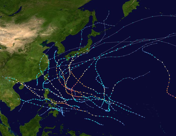 | ||
The 2014 Pacific typhoon season was a slightly below average season, featuring 23 tropical storms, 11 typhoons and 8 super typhoons. The season's peak months August and September saw a very low to no activity of tropical cyclones caused by an unusually strong and a persistent suppressing phase of the Madden-Julian Oscillation. The season ran throughout 2014, though most tropical cyclones typically develop between May and October. The season began with the development of Tropical Storm Lingling on January 18; and ended after Tropical Storm Jangmi which dissipated on January 1 of the next year.
Contents
- Seasonal forecasts
- Tropical Storm Lingling Agaton
- Tropical Storm Kajiki Basyang
- Typhoon Faxai
- Tropical Depression 04W Caloy
- Tropical Storm Peipah Domeng
- Severe Tropical Storm Tapah
- Tropical Storm Mitag Ester
- Tropical Storm Hagibis
- Typhoon Neoguri Florita
- Typhoon Rammasun Glenda
- Typhoon Matmo Henry
- Typhoon Halong Jose
- Severe Tropical Storm Nakri Inday
- Typhoon Genevieve
- Severe Tropical Storm Fengshen
- Tropical Depression 14W Karding
- Typhoon Kalmaegi Luis
- Tropical Storm Fung wong Mario
- Severe Tropical Storm Kammuri
- Typhoon Phanfone Neneng
- Typhoon Vongfong Ompong
- Typhoon Nuri Paeng
- Tropical Storm Sinlaku Queenie
- Typhoon Hagupit Ruby
- Tropical Storm Jangmi Seniang
- Other systems
- Storm names
- International names
- Philippines
- Season effects
- References
The season was not as active, deadly and costly as the previous typhoon season, but was notable for producing a series of powerful super typhoons. In fact, this season saw the most number of storms reaching Category 5 intensity (seven -- Neoguri, Rammasun, Halong, Genevieve, Vongfong, Nuri, and Hagupit) in Saffir–Simpson wind scale since 1997.
The scope of this article is limited to the Pacific Ocean to the north of the equator between 100°E and 180th meridian. Within the northwestern Pacific Ocean, there are two separate agencies that assign names to tropical cyclones which can often result in a cyclone having two names. The Japan Meteorological Agency (JMA) will name a tropical cyclone should it be judged to have 10-minute sustained wind speeds of at least 65 km/h (40 mph) anywhere in the basin, whilst the Philippine Atmospheric, Geophysical and Astronomical Services Administration (PAGASA) assigns names to tropical cyclones which move into or form as a tropical depression in their area of responsibility located between 135°E and 115°E and between 5°N–25°N regardless of whether or not a tropical cyclone has already been given a name by the JMA. Tropical depressions that are monitored by the United States' Joint Typhoon Warning Center (JTWC) are given a number with a "W" suffix.
Seasonal forecasts
Every year several national meteorological services and scientific agencies forecast how many tropical cyclones, tropical storms, and typhoons will form during a season and/or how many tropical cyclones will affect a particular country. These agencies include the Tropical Storm Risk (TSR) Consortium of the University College London, Philippine Atmospheric, Geophysical and Astronomical Services Administration (PAGASA) and the Taiwan's Central Weather Bureau. During October 2013, the Vietnamese National Center for Hydro Meteorological Forecasts (VNCHMF) predicted that one to two tropical cyclones would develop and possibly affect Vietnam between November 2013 and April 2014. Within its January — June seasonal climate outlook, PAGASA predicted that one to two tropical cyclones were likely to develop and/or enter the Philippine area of responsibility between January and March while three to six were predicted for the April to June period. During March the Hong Kong Observatory predicted that the typhoon season in Hong Kong, would be near normal with four to seven tropical cyclones passing within 500 km (310 mi) of the territory compared to an average of 6.
On May 5 and 6, China Meteorological Administration's Shanghai Typhoon Institute (CMA-STI) predicted that 26-28 tropical storms would develop over the basin, while Tropical Storm Risk issued their first forecast for the season and predicted an active typhoon season. As a result 27 tropical storms, 17 typhoons and 11 intense typhoons were predicted to occur, while an ACE Index of 375 was also predicted by TSR. In late June Taiwan's Central Weather Bureau predicted that 29-32 tropical storms would develop over the basin, while three-five systems were expected to affect Taiwan itself. Within its July — December seasonal climate outlook, PAGASA predicted that eight to ten tropical cyclones were likely to develop and/or enter the Philippine area of responsibility between July and September, while five to seven were predicted for the October–December period. Within its two final forecasts for 2014, Tropical Storm Risk predicted that 26 tropical storms, 16 typhoons and 9 intense typhoons would develop over the basin.
Tropical Storm Lingling (Agaton)
On January 10, the JMA reported that a tropical depression had developed, about 1,800 km (1,120 mi) to the southeast of Manila, Philippines. The JMA expected the system to develop into a tropical storm within 24 hours, despite it being located in an area of marginal conditions for further development. The JMA downgraded it back to a weak tropical disturbance on January 12, when convection became more disorganized. Although its remnants crossed Mindanao, Philippines on January 13 and emerged into the area off the northeast coast of Mindanao on the next day. The system intensified into a tropical depression again on January 15 with the poor structure under high vertical wind shear and strong northeasterly surges, and the JTWC issued a TCFA on the system on the next day, for the consolidating structure and more favorable conditions.
On January 17, PAGASA upgraded the system to a tropical depression and gave the local name Agaton. During the next day the JMA reported that the system had intensified into a tropical storm and named it Lingling. Six hours later, the JTWC upgraded Lingling to a tropical storm, based on the scatterometer data and Dvorak estimates. Half a day later, however, the JTWC downgraded Lingling to a tropical depression, for significantly diminishing convection. Late on January 19, the JTWC issued the final warning on Lingling. The system was last noted by the JMA, during January 20, as it dissipated to the southeast of the Philippines.
Despite not making landfall as a tropical cyclone on the Philippines, the system brought considerable rainfall over several days to southern Mindanao that caused six flooding and sixteen landslide incidents. As a result the majority of the 70 deaths caused by the system in the Philippines, were as a result of landslides or people drowning. Other impacts caused by Lingling (Agaton) included damage to 3482 houses and flooding to the irrigation dams in Cateel, Davao Oriental. Overall the total cost of damages was estimated at 7008566000000000000♠PHP566 million (7007125000000000000♠US$12.5 million) with damage to infrastructure estimated at 7008273000000000000♠PHP273 million and 7008293000000000000♠PHP293 million for agriculture.
Tropical Storm Kajiki (Basyang)
On January 29, the JMA reported that a tropical depression had developed about 475 km (295 mi) to the south-southeast of Hagåtña, Guam. Over the next day the system moved westwards within an area that was marginal for further development, with low to moderate vertical wind shear and moved into the Philippine area of responsibility. As a result PAGASA named the system Basyang during January 30, while the JTWC initiated advisories and designated the system as Tropical Depression 02W. The system subsequently continued to move westwards under the influence of the subtropical ridge of high pressure, before it reached its peak intensity as a tropical storm with wind speeds of 65 km/h (40 mph) during January 31. According to PAGASA, the storm made landfall over Siargao Island on January 31. Due to the unfavorable conditions in the South China Sea, Kajiki dissipated late on February 1.
Kajiki impacted the Philippines between January 30 and February 1, where a total of 13 landslides and 4 flooding incidents, were recorded in the provinces of Cebu and Southern Leyte. Overall six people were killed in the island nation while total damages were estimated at 9.14 million PHP (US$195 thousand).
Typhoon Faxai
On February 27, the JMA started to monitor a tropical disturbance, that had developed, about 630 km (390 mi) to the south-southeast of Hagåtña, Guam. During the following day, it was upgraded by the JTWC to a tropical depression, and designated as 03W. Several hours later, the JMA upgraded the system to a tropical storm and named it Faxai. Faxai began to rapidly intensify into a severe tropical storm, and then typhoon, for a short period of time on March 4. The system transitioned into an extratropical cyclone during March 6, before it dissipated during March 8, while located around 800 km (495 mi) to the northeast of Wake Island.
Despite passing well to the east of Guam, Faxai's wind and an enhanced wind flow to the north of the typhoon generated large swells, which claimed the life of a woman.
Tropical Depression 04W (Caloy)
Early on March 18, the JMA reported that a tropical depression had developed about 375 mi (605 km) to the east of Melekeok, Palau. Over the next few days, the system became more organised and it was named Caloy by PAGASA on March 21. Late on March 22, the system was designated as 04W by the JTWC. Due to less convection and land reaction on March 24, the system was downgraded to a disturbance and dissipated later that day. The remnant disturbance continued to move westwards before it was last noted on March 25, to the northeast of Bandar Seri Begawan, Brunei.
Tropical Storm Peipah (Domeng)
On March 30, a cluster of thunderstorms formed near the equator and Papua New Guinea. The large cluster separated into 2 systems, with the other strengthening into Cyclone Ita. It intensified into a tropical depression on April 2 and strengthened into 05W by the JTWC the next day. On April 4, convection built up and the system intensified into a tropical storm, prompting the JMA to name it Peipah. Two days later, the system entered into the Philippine Area of Responsibility, and was named Domeng by PAGASA. Early on April 9, Peipah weakened to a tropical depression. Later on April 10, the JMA declared that Peipah had dissipated as the JTWC classifies that it is still a tropical depression. The PAGASA and JTWC issued its final warning on Peipah later that day, while the storm's remnants continued to move slowly northwestward towards the eastern Philippines. Late on April 13, the remnants of Peipah regenerated into a tropical depression to the east of the Philippines, while slowly continuing to approach the island nation. On April 15, the depression became disorganized and the system's convection was displaced from its center of circulation, prompting the JTWC to issue its final advisory on the system. During the next several hours, the remnants of the depression turned towards the southwest, until it dissipated late on April 15, just off the northeastern coast of the island of Mindanao.
Severe Tropical Storm Tapah
Early on April 27, the JMA reported that a tropical depression had formed about 420 km (260 mi) to the south-southeast of Hagåtña, Guam. Later that day, the JTWC upgraded it to Tropical Depression 06W as it moved north. Due to warm waters, the system rapidly intensified into a tropical storm with the JMA naming it Tapah on April 28. Later that day, convection occurred and the system was upgraded to a severe tropical storm. Early on April 29, the JTWC upgraded Tapah into a minimal typhoon. It weakened back to a tropical storm during April 30. During May 1, the system weakened into a tropical depression because of the effects of strong vertical windshear and a decrease in sea surface temperatures, before the JTWC issued their final advisory on the system. The system was subsequently last noted by the JMA during the next day, as it dissipated over 1,300 km (810 mi) to the south-east of Tokyo, Japan.
Tropical Storm Mitag (Ester)
Late on June 6, a low-pressure area formed near the island of Hainan, China, embedded from the monsoon trough. The next day, the system slowly moved in an eastward direction. Early on June 9, the JMA reported that it intensified into a tropical depression which had developed about 115 km (71 mi) to the south-southeast of Hengchun, Taiwan. On June 10, PAGASA named the system Ester, as it brought flooding to the Philippines. On the night of the next day, convection increased to the system as the JMA upgraded to Tropical Storm Mitag. In the same time, the JTWC classified it as subtropical. The system was last noted by the JMA during June 12, as the system was absorbed by a developing extratropical cyclone located north of Japan.
There was no damage reported in association with Tropical Storm Mitag (Ester) in the Philippines, however, it did prompt PAGASA to declare the official start of the rainy season on June 10, 2014.
Tropical Storm Hagibis
Similar to the formation of Mitag, a small circulation started to develop in the South China Sea, late on June 8. Early on June 11, the system was upgraded to a tropical disturbance. On June 13, the JMA classified the storm as a tropical depression, as it started to move slowly towards the northeast. Early on June 14, the JTWC issued a TCFA alert on the tropical depression. Later that day, the JTWC upgraded the storm to Tropical Depression 07W, and at the same time, the JMA upgraded it to a tropical storm, naming it Hagibis. Early on June 15, Hagibis made landfall over southern China. During the next day, both agencies stopped issuing warnings on the system, as it rapidly weakened to a tropical depression over land. Its remnants still continued to move northward, by on June 17, the remnants of Hagibis curved eastwards, as it re-generated into a tropical storm. As a result, the JMA reinitiated advisories on Hagibis. Late on June 17, Hagibis transitioned into an extratropical cyclone. On June 21, the remnants of the storm were absorbed by another developing extratropical cyclone to the north. The system moved out of the basin on June 23.
About 13,000 people were affected by the storm. Economic losses from Hagibis reached a total of 577 million yuan ($93 million USD). Two days later, it was topped to 675 million yuan ($103.3 million USD), and reached a total of $131 million as of June 20. As of June 19, the Chinese Government had reported that there were 11 casualties in regions affected by Hagibis.
Typhoon Neoguri (Florita)
A weak tropical disturbance formed near Guam on June 30. On July 1, it further intensified due to warm sea-surface temperatures and convection, and it was upgraded to a tropical depression late on July 2. The next day, it was classified as Tropical Depression 08W by JTWC. Early on July 4, it was upgraded to a tropical storm by the both agencies, with the latter naming it as Neoguri. Later that day, Neoguri rapidly intensified into a minimal typhoon. Early on July 5, it once again rapidly intensified and was upgraded to Category 4 status by the JTWC as the eye developed clearly. In the same time, the storm entered the PAR, with PAGASA giving it the name Florita. Late the next day, Neoguri entered an area of very warm sea temperatures and intensified into a super typhoon. The storm reached peak intensity early on July 7, which the JTWC operationally assessed as 1-minute winds of 250 km/h (155 mph). Early on July 8, Neoguri weakened to a Category 3 typhoon, and PAGASA stated that the storm had exited their area later that day. Late the next day, Neoguri further weakened to a severe tropical storm by the JMA. Due to the strong jet stream, Neoguri moved in an eastward direction instead of moving towards Korea. On July 10, JMA downgraded the system to a tropical storm as the JTWC made their final warning and stopped issuing advisories, as it showed signs that it was becoming extratropical. At the same time, Neoguri's circulation became totally exposed as it was affecting southern Japan. The JMA made their final warning early on July 11, as Neoguri became extratropical. The extratropical remnants of Neoguri collided with another weak, developing system north of it late on July 13.
In June 2015, the JTWC upgraded Neoguri to a Category 5 super typhoon in its post-analysis.
Typhoon Rammasun (Glenda)
Typhoon Rammasun originated from an area of disturbed weather roughly 280 km (175 mi) east of Chuuk State in the Federated States of Micronesia on July 9, 2015. Classified as a tropical depression by the JMA that day, the system moved northwest toward the Mariana Islands. The poorly organized system passed directly over Guam on July 11 before turning due west in response to a subtropical ridge farther north. Subsequent convective deepening and enhancement of banding features resulted in the system's classification as a tropical storm on July 12. Accordingly, the JMA assigned the name Rammasun to the storm. Acquiring a slight southerly component to its track, Rammasun gradually intensified over the following days. Owing to its proximity to the Philippines, PAGASA began monitoring the storm on July 13 and assigned it the local name Glenda. The system achieved typhoon strength on July 14 after a 27 km (17 mi) wide eye formed. Rapid intensification ensued on July 15 as Rammasun struck the Bicol Region of the Philippines. Winds at landfall reached 155 km/h (100 mph) according to the JMA; however, the JTWC indicated Rammasun to be much stronger with one-minute sustained winds of 215 km/h (130 mph).
Turning back to the west-northwest, Rammasun weakened significantly as it traversed the Philippines. The system emerged over the South China Sea on July 16 with its eye no longer visible on satellite imagery. After briefly weakening to a severe tropical storm, favorable environmental conditions allowed for reorganization. Rammasun reached its peak intensity on July 18 as it approached southern China. Featuring a well-defined eye surrounded by deep convection and prominent outflow, the JMA estimated the typhoon's winds at 165 km/h (105 mph) along with a barometric pressure of 935 mbar (hPa; 27.61 inHg). The JTWC reported Rammasun to be substantially stronger with peak one-minute winds of 250 km/h (155 mph), just shy of Category 5 status on the Saffir–Simpson hurricane wind scale. However, on its July 2015 best track, this was increased to 260 km/h (160 mph), making Rammasun a Category 5 super typhoon. Weakening took place thereafter with the storm clipping Hainan Island and later striking Guangxi Province. Rammasun degraded to a tropical storm after moving ashore and ultimately dissipated on July 20 over Yunnan Province.
As of July 17, it is reported from NDRRMC that the death toll has reached 40 and the total amount of damages were amounted to 1 billion pesos ($27 million USD). In China, 18 persons were killed due to the storm. Total damages amounted to $7 billion USD. Rammasun killed nearly 200 people.
Typhoon Matmo (Henry)
Late on July 13, the Intertropical Convergence Zone spawned another tropical disturbance. But due to Typhoon Rammasun being nearby, the disturbance started to weaken. The next day, it gathered warm waters and favorable conditions. Very early on July 16, the JMA upgraded the system to a weak tropical depression, as it started to show signs of intensification. At the same time, the JTWC issued a TCFA on the system. The next day, the JTWC upgraded the system to Tropical Storm 10W, while the JMA named the system Matmo, after it strengthened to a tropical storm. Early on July 18, Matmo entered the PAR, with PAGASA giving it the name Henry. On July 19, the JMA upgraded the system to a severe tropical storm. During the next day, Matmo began to slowly intensify to a typhoon. The JTWC, on the other hand, still classified the system as a tropical storm. Later that day, the JTWC upgraded it to a Category 1 typhoon. At the same time, Matmo curved towards the northwest. Late on July 22, the JMA downgraded Matmo to a severe tropical storm. Early the next day, the JTWC instead upgraded Matmo to a Category 2, as the storm re-intensified. With that, a small unclear eye developed in Matmo's center.
One person was reported dead and there was some damage reported. At least 48 people died in a plane crash in the Taiwan strait; the crash may have been caused by the typhoon. As of July 24, according to the Yilan County Government, the agricultural damage in the county was estimated at about NT$44 million ($1.5 million USD).
Typhoon Halong (Jose)
On July 26, the JMA began to monitor a low-pressure area near Chuuk. After the system stalled for a few days, it was upgraded to a tropical depression on July 27. Early on July 29, the depression showed signs of intensification and with that, the JTWC upgraded it to Tropical Storm 11W. Later that day, the JMA upgraded 11W to Tropical Storm Halong. At the same time, Halong started developing a small, unclear eye. Around this time, gale and typhoon force winds were reported over Guam. For over 24 hours, Halong's intensification stalled due to unfavorable upper-level winds and strong vertical wind shear. Very late on July 30, JMA upgraded Halong to a severe tropical storm, as the storm resumed its intensification. During the next day, both agencies upgraded Halong to a minimal typhoon. At the same time, Halong started undergoing rapid deepening. On August 2, Halong's developed a clearer eye, and then it intensified to a Category 2 typhoon in less than 24 hours. At the same day, due to excellent equatorial outflow and favorable conditions, it rapidly intensified into a Category 5 super typhoon. At the same time, PAGASA had reported that Halong had entered their area of responsibility, and assigned it the name Jose. On August 4, Halong underwent an eyewall replacement cycle and consequently, it weakened to a Category 4 typhoon. The next day, Halong weakened to a minimal typhoon, although it was a deep typhoon due to its pressure. In the same day, its convection was steadily weakening. On August 6, NASA has reported that Halong was beginning to replace a new eye. This made the JTWC upgraded it to a category 2 typhoon again. Its eye continued to undergo the eyewall replacement cycle until August 8. In the same day, Halong weakened to a category 1 and started to affect mainland Japan. The JTWC downgraded Halong to a tropical storm on August 9, while the JMA followed suit several hours later. Halong made landfall over the southern part of Japan prior to August 10. On August 10, JTWC made their final bulletin on Halong, as it was leaving the country. Early on August 11, the JMA reported that Halong had transitioned into an extratropical cyclone while it was located to the northeast of Tokyo, Japan. Over the next couple of days the system moved westwards and moved into the Sea of Okhotsk, before it was last noted by the JMA during August 15, as it moved into the Pacific Ocean.
Severe Tropical Storm Nakri (Inday)
On July 19, a tropical depression formed to the southeast of Guam. It slowly moved in a northwest direction over the next few days. Early on July 22, the JTWC issued a TCFA Alert, but later that day, the system lost its organization, and was downgraded to a low pressure area. Early on July 24, the low-pressure area re-formed east of Palau. JMA upgraded the system to a tropical depression early on July 26, as it started to move in a northward direction. The depression continued to intensify, even though it didn't reach tropical storm strength. Due to weakening convection east of the storm's center, it started to weaken on July 28. Later that day, more convection increased in the western side of the storm, and it began to reintensify. On July 29, the JMA upgraded the system to Tropical Storm Nakri. The JTWC, on the other hand, still classified it as a disturbance or a monsoonal depression, even while deep convection was occurring in Nakri. Due to the deep pressure of Nakri, the JMA upgraded it to a severe tropical storm on July 31. On August 2, the JTWC issued advisories of Nakri, and was given the designation 12W. The next day, Nakri encountered strong vertical windshear which caused the storm to weaken. Later that day, the JTWC issued their final advisory. The JMA followed suit the next day.
Typhoon Genevieve
On August 7, Hurricane Genevieve entered the West Pacific basin at Category 4 super typhoon status. Later that day, the Joint Typhoon Warning Center (JTWC) upgraded the system to a Category 5 super typhoon. Genevieve entered an area of favorable conditions and low vertical windshear, as it continued to intensify. Later on August 7, Genevieve reached its peak intensity, with winds of 110 knots (205 km/h; 125 mph), and with this, it became the third strongest storm within the Northwest Pacific in 2014. On August 9, Genevieve started to move in a northward direction, towards low to moderate vertical windshear. Later that day, the JTWC downgraded the system to a category 3 typhoon. Later that day, Genevieve rapidly weakened to a strong Category 2 typhoon, as it began to encounter increasing windshear and drier inflow, to the south of the system. At the same time, the eye of the typhoon began to shrink. On August 10, Genevieve weakened to a minimal typhoon, as it began to develop a secondary eye, but the secondary eye soon disappeared, due to the storm moving over cooler waters. Both agencies downgraded the system to a severe tropical storm later that day, and rapidly weakening to a minimal tropical storm on August 11. Later that day, Genevieve started to lose its identity, and showed a bit of subtropical characteristics. With this, JTWC issued their final advisory on the storm. However, JMA tracked Genevieve until August 14, as it interacted with a high-pressure area. The remnant energy of Genevieve continued and was absorbed by a developing low-pressure area north of it on August 15.
Severe Tropical Storm Fengshen
An area of convectional cloudiness persisted near Palau on the end of August. On September 1, it was dubbed into a disturbance and had entered an area of favorable environments of developing further in the next couple of days. The disturbance wandered in the west Philippine Sea and moved northwards, while intensifying. On September 5, JMA upgraded it to a tropical depression. The next day, JTWC issued a TCFA Alert, as it steadily intensifies with enough convection and still favorable conditions. During September 7, JMA upgraded it to Tropical Storm Fengshen, as JTWC designates it as 13W. Due to strong thunderstorms and enough convection, Fengshen steadily intensified. On September 9, Fengshen reached its peak intensity as a severe tropical storm, without becoming a typhoon as it even created an eye. Although the storm reached severe tropical storm strength, Fengshen collided with a developing front and started to weaken east of Japan. Both the JMA and the JTWC issued their final warnings on Fengshen, as it becomes an extratropical storm.
Tropical Depression 14W (Karding)
Late on September 5, the JMA reported that a tropical depression had developed out of an area of low pressure that had crossed central Luzon and was now located about 430 km (265 mi) to the south-west of Manila. During the next day, JTWC issued a TCFA while PAGASA named the depression Karding. JTWC classified it as Tropical Depression 14W on September 7, due to strong banding clouds surrounding the center. Although this did not continue as JMA made their final warning due to the large amount of disorganization.
Typhoon Kalmaegi (Luis)
On September 10, a tropical disturbance formed northeast of Palau with a possibility of becoming a tropical cyclone in the next few days. Later the same day, the JTWC had reported that it had intensified into a tropical depression, giving the designation "15W". Early on September 12, the JMA finally started to track 15W as a tropical depression. In the same time, PAGASA had issued their first advisories on the storm, naming it as Tropical Depression Luis. As Luis entered a more conducive environment, it had steadily intensified into a tropical storm and was named Kalmaegi by the JMA later that day and the JTWC followed suit on the same day. The storm entered an area of warm waters as the JMA upgraded it to a typhoon, while JTWC upgraded it to a category 1 typhoon late on September 13. Kalmaegi made landfall over Cagayan early the next day, as it start to interact with land and weakened to a tropical storm. On September 15, Kalmaegi entered the South China Sea and intensified again. Although, Kalmaegi intensified with a deep pressure. The typhoon reached its peak strength, while making its second landfall over Hainan Island. Kalmaegi rapidly weakened to a large tropical storm as it continued to move in a westward direction. Both agencies classified Kalmaegi as a tropical depression and had dissipated later that day.
Tropical Storm Fung-wong (Mario)
Late on September 13, an area of convectional cloudiness persisted near the same position where Kalmaegi formed. The next day, JTWC upgraded it as a tropical disturbance. The system entered an area of moderate vertical windshear and towards warm waters, as it was upgraded into a tropical depression by the JMA early on September 17. On the same day, the depression moved into the Philippine Area of Responsibility and was locally named, Mario. Later the same day, JTWC classified it as Tropical Depression 16W. As vertical windshear decreased around the storm system, it gathered more strength. With this, JMA classified it as a tropical storm, naming it Fung-wong on September 18. Fung-wong maintained its intensity while affecting Luzon. The storm made landfall in the night of the next day over the northern tip of Cagayan. Early on September 20, JMA upgraded it to severe tropical storm strength, although it failed to intensify and reached its peak strength later that day. However, it was recorded colder cloud tops surrounding the center is still bringing heavy rainfall over northern Philippines. The storm made landfall on the shores of the southeastern part of Taiwan the next day. Fung-wong later weakened due to land reaction. Late on September 22, Fung-wong encountered some moderate vertical windshear and approached Eastern China. Both agencies downgraded Fung-wong to a tropical storm, just as it was making landfall over Shanghai on September 23. On September 24, Fung-wong started to interact with a frontal system. Later on the same day, both the JMA and JTWC issued their final advisory on the system, stating that it had become extratropical.
Just like Karding, it was reported hail in Makati on September 18, due to the western outflow and thunderstorms of Fung-wong. Severe flooding has occurred in many places in Luzon, especially Manila following the aftermath of Typhoon Kalmaegi.
Severe Tropical Storm Kammuri
Similar to the formation of Fung-wong, an area of convectional cloudiness persisted on September 19. On September 22, both the JMA and JTWC starts to monitor a tropical disturbance over the Mariana Islands within that area or convection. The JMA had upgraded it to a tropical depression, as it starts to show signs of intensification early on September 23. This continued until on September 24, when the JMA upgraded the storm to Tropical Storm Kammuri, while the JTWC designated the system as 17W. As the low-level circulation improved, Kammuri became more organized. With this, a large eye started to develop. On September 26, the JMA upgraded the system to a severe tropical storm. Later that day, Kammuri reached its peak intensity. On September 27, Kammuri started to interact with the outflow of the extratropical remnants of Fung-wong, as well as vertical windshear, which caused Kammuri to weaken. On the next day, the JMA downgraded Kammuri to a tropical storm, as the system continued to weaken. On September 30, Kammuri transitioned into an extratropical cyclone, prompting the JMA to issue its final advisory on the storm.
Typhoon Phanfone (Neneng)
On September 26, a large area of convection persisted well west of the International Dateline. In the same time, JTWC had classified it as a tropical disturbance. The JMA classified this to a tropical depression on September 28, while the JTWC designated it as 18W the next day. On September 29, 18W intensified into Tropical Storm Phanfone, due to very favorable conditions and intense thunderstorms rich with convection surrounding the storm's center. Due to these factors, Phanfone continued displaying signs of intensification later that day. Phanfone strengthened into a minimal typhoon late on September 30. But due to warm sea-surface temperatures and very favorable environments, Phanfone underwent rapid deepening on October 1. The next day, Phanfone strengthened into a category 4 typhoon. However, the storm then weakened to a category 3. This is due to its eye replacing the old one and undergoing a minor eyewall replacement cycle, although the JTWC upgraded Phanfone to a category 4 again late on October 3. In the same time, Phanfone entered the PAR, with PAGASA assigning the name Neneng, although the storm exited the basin several hours later. On October 4, Phanfone reached its peak intensity, with the JTWC classifying it as a super typhoon. After it affected Japan, the JTWC issued its last advisory on the system, as it tracked noreastward and extremely affected by a strong vertical wind shear.
Typhoon Vongfong (Ompong)
On September 30, the JTWC had been monitoring a weak tropical disturbance which formed from the Intertropical Convergence Zone. The system steadily intensified as it moved towards favorable environments and warm waters. On October 2, the JMA upgraded the system to a tropical depression. Later that day, the JTWC classified it as Tropical Storm 19W. 19W soon intensified into a tropical storm, with the JMA naming it Vongfong upon its intensification into a tropical storm. Due to a strong outflow, Vongfong intensified into a minimal typhoon, even as it affected the Mariana Islands. Warnings were canceled in the area, as Vongfong moved in a westward direction. The next day, Vongfong entered an area of warm waters. This allowed the system to enter a rapid deepening phase, and as a result, it was upgraded to a Category 3 typhoon by the JTWC later that day. Late on October 7, PAGASA declared that Vongfong had entered their area of responsibility, and named it Ompong. Early on October 8, Vongfong intensified from a Category 3 to a Category 5 super typhoon. This also made Vongfong the most powerful tropical cyclone of 2014, and the most intense since Typhoon Haiyan. Although Vongfong maintained its intensity, the typhoon undergo an eyewall replacement cycle and this made Vongfong to weaken late the next day. On October 10, the JTWC downgraded Vongfong to a category 3 typhoon, as its convection started to weakened slightly. This also made the system weakened to a category 2 typhoon early on October 11, and passed by the island of Okinawa. Due to drier inflow, Vongfong weakened to a weak typhoon. Vongfong made landfall over southwestern Japan on October 13, just as both agencies downgraded it to a strong tropical storm. Dry air surrounded to southern periphery of Vongfong as the JMA issued its final advisory. The JTWC followed suit as the system became fully extratropical on October 14. The extratropical remnants of Vongfong exited the West Pacific basin three days later.
Typhoon Nuri (Paeng)
Late on October 28, the JTWC spotted a weak tropical disturbance east of Guam. The next day, it had consolidated over favorable environments, whereas the JMA classified the disturbance as a tropical depression on October 30. On the following day, the JTWC issued warnings on the tropical depression, which was designated as 20W. Later that day, the JMA upgraded 20W to Tropical Storm Nuri, as the JTWC had later followed suit. Early on November 1, Nuri gradually intensified as it entered the PAR, with PAGASA naming it Paeng. Later that day, the JMA upgraded the storm to a severe tropical storm. Due to an increase of convective activity, Nuri had intensified into a typhoon. On November 2, Nuri had undergone a phase of rapid deepening and dropped 55 millibars in one day. This also made the JTWC upgrade Nuri to a Category 4 typhoon. On November 3, Nuri continued to intensify and reached Category 5 strength, as it started to move in a northward direction. Later that day, Nuri reached its peak intensity, with maximum sustained winds of 285 km/h (180 mph) and tied with Vongfong. Some shear and cool sea-surface temperatures caused Nuri to weaken early on November 3. The next day, both the JMA and the JTWC downgraded Nuri to a category 3 typhoon. Around that time, the storm underwent an eyewall replacement cycle. Nuri quickly weakened due to vertical wind shear and by November 6, the tropical storm had begun extratropical transition. The next day, the low-level circulation center split, and the new center absorbed the old center later that day. The unusually powerful pacific jet stream powered the system, which became the strongest extratropical cyclone ever recorded over the Bering Sea.
Tropical Storm Sinlaku (Queenie)
On November 23, a cluster of thunderstorms was located near the equator. Late on November 24, a broad area of low-pressure develops well east of Mindanao, Philippines. On November 26, the area gradually developed convection near its center and PAGASA had upgraded it to Tropical Depression Queenie. Later the same day, both the JMA and the JTWC classified Queenie as a tropical depression, with the JTWC also designating it as 21W. On November 28, the JMA upgraded the system to a tropical storm, assigning the name Sinlaku, while the JTWC followed suit. Due to low vertical windshear, Sinlaku gathered strength while it was on the South China Sea. The next day, convective activity increased near the storm's center. In the same time, the JMA upgraded Sinlaku to a severe tropical storm, however according to its best track, the JMA peaked its intensity as a strong tropical storm. Later that day, Sinlaku made landfall over Vietnam as it started to weaken. Both agencies downgraded the system to a tropical depression early on November 30 and made their final advisories later that day.
Typhoon Hagupit (Ruby)
Late on November 29, a tropical disturbance was located just north of the equator near Chuuk. The next day, the system entered an area of favorable environment and it had rapidly developed even further. With this, the JTWC issued a Tropical Cyclone Formation Alert on the disturbance. On December 1, both the JMA and the JTWC upgraded it to a tropical depression and was given the designation 22W by the JTWC. It was later upgraded into a tropical storm by the JTWC, and was later named Hagupit by the JMA as they followed suit. During the same time, Hagupit rapidly deepened by 50 mbars, from a minimal typhoon to a Category 5 super typhoon early on December 4 as a clear and well-defined eye developed. Later the same day, Hagupit entered the PAR, with PAGASA giving the name Ruby. Very early on December 6, Hagupit reached its maximum intensity with a pressure down to 905 millibars and 1-min sustained winds of 285 km/h (180 mph), which was the same as Vongfong and Nuri's intensity. Later that day, Hagupit encountered moderate vertical windshear from the east and started an eyewall replacement cycle as it weakened to a Category 4 super typhoon intensity. The JTWC downgraded Hagupit to a Category 3 typhoon just before December 7. Moreover, a slight break in the steering and the zonal flow along the southern periphery of the mid-latitude trough lacked the dynamics to influence Hagupit, making the typhoon move in a slow westward direction. Nearly the same time, Hagupit made landfall over Eastern Samar and encountered land reaction, as it further weakened to a Category 2 typhoon. Hours later, the system moved in a northwestward direction and made its second landfall over Masbate. The next day, both agencies downgraded Hagupit to a strong tropical storm, due to its continued slow movement and land reaction. During the same time it weakened to a tropical storm, Hagupit made its third landfall over the island of Marinduque. During its fourth landfall over Batangas, the JMA downgraded it to a tropical storm.
On December 9, Hagupit entered the South China Sea, retaining its tropical storm intensity. Although due to an increase of deep convection near the center, the JMA upgraded Hagupit again to a severe tropical storm early on December 10. Later that day, the JMA downgraded it again to a minimal tropical storm. The next day, both agencies downgraded the storm to a tropical depression, as it started to do a southwestward direction towards Vietnam. On December 12, the JTWC issued its final warning on Hagupit. The JMA tracked it until it dissipated just southeast of Ho Chi Minh City, Vietnam later the same day.
Tropical Storm Jangmi (Seniang)
On December 27, the JMA started to monitor a tropical depression, that had developed within a favourable environment for further development, about 630 km (390 mi) to the west of Koror, Palau. Over the next day the depression gradually developed further and was named Seniang by PAGASA as it moved along a ridge of high pressure, while atmospheric convection wrapped into the system's low level circulation centre. Both the JTWC and PAGASA upgraded the depression to a tropical storm late on the same day. Early on December 29, the JMA upgraded the system to a tropical storm, naming it Jangmi. At the time of the upgrade, Jangmi made landfall over the town of Hinatuan in the province of Surigao del Sur. The storm traversed the CARAGA region, and exited the landmass of Mindanao during the afternoon hours of the same day, as the storm had accelerated to the northwest. Late on December 30, Jangmi made landfall over Cebu and southern Negros, right before the JTWC downgraded it to a tropical depression. On December 31, the JTWC issued the final warning to Jangmi, as well as the JMA downgraded it to a tropical depression at noon. The system was last noted by the JMA and the JTWC on January 1, 2015, as the 2015 Pacific typhoon season started.
Other systems
During March 11, the JMA monitored a tropical depression that had developed about 195 km (120 mi) to the east of Mati City, Philippines. Over the next day the system moved westwards, before it was last noted within the Celebes Sea on March 12. On April 19, the JMA reported that a tropical depression had developed about 490 km (300 mi) southwest of Hagåtña, Guam. Due to less convection and cool waters on April 21, the depression weakened to a disturbance while still moving west. The remnants of the depression affected the northern Philippines and dissipated on April 23, due to land interaction. On August 19, the JMA briefly monitored a tropical depression, that had developed along the coast of China to the northeast of Hong Kong. Convectional cloudiness persisted over the Philippines, contributing to bring heavy rainfall on August 25. The area intensified into a low-pressure area as it moved to the South China Sea the next day. It was classified as a tropical depression on August 27 by the JMA. The depression affected Hainan Island, Southern China and northern Vietnam by heavy rainfall and flash floods as it was moving in a westward direction. On August 29, the system weakened to an remnant low just east of the 100th meridian east.
A low-pressure area formed from an upper-level low several kilometers east-southeast of Japan on August 31. It started to organize and the southern part of the system has winds of tropical depression strength. On September 4, JMA upgraded it to a tropical depression. Although the system moved into an area of moderate vertical wind shear. With this, the system became extratropical late on September 5.
Storm names
Within the North-western Pacific Ocean, both the Japan Meteorological Agency (JMA) and the Philippine Atmospheric, Geophysical and Astronomical Services Administration assign names to tropical cyclones that develop in the Western Pacific, which can result in a tropical cyclone having two names. The Japan Meteorological Agency's RSMC Tokyo — Typhoon Center assigns international names to tropical cyclones on behalf of the World Meteorological Organization's Typhoon Committee, should they be judged to have 10-minute sustained windspeeds of 65 km/h (40 mph). While the Philippine Atmospheric, Geophysical and Astronomical Services Administration assigns names to tropical cyclones which move into or form as a tropical depression in their area of responsibility located between 135°E and 115°E and between 5°N-25°N even if the cyclone has had an international name assigned to it. The names of significant tropical cyclones are retired, by both PAGASA and the Typhoon Committee. Should the list of names for the Philippine region be exhausted then names will be taken from an auxiliary list of which the first ten are published each season. Unused names are marked in gray.
International names
During the season 22 tropical storms developed in the Western Pacific and each one was named by the JMA, when the system was judged to have 10-minute sustained windspeeds of 65 km/h (40 mph). The JMA selected the names from a list of 140 names, that had been developed by the 14 members nations and territories of the ESCAP/WMO Typhoon Committee. After the season the Typhoon Committee retired the name Rammasun and replaced it with Bualoi.
Philippines
During the season PAGASA used its own naming scheme for the 19 tropical cyclones, that either developed within or moved into their self-defined area of responsibility. The names were taken from a list of names, that had been last used during 2010 and are scheduled to be used again during 2018. The names Jose, Karding, Mario and Ruby were used for the first time during the year after the names Juan, Katring, Milenyo and Reming were retired.
At the start of 2014 the name Kanor was originally scheduled to replace Katring, however, PAGASA replaced it with the name Karding during September, after obtaining negative feedback from the public. After the season the names Glenda, Jose, Mario, Ruby and Seniang were retired by PAGASA, as they had caused over PhP1 billion in damages. They were subsequently replaced on the list with the names Gardo, Josie, Maymay, Rosita and Samuel.
Season effects
This table will list all the storms that developed in the northwestern Pacific Ocean west of the International Date Line and north of the equator during 2014. It will include their intensity, duration, name, areas affected, deaths, and damage totals. Classification and intensity values will be based on estimations conducted by the JMA. All damage figures will be in 2014 USD. Damages and deaths from a storm will include when the storm was a precursor wave or an extratropical low.