
3,000+ 3,000 Result Ceasefire since 2003. | Start date April 13, 1984 | |
 | ||
846 dead (including non-combat fatalities)36 casualties during combat (1984) 213 dead (including non-combat fatalities between 2003 and 2010)200 casualties during combat (1984) Similar Indo‑Pakistani wars and conflicts, Operation Meghdoot, Kargil War, Kashmir conflict, Indo‑Pakistani War of 1947 | ||
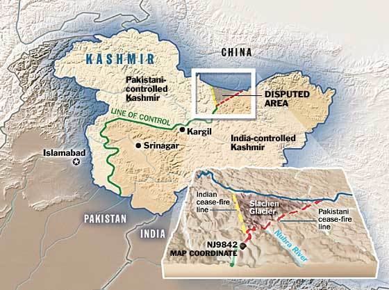
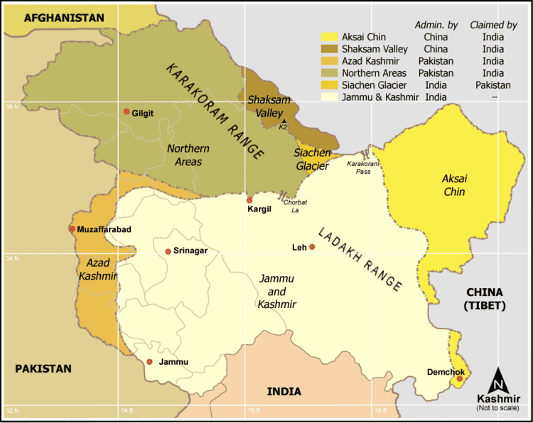
The Siachen conflict, sometimes referred to as the Siachen War, is a military conflict between India and Pakistan over the disputed Siachen Glacier region in Kashmir. A cease-fire went into effect in 2003. The contentious area is about 900 square miles (2,300 km2) to nearly 1,000 square miles (2,600 km2) of territory. The conflict began in 1984 with India's successful Operation Meghdoot during which it gained control over all of the Siachen Glacier (unoccupied and undemarcated area). India has established control over all of the 70 kilometres (43 mi) long Siachen Glacier and all of its tributary glaciers, as well as the three main passes of the Saltoro Ridge immediately west of the glacier—Sia La, Bilafond La, and Gyong La. Pakistan controls the glacial valleys immediately west of the Saltoro Ridge. According to TIME magazine, India gained more than 1,000 square miles (3,000 km2) of territory because of its military operations in Siachen.
Contents
- Siachen conflict complete show
- Causes
- Paragraph B 2 d of Karachi Agreement
- UN map of ceasefire line
- Oropolitics
- Historic maps of Siachen Glacier
- Military expeditions
- Major combat operations
- Ground situation
- Severe conditions
- Kargil War
- Visits
- Artistic depiction
- List of post ceasefire avalanches and landslides
- 2012 2014
- 2015
- 2016
- Operations
- References
Siachen conflict complete show
Causes
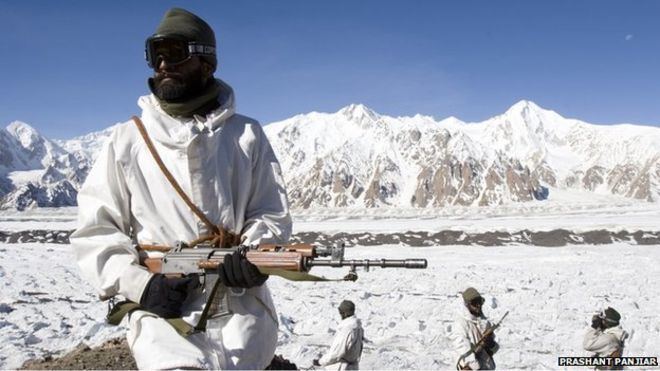
The Siachen Glacier is the highest battleground on earth, where India and Pakistan have fought intermittently since April 13, 1984. Both countries maintain permanent military presence in the region at a height of over 6,000 metres (20,000 ft). More than 2000 people have died in this inhospitable terrain, mostly due to weather extremes and the natural hazards of mountain warfare.
The conflict in Siachen stems from the incompletely demarcated territory on the map beyond the map coordinate known as NJ9842 (35.008371°N 77.008805°E / 35.008371; 77.008805). The 1949 Karachi Agreement and 1972 Simla Agreement did not clearly mention who controlled the glacier, merely stating that the Cease Fire Line (CFL) terminated at NJ9842. UN officials presumed there would be no dispute between India and Pakistan over such a cold and barren region.
Paragraph B 2 (d) of Karachi Agreement
Following the UN-mediated ceasefire in the 1949, the line between India and Pakistan was demarcated up to point NJ9842 at the foot of the Siachen Glacier. The largely inaccessible terrain beyond this point was not demarcated, but delimited as thence north to the glaciers in paragraph B 2 (d) of the Karachi Agreement.
Paragraph B 2 (d) of 1949 Karachi Agreement states:
(d) From Dalunang eastwards the cease-fire line will follow the general line point 15495, Ishman, Manus, Gangam, Gunderman, Point 13620, Funkar (Point 17628), Marmak, Natsara, Shangruti (Point 1,531), Chorbat La (Point 16700), Chalunka (on the Shyok River), Khor, thence north to the glaciers. This portion of the cease- fire line shall be demarcated in detail on the basis of the factual position as of 27 July 1949, by the local commanders assisted by United Nations military observers.
Later, following the Indo-Pakistani War of 1971, and the Simla Agreement in July 1972, the ceasefire line was converted into the "Line of Control" extending from the "Chhamb sector on the international border [to] the Turtok-Partapur sector in the north." The detailed description of its northern end stated that from Chimbatia in the Turtok sector "the line of control runs north-eastwards to Thang (inclusive to India), thence eastwards joining the glaciers." This vague formulation further sowed the seed for the bitter dispute to follow. The general description of CFL given in Section 1 of Karachi Agreement is further explained at Page 38 where it states:
"thence northwards along the boundary line going through Point 18402 up to NJ-9842"
The U.N. document number S/1430/Add.2. is the second addendum to the 1949 Karachi Agreement, and shows the CFL marked on the Map of the State of Jammu and Kashmir as per the explanation of CFL in paragraph 'B' 2 (d) of the Karachi Agreement.
U.N. map of ceasefire line
Title of U.N. document number S/1430/Add.2 which illustrates the CFL as per the Karachi Agreement reads:
Map of the State of Jammu and Kashmir showing the Cease Fire Line as Agreed Upon in the Karachi Agreement, Ratified by the Governments of India and Pakistan on 29 and 30 July Respectively. (See Annex 26 to the third Interim Report of the United Nation Commission for India and Pakistan)
A U.N. map showing CFL alignment superimposed on a satellite image depicts the CFL terminating at NJ9842. The extension of this line "thence north to the glaciers" never appeared on any authoritative map associated with either the 1948 or 1972 agreements, just in the text.
Oropolitics
In 1949, a Cease-Fire Line Agreement (CFL) was signed and ratified by India, Pakistan and the UN Military Observer Group that delineated entire CFL. In 1956-58, a scientific team led by the Geological Survey of India recorded its findings publicly including information about the Siachen and other glaciers.
After Pakistan ceded Shaksgam Valley to China in a boundary agreement in 1963, Pakistan started giving approval to western expeditions to the east of mountain K2. In 1957 Pakistan permitted a British expedition under Eric Shipton to approach the Siachen glacier through the Bilafond La, and recce Saltoro Kangri. Five years later a Japanese-Pakistani expedition put two Japanese and a Pakistani Army climber on top of Saltoro Kangri. These were early moves in this particular game of oropolitics.
In the 1970s and early 1980s several mountaineering expeditions applied to Pakistan to climb high peaks in the Siachen area due in part to US Defense Mapping Agency and most other maps and atlases showing it on the Pakistani side of the line. Pakistan granted a number of permits. This in turn reinforced the Pakistani claim on the area, as these expeditions arrived on the glacier with a permit obtained from the Government of Pakistan. Teram Kangri I (7,465 m or 24,491 ft) and Teram Kangri II (7,406 m or 24,298 ft) were climbed in 1975 by a Japanese expedition led by H. Katayama, which approached through Pakistan via the Bilafond La.
In 1978 a German Siachen-Kondus Expedition under the leadership of Jaroslav Poncar (further members Volker Stallbohm and Wolfgang Kohl, liaison officer major Asad Raza) entered Siachen via Bilafond La and established the base camp on the confuence of Siachen and Teram Shehr. The documentary "Expedition to the longest glacier" was shown on the 3rd channel of WDR (German TV) in 1979.
The Indian government and military took notice, and protested the cartography. Prior to 1984 neither India nor Pakistan had any permanent presence in the area. Having become aware of the US military maps and the permit incidents, Colonel Narendra Kumar, then commanding officer of the Indian Army's High Altitude Warfare School, mounted an Army expedition to the Siachen area as a counter-exercise. In 1978 this expedition climbed Teram Kangri II, claiming it as a first ascent in a typical 'oropolitical' riposte. Unusually for the normally secretive Indian Army, the news and photographs of this expedition were published in The Illustrated Weekly of India, a widely circulated popular magazine.
The first public acknowledgment of the maneuvers and the developing conflict situation in the Siachen was an abbreviated article titled "High Politics in the Karakoram" by Joydeep Sircar in The Telegraph newspaper of Calcutta in 1982. The full text was re-printed as "Oropolitics" in the Alpine Journal, London, in 1984.
Historic maps of Siachen Glacier
Maps from Pakistan, the United Nations and other global atlases depicted the CFL correctly till around 1967-72. The United States Defense Mapping Agency (now National Geospatial-Intelligence Agency) began in about 1967 to show international boundary on their Tactical Pilotage Charts as proceeding from NJ9842 east-northeast to the Karakoram Pass at 5,534 m (18,136 ft) on the China border.
US, Pakistani and Indian maps in the 1970s and 1980s were consistently showing a dotted line from NJ9842 (the northernmost demarcated point of the India-Pakistan cease-fire line, also known as the Line of Control) to the Karakoram Pass, which India believed to be a cartographic error.
Military expeditions
In 1977, an Indian colonel named Narendra Kumar, offended by international expeditions venturing onto the glacier from the Pakistani side, persuaded his superiors to allow him to lead a 70-man team of climbers and porters to the glacier. They returned in or around 1981, climbed several peaks and walked the length of Siachen.
Major combat operations
At army headquarters in Rawalpindi, the discovery of repeated Indian military expeditions to the glacier drove Pakistani generals to the idea of securing Siachen before India did. In the haste to pull together operational resources, Pakistan planners made a tactical error, according to a now retired Pakistani army colonel. "They ordered Arctic-weather gear from a London outfitters who also supplied the Indians," says the colonel. "Once the Indians got wind of it, they ordered 300 outfits—twice as many as we had—and rushed their men up to Siachen". The acquisition of key supplies needed for operations in glaciated zones marked the start of major combat operations on the glacier.
April 1984 Operation Meghdoot: Indian Army under the leadership of Lt. Gen. Manohar Lal Chibber, Maj. Gen. Shiv Sharma, and Lt. Gen. P. N. Hoon learned of the plan by Pakistan Army to seize Sia La, and Bilafond La, on the glacier. Indian Army launched an operation to preempt the seizure of the passes by the Pakistan Army. Men of the Ladakh Scouts and Kumaon Regiment occupy Bilafond La on 13 April and Sia La on 17 April 1984 with the help of the Indian Air Force. Pakistan Army in turn learned of the presence of Ladakh Scouts on the passes during a helicopter recon mission. In response to these developments Pakistan Army initiated an operation using troops from the Special Services Group and Northern Light Infantry to displace the three hundred or so Indian troops on the key passes. This operation led by the Pakistan Army led to the first armed clash on the glacier on April 25, 1984.
June – July 1987: Operation Rajiv: Over the next three years, with Indian troops positioned at the critical passes, Pakistan Army attempted to seize heights overlooking the passes. One of the biggest successes achieved by Pakistan in this period was the seizure of a feature overlooking Bilafond La. This feature was named "Qaid Post" and for three years it dominated Indian positions on the glacier. Pakistani Army held Qaid post overlooked Bilafond La area and offered and excellent vantage point to view Indian Army activities. On 25 June 1987 Indian Army under the leadership of Brig. Gen. Chandan Nugyal, Major Varinder Singh, Lt. Rajiv Pande and Naib Subedar Bana Singh launched a successful strike on Qaid Post and captured it from Pakistani forces. For his role in the assault, Subedar Bana Singh was awarded the Param Vir Chakra – India's highest gallantry award. The post was renamed Bana Post in his honour.
September 1987: Operation Vajrashakti/Op Qaidat: The Pakistan Army under Brig. Gen. Pervez Musharraf (later President of Pakistan) launched Operation Qaidat to retake Qaid peak. For this purpose units from Pakistan Army SSG (1st and 3rd battalions) assembled a major task force at the newly constructed Khaplu garrison. Having detected Pakistani movements ahead of Operation Qaidat, the Indian Army initiated Op Vajrashakti to secure the now renamed Bana Post from Pakistani attack.
March - May 1989: In March 1989 Operation Ibex by Indian Army attempted to seize the Pakistani post overlooking the Chumik Glacier. The operation was unsuccessful at dislodging Pakistani troops from their positions. Indian Army under Brig. R. K. Nanavatty launched an artillery attack on Kauser Base, the Pakistani logistical node in Chumik and successfully destroyed it. The destruction of Kauser Base induced Pakistani troops to vacate Chumik posts concluding Operation Ibex.
July 28 - August 3, 1992: Indian Army launched Operation Trishul Shakti to protect the Bahadur post in Chulung when it was attacked by a large Pakistani assault team. On August 1, 1992, Pakistani helicopters were attacked by an Indian Igla missile and Brig. Masood Navid Anwari (PA 10117) then Force Commander Northern Areas and other accompanying troops were killed. This led to a loss of momentum on the Pakistani side and the assault stalled.
May 1995: Battle of Tyakshi Post: Pakistan Army NLI units attacked Tyakshi post at the very southern edge of the Saltoro defense line. The attack was repulsed by Indian troops.
June 1999: Indian Army under Brig. P. C. Katoch, Col. Konsam Himalaya Singh seized control of pt 5770 (Naveed Top/Cheema Top/Bilal Top) in southern edge of the Saltoro defense line from Pakistan troops.
Ground situation
In his memoirs, former Pakistani president General Pervez Musharraf states that Pakistan lost almost 900 square miles (2,300 km2) of territory that it claimed. TIME states that the Indian advance captured nearly 1,000 square miles (2,600 km2) of territory claimed by Pakistan.
Further attempts to reclaim positions were launched by Pakistan in 1990, 1995, 1996 and even in early 1999, just prior to the Lahore Summit. The 1995 attack by Pakistan SSG was significant as it resulted in 40 casualties for Pakistan troops without any changes in the positions. An Indian IAF MI-17 helicopter was shot down in 1996.
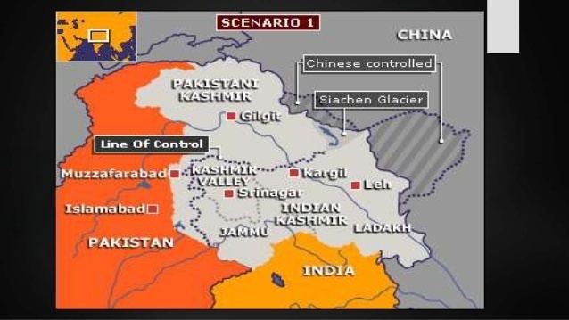
The Indian army controls all of the 76 kilometres (47 mi) long Siachen Glacier and all of its tributary glaciers, as well as the three main passes of the Saltoro Ridge immediately west of the glacier—Sia La, Bilafond La, and Gyong La—thus holding onto the tactical advantage of high ground. "Indians have been able to hold on to the tactical advantage of the high ground..... Most of India's many outposts are west of the Siachen Glacier along the Saltoro Range. In an academic study with detailed maps and satellite images, co-authored by brigadiers from both the Pakistani and Indian military, pages 16 and 27: "Since 1984, the Indian army has been in physical possession of most of the heights on the Saltoro Range west of the Siachen Glacier, while the Pakistan army has held posts at lower elevations of western slopes of the spurs emanating from the Saltoro ridgeline. The Indian army has secured its position on the ridgeline."
The Pakistanis control the glacial valley just five kilometers southwest of Gyong La. The Pakistanis have been unable get up to the crest of the Saltoro Ridge, while the Indians cannot come down and abandon their strategic high posts.
The line between where Indian and Pakistani troops are presently holding onto their respective posts is being increasingly referred to as the Actual Ground Position Line (AGPL).
Severe conditions
A cease-fire went into effect in 2003. Even before then, every year more soldiers were killed because of severe weather than enemy firing. The two sides by 2003 had lost an estimated 2,000 personnel primarily due to frostbite, avalanches and other complications. Together, the nations have about 150 manned outposts along the glacier, with some 3,000 troops each. Official figures for maintaining these outposts are put at ~$300 and ~$200 million for India and Pakistan respectively. India built the world's highest helipad on the glacier at Point Sonam, 21,000 feet (6,400 m) above the sea level, to supply its troops. The problems of reinforcing or evacuating the high-altitude ridgeline have led to India's development of the Dhruv Mk III helicopter, powered by the Shakti engine, which was flight-tested to lift and land personnel and stores from the Sonam post, the highest permanently manned post in the world. India also installed the world's highest telephone booth on the glacier.
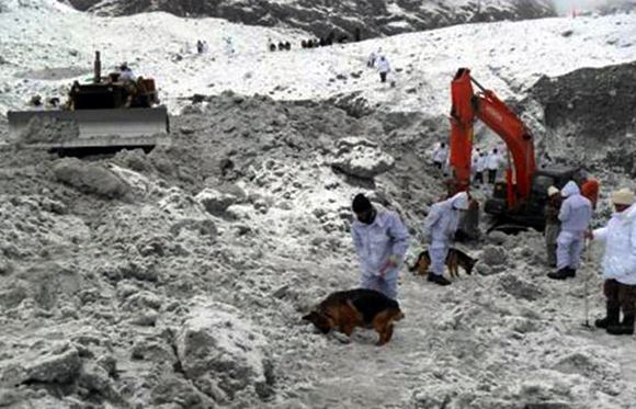
According to some estimates, 97% of the casualties in Siachen have been due to weather and altitude, rather than actual fighting. In 2012, an avalanche hit Pakistan's Gayari military base, killing 129 soldiers and 11 civilians.
Kargil War
One of the factors behind the Kargil War in 1999 when Pakistan sent infiltrators to occupy vacated Indian posts across the Line of Control was their belief that India would be forced to withdraw from Siachen in exchange of a Pakistani withdrawal from Kargil. After the Kargil War, India decided to maintain its military outposts on the glacier, wary of further Pakistani incursions into Kashmir if they vacate from the Siachen Glacier posts.
Visits
During her tenure as Prime Minister of Pakistan, Ms Benazir Bhutto, visited the area west of Gyong La, making her the first premier from either side to get to the Siachen region. On June 12, 2005, Prime Minister Manmohan Singh became the first Indian Prime Minister to visit the area, calling for a peaceful resolution of the problem. In 2007, the President of India, Abdul Kalam became the first head of state to visit the area. Indian Prime Minister Narendra Modi visited Siachen on 23 October 2014 to celebrate Diwali with the troops and boost their morale.
The Chief of Staff of the US Army, General George Casey on October 17, 2008 visited the Siachen Glacier along with Indian Army Chief, General Deepak Kapoor. The US General visited for the purpose of "developing concepts and medical aspects of fighting in severe cold conditions and high altitude".
Since September 2007, India has welcomed mountaineering and trekking expeditions to the forbidding glacial heights. The expeditions have been meant to show the international audience that Indian troops hold "almost all dominating heights" on the important Saltoro Ridge west of Siachen Glacier, and to show that Pakistani troops are not within 15 miles (24 km) of the 43.5-mile (70 km) Siachen Glacier.
Artistic depiction
The Siachen glacier and its conflict was depicted in a 48-page comic book, Siachen: The cold war, released in August 2012. Later its sequel, Battlefield Siachen, was released in January 2013.
List of post-ceasefire avalanches and landslides
On February 11, 2010, an avalanche struck an Indian army post in the Southern Glacier, killing one soldier. A base camp was also struck, that killed two Ladakh scouts. The same day, a single avalanche hit a Pakistani military camp in Bevan sector, killing 8 soldiers.
In 2011, 24 Indian soldiers died on the Siachen glacier from the climate and accidents. On July 22, two Indian officers burned to death when a fire caught on their shelter.
2012-2014
In the early morning of 7 April 2012, an avalanche hit a Pakistani military headquarters in the Gayari Sector, burying 129 soldiers of the 6th Northern Light Infantry battalion and 11 civilian contractors. In the aftermath of the disaster, Pakistan's army chief General Ashfaq Parvez Kayani suggested India and Pakistan should withdraw all troops from the contested glacier.
On May 29, two Pakistani soldiers were killed in a landslide in the Chorbat Sector.
On 12 December, an avalanche killed 6 Indian soldiers in the Sub Sector Hanif in Turtuk area, when troops of the 1st Assam regiment were moving between posts. In 2012, a total of 12 Indian soldiers died of hostile weather conditions.
In 2013, 10 Indian soldiers died due to weather conditions.
2015
On 14 November 2015, an Indian captain from the Third Ladakh scouts died in an avalanche in the Southern Glacier while 15 others were rescued.
2016
On 4 January 2016, four Indian soldiers of the Ladakh Scouts, were killed in an avalanche on the Southern Glacier while on patrol duty in Nobra Valley.
On the morning of 3 February 2016, ten Indian soldiers including one Junior commissioned officer of the 6th Madras battalion were buried under the snow when a massive avalanche struck their post in the Northern Glacier at a height of 19,600 feet, on the Actual Ground Position Line. Pakistani officials offered their help in search and rescue operations 30 hours after the incident, although it was declined by Indian military authorities. During the rescue operations, the Indian army found Lance Naik Hanumanthappa alive, though in a critical condition, after being buried under 25 feet snow for 6 days. He was taken to Army Research and Referral Hospital in Delhi. His condition became critical later on due to multiple organ failure and lack of oxygen to brain and he died 11 February 2016.
On 27 February, a civilian porter working with the Indian army in the Northern Glacier, fell to his death in a 130-foot crevasse.
On 17 March, two Indian soldiers from the Chennai-21 regiment were killed, and bodies recovered in 12-feet deep ice.
On 25 March, two Indian jawans died after they were buried in an avalanche in the Turtuk sector while on patrol.
On 1 April, Indian General Dalbir Singh and General D. S. Hooda of the Northern Command visited the Siachen glacier in order to boost morale after 17 of its soldiers died in 2016.