
Range Karakoram | Elevation 5,540 m | |
 | ||
Traversed by Robert Shaw (1868); Francis E. Younghusband (1889); Theodore Jr. and Kermit Roosevelt (1926). Similar Saltoro Kangri, Sasser Pass, Kilik Pass, Teram Kangri, Batura Sar | ||
Karakoram highway the border of china and pakistan
The Karakoram Pass (Hindi: क़राक़रम दर्रा; Chinese: 喀喇昆仑山口) is a 5,540 m or 18,176 ft mountain pass between India and China in the Karakoram Range. It is the highest pass on the ancient caravan route between Leh in Ladakh and Yarkand in the Tarim Basin. 'Karakoram' literally means 'Black Gravel' in Turkic.
Contents
- Karakoram highway the border of china and pakistan
- Map of Karakoram Pass Pishan Hotan China
- Geopolitical issues
- References
Map of Karakoram Pass, Pishan, Hotan, China
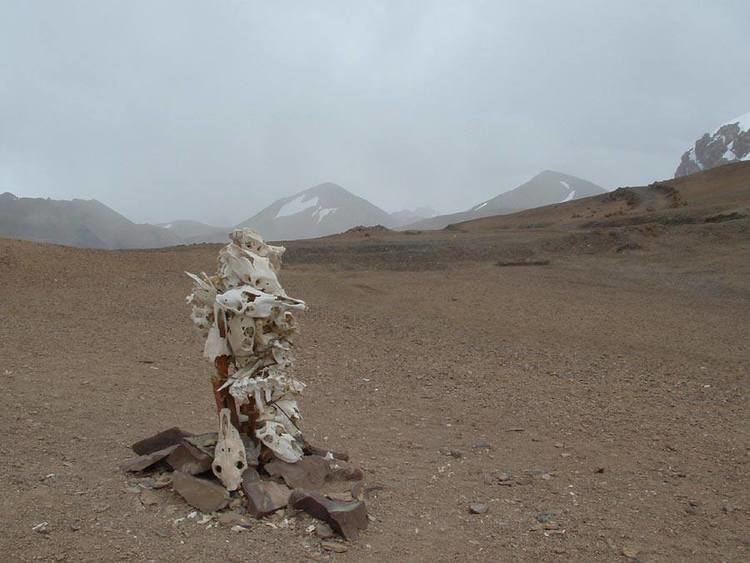
Historically, the high altitude of the pass and the lack of fodder were responsible for the deaths of countless pack animals while the route was notorious for the trail of bones strewn along the way. There is an almost total absence of vegetation on the approaches to the pass.
Travelling south from the pass involved three days' march across the barren Depsang Plains at about 5,300 m (17,400 ft). To the north, the country was somewhat less desolate and involved travellers crossing the relatively easy and lower Suget Dawan (or Suget Pass) before reaching the lush grazing grounds around Shahidullah or Xaidulla in the upper valley of the Karakash River.
The pass is in a saddle between two mountains and about 45 metres (148 ft) wide. There is no vegetation or icecap and it is generally free of snow due to the winds. Temperatures are low, there are often very high winds, blizzards are frequent, and the extreme altitude often took its toll. In spite of all this, the Karakoram Pass was considered a relatively easy pass due to the gradual ascent on both sides, and lack of summer snow and ice much of the year. Consequently, the pass was open throughout most of the year. There is no motorable road across the pass, and the pass currently remains closed to all traffic.
Geopolitical issues
The Karakoram pass falls on the boundary of territory controlled by India (Jammu and Kashmir region) and China (Xinjiang Autonomous Region).
It also plays a major geographic role in the dispute between Pakistan and India over control of the Siachen Glacier area immediately to the west of the pass. This situation arose from the Simla Agreement, signed in 1972 between India and Pakistan, when the treaty failed to specify the last 100 km (60 mi) or so of the cease-fire line from the end of the Line of Control to the border with China.
A potential China-India-Pakistan tripoint at Karakoram Pass is referenced in a 1963 boundary treaty between China and Pakistan concerning the Trans-Karakoram Tract, but India was not party to that treaty nor any tripoint agreement. The current de facto tripoint is about 100 km west of the pass near Indira Col in the Siachen Muztagh, where the Actual Ground Position Line between Indian and Pakistani forces meets the border with China.