
Nearest city Cody, WY Phone +1 307-527-6241 Number of visitors 646,000 | Governing body U.S. Forest Service Area 9,983 km² Established March 3, 1891 | |
 | ||
Hours Open today · Open 24 hoursSundayOpen 24 hoursMondayOpen 24 hoursTuesdayOpen 24 hoursWednesdayOpen 24 hoursThursdayOpen 24 hoursFridayOpen 24 hoursSaturdayOpen 24 hoursSuggest an edit Profiles | ||
Shoshone national forest
Shoshone National Forest (/ʃoʊˈʃoʊniː/ shoh-SHOH-nee) is the first federally protected National Forest in the United States and covers nearly 2,500,000 acres (1,000,000 ha) in the state of Wyoming. Originally a part of the Yellowstone Timberland Reserve, the forest is managed by the United States Forest Service and was created by an act of Congress and signed into law by U.S. President Benjamin Harrison in 1891. Shoshone National Forest is one of the first nationally protected land areas anywhere. Native Americans have lived in the region for at least 10,000 years, and when the region was first explored by European adventurers, forestlands were occupied by several different tribes. Never heavily settled or exploited, the forest has retained most of its wildness. Shoshone National Forest is a part of the Greater Yellowstone Ecosystem, a nearly unbroken expanse of federally protected lands encompassing an estimated 20,000,000 acres (8,100,000 ha).
Contents
- Shoshone national forest
- The shoshone river shoshone national forest cody wyoming 4k ultra hd sony fdr ax 33
- Human history
- Forest management
- Geography and geology
- Glaciology
- Climate
- Recreation
- Scenic roads
- Popular culture
- References
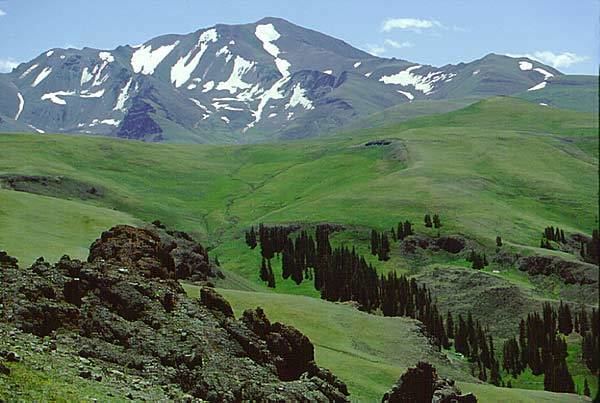
The Absaroka and Beartooth Mountains are partly in the northern section of the forest. The Wind River Range is in the southern portion and contains Gannett Peak, the tallest mountain in Wyoming. Yellowstone National Park forms part of the boundary to the west; south of Yellowstone, the Continental Divide separates the forest from its neighbor Bridger-Teton National Forest to the west. The eastern boundary includes privately owned property, lands managed by the U.S. Bureau of Land Management and the Wind River Indian Reservation, which belongs to the Shoshone and Arapahoe Indians. Custer National Forest along the Montana border is on the northern frontier. The Oregon Trail, the 19th century covered wagon route, passes just south of the forest, where broad and gentle South Pass allowed the migrants to bypass the rugged mountains to the north.
Shoshone National Forest has virtually all the original animal and plant species that were there when white explorers such as John Colter and Jim Bridger first visited the region. The forest is home to the Grizzly bear, cougar, moose, tens of thousands of elk as well as the largest herd of bighorn sheep in the U.S. The streams in the forest are considered to have some of the best game species fishing opportunities in the U.S. including Yellowstone cutthroat trout. More than 1,300 miles of hiking trails, 32 campgrounds and adjacent forests and parklands provide numerous recreational opportunities. There are four wilderness areas within the forest, protecting more than half of the managed land area from development. From sagebrush plains through dense spruce and fir forest to craggy mountain peaks, Shoshone National Forest has a rich biodiversity rarely matched in any protected area.
The shoshone river shoshone national forest cody wyoming 4k ultra hd sony fdr ax 33
Human history
Shoshone National Forest is named after the Shoshone Indians, who, along with other Native American groups such as the Lakota, Crow and Northern Cheyenne, were the major tribes encountered by the first white explorers into the region. Archeological evidence suggests that the presence of Indian tribes in the area extends back at least 10,000 years. The forest provided an abundance of game meat, wood products, and shelter during the winter months from the more exposed high plains to the east. Portions of the more mountainous regions were frequented by the Shoshone and Sioux for spiritual healing and vision quests. By the early 1840s, Washakie had become the leader of the easternmost branch of the Shoshone Indians. At the Fort Bridger Treaty Council of 1868 Washakie negotiated with the U.S. Government for 44,000,000 acres (18,000,000 ha)) to be preserved as tribal lands. Subsequent amendments to the treaty reduced the actual acreage to approximately 2,000,000 acres (810,000 ha) and is known today as the Wind River Indian Reservation.
In 1957, Mummy Cave was rediscovered by a local resident on the north side of the North Fork Shoshone River, adjacent to U.S. Routes 14/16/20, 15 mi (24 km) east of Yellowstone National Park. Subsequent archeological excavations in the 1960s produced evidence that the cave had been occupied for over 9,000 years. The oldest deposits in the cave yielded prismatic stone blades and other artifacts created by paleoindians and the surrounding soils were radiocarbon dated to 7,300 BC. The evidence indicates the cave was occupied from at least 7280 BC to 1580 AD. Besides projectile points, the cave also produced well preserved feathers, animal hides and other usually perishable materials. Additionally, the mummified remains of an individual buried inside a rock cairn were unearthed, which were dated to 800 AD. Considered one of the finest paleoindian archeological assemblages in the Rocky Mountain region, the site was placed on the National Register of Historic Places list in 1981.
In the early 19th century, the forest was visited by mountain men and explorers such as John Colter and Jim Bridger. Colter is the first white man known to have visited both the Yellowstone region and the forest, which he did between 1807 and 1808. Having been an original member of the Lewis and Clark Expedition, Colter requested permission from Meriwether Lewis to leave the expedition after it had finished crossing the Rocky Mountains during their return journey from the Pacific Ocean. Colter teamed up with two unaffiliated explorers the expedition had encountered, but soon thereafter decided to explore regions south of where his new partners wished to venture. Traveling first into the northeastern region of what is today Yellowstone National Park, Colter then explored the Absaroka Mountains, crossing over Togwotee Pass and entering the valley known today as Jackson Hole. Colter survived a grizzly bear attack and a pursuit by a band of Blackfeet Indians who had taken his horse. The explorer later provided William Clark, who had been his commander on the Lewis and Clark Expedition, with previously unknown information on the regions he had explored, which Clark published in 1814.
Travels by fur trappers and adventurers, such as Manuel Lisa and Jim Bridger from 1807 to 1840, completed the exploration of the region. With the decline of the fur trade in the late 1840s and much of the prized beaver long since made scarce by over-trapping, few white explorers entered the forest over the next few decades. The first federally financed expedition which passed through portions of Shoshone National Forest was the Raynolds Expedition of 1860, led by topographical engineer Captain William F. Raynolds. The expedition included geologist and naturalist Ferdinand Vandeveer Hayden and was guided by mountain man Jim Bridger. Though the Raynolds Expedition was focused on exploration of the Yellowstone region, several efforts to enter what later became Yellowstone National Park were impeded by heavy snows across the mountain passes such as Two Ocean Pass. The expedition finally crossed the northern Wind River Range at a pass they named Union Pass and entered Jackson Hole valley to the south of Yellowstone. Hayden led another expedition through the region in 1871. Hayden was primarily interested in documenting the Yellowstone country west of the forest, but his expedition also established that the forest was a prime resource that merited protection. Travels in the forest in the 1880s by later U.S. President Theodore Roosevelt, who was also a strong advocate of land conservation, as well as by General Philip Sheridan, provided the impetus that subsequently established the Yellowstone Timberland Reserve in 1891, creating the first national forest in the U.S.
In 1902, President Roosevelt first greatly expanded the reserve and then divided the reserve into four separate units, with Shoshone being the largest. Upon the creation of the U.S. Forest Service in 1905, the reserve was designated a National Forest, but the current wording and title were formulated forty years later in 1945. A remnant of the earliest years of the forest management is the Wapiti Ranger Station which is located west of Cody, Wyoming. The station was built in 1903 and is the oldest surviving ranger station in any national forest, and is now designated a National Historic Landmark.
Prior to the establishment of the Wind River Indian Reservation, the U.S. Cavalry constructed Fort Brown on the reservation lands, which was subsequently renamed Fort Washakie. During the late 19th century, the fort was staffed by African-American members of the U.S. Cavalry, better known as the Buffalo Soldiers, including the second African-American graduated from the United States Military Academy, John Hanks Alexander. Chief Washakie is buried at the fort, which is located immediately east of the forest boundary. Rumor has it that Sacajawea, the Shoshone Indian who provided invaluable assistance to Meriwether Lewis and William Clark during the Lewis and Clark Expedition, is also buried here, but it is now considered that this is unlikely and that her actual burial place was Fort Lisa in North Dakota.
During the last decade of the 19th century, minerals such as gold were mined with limited success. The last mine was abandoned in 1907, but panning for gold is still allowed in many areas of the forest, and in most circumstances no permit is required. After the end of the mining era, numerous camps were established by the Civilian Conservation Corps to help combat unemployment during the Great Depression of the 1930s. The camps housed groups of unemployed men who were paid by the federal government to build roads, hiking trails, and campgrounds for future travelers to the Yellowstone region. Visitation to national forests like Shoshone increased dramatically after World War II with the advent of better roads and accessibility to the region.
Forest management
Shoshone National Forest is managed by the U.S. Forest Service, an agency within the U.S. Department of Agriculture. The forest is separated into five districts and from 2008 and 2012 had an average staff of 165 employees and an annual operating budget of $17,500,000. The headquarters and a visitor center are in Cody, Wyoming and a smaller information center is in Lander, Wyoming. There are local ranger district offices in Cody, Dubois and Lander.
Shoshone National Forest practices conservation of resources, which ensures a sustainable flow of some raw materials from the forest, such as lumber for construction purposes and wood pulp for paper products. The forest averages an annual harvest of 4.5 million board-feet of timber for the purposes of commercial log home construction and another 2.5 million board-feet of wood collection from dead and down trees that are used for firewood and poles. Additionally, low-scale mineral extraction and oil and gas exploration and recovery are also conducted, though in Shoshone National Forest this has become less common due to a consensus to protect the natural surroundings. Only 8,570 acres (3,470 ha) of oil and gas leases were filed as of 2013. More common than logging and mining are the lease options that are offered to ranchers to allow them to graze cattle and sheep. The U.S. Forest Service provides guidelines and enforces environmental regulations to ensure that resources are not overexploited and that necessary commodities are available for future generations, though conservation groups have voiced concerns over the management practices of the leasing program and especially cattle overgrazing problems. Leases for sheep grazing have declined considerably since the 1940s while cattle grazing has remained relatively constant.
Geography and geology
Shoshone National Forest borders Yellowstone National Park and Bridger-Teton National Forest to the west. The Continental Divide demarks the boundary between Shoshone and Bridger-Teton National Forests. Along the Montana border, Shoshone National Forest borders Custer National Forest to the north. Private property, property belonging to the state of Wyoming and lands administered by the Bureau of Land Management form the eastern boundaries. Lastly, the Wind River Indian Reservation also borders on the east, and bisects a smaller southern section which includes the Popo Agie Wilderness and the Washakie Ranger District.
The altitude in the forest ranges from 4,600 feet (1,400 m) near Cody, Wyoming, to 13,804 ft (4,207 m) at the top of Gannett Peak, an elevation gain of over 9,200 ft (2,800 m). Of the three major mountain ranges found in the forest, they are geologically distinct from each other. All of the mountains are a part of the Rocky Mountains. In the northern and central portions of the forest lie the Absaroka Mountains which were named after the Crow Indian tribe. The majority of the Absaroka Mountains are contained within the forest, with the highest peak being Francs Peak at 13,158 ft (4,011 m). The peaks of the Absaroka are basaltic in origin, having been the result of volcanic activity estimated to have occurred 50 million years ago during the Eocene epoch. The rocks are composed of mostly andesite and breccias deposited for millions of years during volcanic events and are atop more ancient sedimentary rocks that are considered to have economically viable mineral wealth. Gold was mined from the slopes of Francs Peak between the years 1890 and 1915, and the small ghost town of Kirwin remains as a legacy of that period. Major tributaries of the Bighorn River, such as the Shoshone and Greybull Rivers, originate in the Absaroka Mountains. Important passes through the Absarokas include Sylvan Pass, which leads to the eastern entrance of Yellowstone National Park; and Togwotee Pass, which provides access to Jackson Hole and Grand Teton National Park.
In the far north of Shoshone National Forest a small portion of the Beartooth Mountains are located north of the Clarks Fork of the Yellowstone River. The Beartooths are composed of Precambrian granitic rocks that are amongst the oldest found on Earth. Although often considered a part of the Absaroka Mountains, the Beartooths are distinct in appearance and geologic history. Uplifted approximately 70 million years ago during the Laramide orogeny, the Beartooths consist of vast windswept plateaus and rugged peaks with sheer cliff faces. The Beartooth Highway (U.S. Highway 212) crosses 10,974-foot (3,340 m) Beartooth Pass, and from there descends to the northeast entrance to Yellowstone National Park.
The Wind River Range is in the southern portion of the forest and is composed primarily of Precambrian granitic rock. Gannett Peak, the tallest mountain in Wyoming, is in the northern part of the range. Altogether eight peaks exceed 13,500 ft (4,100 m) and 119 rise at least 12,000 ft (3,700 m) above sea level. Fremont Peak, the second highest peak in the range, was originally believed to be the tallest mountain in the Rocky Mountains due to its prominence when viewed from the Oregon Trail by early pioneers. The Wind River Range is popular with mountain climbers because of its solid rock and variety of routes. The Cirque of the Towers in the Popo Agie Wilderness is one of the more popular climbing and hiking destinations, and an estimated 200 different climbing routes are located within the peaks that surround the cirque.
There are over 500 lakes in the forest, and 1,000 mi (1,600 km) of streams and rivers. The Clarks Fork of the Yellowstone River is federally designated as a Wild and Scenic River for 22 mi (35 km) through the forest, with cliffs towering up to 2,000 ft (610 m) as the river winds through a gorge. The forest is on the eastern slopes of the Continental Divide, and the rivers flow into the Atlantic Ocean basin.
Glaciology
According to the U.S. Forest Service, Shoshone National Forest has the greatest number of glaciers of any National Forest in the Rocky Mountains. The forest recreation guide lists 16 named and 140 unnamed glaciers within the forest, all in the Wind River Range. Forty-four of these glaciers are in the Fitzpatrick Wilderness, centered around the highest mountain peaks. However, the state water board for Wyoming lists only 63 glaciers for the entire Wind River Range, which includes glaciers in adjacent Bridger-Teton National Forest. Researchers claim that for most of the period that glaciers have been known to exist in the forest, that they have been in a state of general retreat, with glacial mass losses of as much as 25 percent between the years 1985 and 2009.
Reversing the growth of mid-latitude glaciers that occurred during the Little Ice Age (1350–1850), there has been a worldwide reduction of mountain glacial ice since, with some regions losing as much as 50 percent of their peak ice cover. This can be correlated by examining photographic evidence of glaciers taken over time even with an absence of other means of documentation. The behavior of the glaciers of Shoshone National Forest is consistent with this pattern. In one study of Dinwoody and Gannett Glaciers, during the period from 1958 to 1983, the thickness of these glaciers was reduced 77 and 61 ft (23 and 19 m), respectively.
Gannett Glacier, on the northeast slope of Gannett Peak, is the largest single glacier in the U.S. Rocky Mountains. It has reportedly lost over 50 percent of its volume since 1920 with 25 percent of that occurring between the years 1980–1999. Upper Fremont Glacier has been studied more than any other glacier in the Wind River Range. Scientist have obtained ice cores from the Upper Fremont Glacier and found that there have been measurable changes in the atmosphere over the past several hundred years. The Upper Fremont Glacier and the Quelccaya Ice Cap in the Andes of South America both show nearly identical atmospheric records, which indicate a global linkage of atmospheric conditions over time.
The small glaciers in the forest are less able to resist melting than the great ice sheets of Greenland and Antarctica. Once a glacier begins retreating, it may fall into disequilibrium and be unable to find mass balance (accumulation versus melting rate) at any size. Without a favorable climate change, it will continue to retreat until it disappears. Loss of glacial ice already reduces the summer glacial runoff that supplies water to streams and lakes and provides a cold-water source vital to certain fish and plant species. This, in turn, may have a significant impact on the forest ecosystem over time.
Climate
Wyoming is an arid state, averaging 12.68 inches (32.2 cm) of precipitation annually. However, Shoshone National Forest is located in and near some of the largest mountain ranges in the state, and consequently receives anywhere between 15 and 70 in (380 and 1,780 mm) annually. Higher elevations in the forest not only get more precipitation than lower elevations, but also have lower overall temperatures, with summertime highs around 60 °F (16 °C) and lows near 35 °F (2 °C) while lower elevations may be 20 °F (−7 °C) or warmer on average. Humidity levels throughout the forest are low, especially at higher altitudes. In the middle of the forest at the Wapiti Ranger Station, which is 30 mi (48 km) west of the forest headquarters in Cody, Wyoming, January high and low temperatures are 35.8 and 13.2 °F (2.1 and −10.4 °C), while the July highs and lows are 81.4 and 49.1 °F (27.4 and 9.5 °C). The annual precipitation at Wapiti is 10.37 in (263 mm).
Most of the precipitation falls in the winter and early spring, while summer is punctuated with widely scattered thunderstorms. The autumn is usually cool and dry. Due to the altitude and dryness of the atmosphere, vigorous radiative cooling occurs throughout the year, and exceptional daily temperature variances are not uncommon. Consequently, the nights range from very cool in the summer to extremely cold in the winter; therefore, visitors should always remember to bring along at least a jacket, even during the summer. Records indicate that the highest temperature ever recorded in the forest was 100 °F (38 °C) in 1978, while the coldest was −49 °F (−45 °C) in 1972.
Recreation
Shoshone National Forest receives an average of over half a million visitors a year. Two visitor centers provide orientation, books, maps, and interpretive displays. One visitor center is at the Wapiti Wayside on the Buffalo Bill Cody Scenic Byway, west of Cody, Wyoming and adjacent to the historic Wapiti Ranger Station while the other visitor center is to the south in Lander, Wyoming. There are 30 vehicle access campgrounds in the forest, with up to 54 individual sites per campground. Approximately half of these campgrounds provide running water and restroom facilities and also provide for handicapped accessibility. Referred to as "front country" campgrounds, they also permit recreational vehicle access in most cases. All of the campgrounds are on a first come, first served basis although four campgrounds have sites that can be reserved in advance by contacting the National Reservation Service. Due to the presence of grizzly bears, a few of the campgrounds require what is referred to as "hard-sided" camping only, and tent camping is not permitted.
For some visitors the greater solitude of the backcountry requires using hiking trails to backpacking or horseback riding into more remote destinations such as Blackwater Natural Bridge which can be accessed from Blackwater Natural Bridge trailhead. There are dozens of trails which total over 1,600 mi (2,600 km) located throughout the forest. Many of the trailheads can be accessed at campgrounds, with shorter day hikes available as well. The Continental Divide Trail has a 20-mile (32 km) section which passes through the forest and crosses the Continental Divide at Sheridan Pass. There is also the Nez Perce National Historic Trail and the Beartooth Loop National Recreation Trail, both of which are in the northern regions of the forest. Some remote areas can also be accessed by horseback. Trailheads usually provide enough room for horse and pack animal trailers plus personal vehicles. Along forest access roads, all-terrain vehicles (ATV) are allowed, but since wilderness areas do not permit access by way of motorized transport, those who wish to visit such areas usually do so either by hiking in or on horseback.
Hunting and fishing are popular recreational activities permitted throughout the forest. Many of the streams and rivers are considered to be "Blue Ribbon Trout Streams". Though many streams and lakes have excellent opportunities to catch various species of trout, the north and south forks of the Shoshone River, the Greybull River and the Clark's Fork of the Yellowstone, the only federally designated Wild and Scenic River in Wyoming, are a few of the better locations to reign in a trophy level Rainbow or Yellowstone cutthroat trout. 1,000 miles (1,600 km) of streams and a hundred lakes that can be legally fished from provide plenty of elbow room during even the most crowded of fishing seasons. Hunting and fishing licenses are sponsored by the state of Wyoming and are available through the Wyoming Game and Fish Department.
The southern section of the forest in the Wind River Range is the primary destination for mountain climbers. Nine of the highest 10 peaks in Wyoming are here, and the mountains are primarily of granitic rock with countless cliffs and sheer rock walls. The Cirque of the Towers is particularly popular as it has numerous peaks within a relatively short distance of each other. Two particular climbs on the peaks in the cirque are considered amongst the finest climbing adventures available in the U.S. The Absaroka Range also attracts climbers but not of a technical nature since the rocks are not considered solid enough for good anchoring points. For the tallest peaks in the Wind River Range, the entire summiting effort will take even experienced climbers many days due to the inaccessibility of the region and complexity of the climbing effort.
Winter activities include cross-country skiing and snowmobiling, with 48 mi (77 km) of groomed trails for cross-country skiing and over 300 mi (480 km) for use by snowmobilers. The region around Togwotee Pass allows snowmobilers easy access from paved roads and has snow depths of between 6 to 10 ft (1.8 to 3.0 m) annually at elevations of 8,000 to 10,000 ft (2,400 to 3,000 m), which equates to a long season for winter activities.
Scenic roads
Shoshone National Forest forms the eastern boundary of Yellowstone National Park and the northeastern and eastern entrances to the park are both accessed by way of designated scenic roadways. A federally designated National Scenic Byways All-American Road, the Beartooth Highway (U.S. Highway 212), weaves through the forest and serves as the northeastern entranceway to Yellowstone National Park. Chief Joseph Scenic Byway (Wyoming Highway 296) connects Cody, Wyoming with the Beartooth Highway and follows the old trail in which Chief Joseph and the Nez Perce tribe attempted to flee the U.S. Cavalry in 1877. South of there, Buffalo Bill Cody Scenic Byway (US 14/16/20) heads west from Cody, Wyoming, passes through the forest and crosses Sylvan Pass as it enters Yellowstone. Lastly, the Wyoming Centennial Scenic Byway (US 26/287) heads northwest from Dubois, Wyoming, over Togwotee Pass and enters Jackson Hole and Grand Teton National Park. Though the Beartooth Highway is the only one of these four roads that is a National Scenic Byway, all four of them have been designated Wyoming State Scenic Byways by the state of Wyoming.
Popular culture
Shoshone National Forest was the setting of the 2016 first person adventure video game, Firewatch.