
Traversed by Prehistoric Added to NRHP 4 April 1969 | Elevation 2,808 m | |
 | ||
Topo map USGS Fish Creek Park (WY) Similar | ||
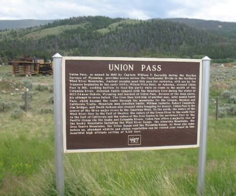
Union Pass is a high mountain pass in the Wind River Range situated in Fremont County of western Wyoming in the United States. The pass is located on the Continental Divide between the Gros Ventre mountains on the west and the Wind River Range on the east. A triple divide exists nearby, where water may flow to the Mississippi River, Columbia River, or Colorado River. The pass was historically used by Native Americans and early mountain men including the Astor Expedition in 1811 on its way west. On the return trip, fearing hostile Indian activity near Union Pass, the Astorians chose a southern route and discovered South Pass.
Map of Union Pass, Wyoming 82513, USA
The pass was named by U.S. Army Captain William F. Raynolds in 1860. Raynolds was in charge of the Raynolds Expedition which was exploring the Yellowstone region immediately prior to the Civil War. After mountain man and guide Jim Bridger led the expedition over the pass, Raynolds gave the pass its current name.
The Wyoming state highway map lists the following trails of the Union Pass area:
An unimproved dirt road crosses the pass, connecting U.S. Route 287 near Dubois to U.S. Route 189 in Pinedale.