
Topo map USGS Francs Peak Elevation 4,009 m | Easiest route Hike Prominence 1,236 m | |
 | ||
Similar Wind River Peak, Trout Peak, Atna Peaks, South River Peak, Antora Peak | ||
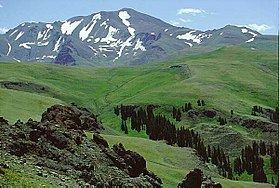
Francs Peak (13,158 feet (4,011 m)) is the highest point in the Absaroka Range which extends from north central Wyoming into south central Montana, in the United States. It is located in the Washakie Wilderness of Shoshone National Forest, and the peak is also the highest point in Park County, Wyoming, which includes much of Yellowstone National Park. It was named after Otto Franc, a cattle baron and homesteader in the Big Horn Basin.
Map of Francs Peak, Wyoming 82433, USA
References
Francs Peak Wikipedia(Text) CC BY-SA