
Elevation 2,944 m | ||
 | ||
Traversed by U.S. Highway 287/U.S. Highway 26 Road U.S. Route 287, U.S. Route 26 Similar Grand Teton National, Teton Pass, Bridger‑Teton National Forest, Rocky Mountains, Snow King Mountain | ||
Togwotee Pass (pronounced toe'-ga-tee) (el. 9658 ft/2944 m) is a mountain pass located on the Great continental divide in the Absaroka Mountains of the United States, between the towns of Dubois and Moran Junction, Wyoming in the Jackson Hole valley.
Map of Togwotee Pass, Wyoming 82513, USA
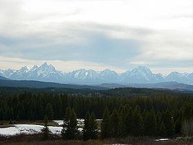
U.S. Highway 287 and U.S. Highway 26 cross the pass, which is located approximately 25 miles (40 km) east of Moran Junction. The pass provides the most direct access to Grand Teton National Park from eastern Wyoming. Located between Two Oceans Mountain and Brecca Peak, sweeping vistas of the Teton Range are visible from the western slopes of the pass.
The pass is located in the Bridger-Teton National Forest and adjacent to Shoshone National Forest. The pass receives heavy winter snowfall and is a top destination for snowmobiling and cross-country skiing. Snowfall at the pass often exceeds 25 feet (760 cm) (reports of over 50 feet (15 m) of snow are also known) in any given winter and the road can be shut down for days at a time during blizzards. The Continental Divide Snowmobile Trail passes through the immediate area.
The pass is named for Togwotee, a subchief under Chief Washakie of the Sheepeater tribe, a branch of the Shoshones. Togwotee led a U.S. government exploratory expedition over this pass in 1873.
A ski run (mainly a traverse) at the Jackson Hole ski resort is also named Togwotee Pass. [1]