
Population 233 (2011 est) Founded 1921 | Established 1921 Area 1,164 km² Mayor Eileen O'Connell | |
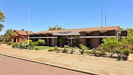 | ||
The Shire of Nungarin is a local government area in the Wheatbelt region of Western Australia, and, with a population of 264 as at the 2001 census, is one of the nation's smallest. It is located about 40 kilometres (25 mi) north of Merredin and about 300 kilometres (186 mi) east of the state capital, Perth. The Shire covers an area of 1,164 square kilometres (449 sq mi), and its seat of government is the town of Nungarin.
Contents
Map of Nungarin, WA 6490, Australia
History
Initially, Nungarin was governed by the Kellerberrin Road Board. In 1911, responsibility for the area was transferred to the Merredin Road Board. In 1921, the Nungarin Road District was gazetted, which extended north into the present Mount Marshall Shire. In 1933 it lost over three-quarters of its land area with the formation of Mukinbudin Road District. On 1 July 1961, it became the Shire of Nungarin under the Local Government Act 1960.
Wards
The Shire has been divided into 3 wards. Prior to the elections in May 2003, there were 7 wards.