Suvarna Garge (Editor)

Route nationale 618

Updated on
Edit
Like
Comment
Share on FacebookTweet on TwitterShare on LinkedInShare on Reddit
Length
  
522 km

Route nationale 618

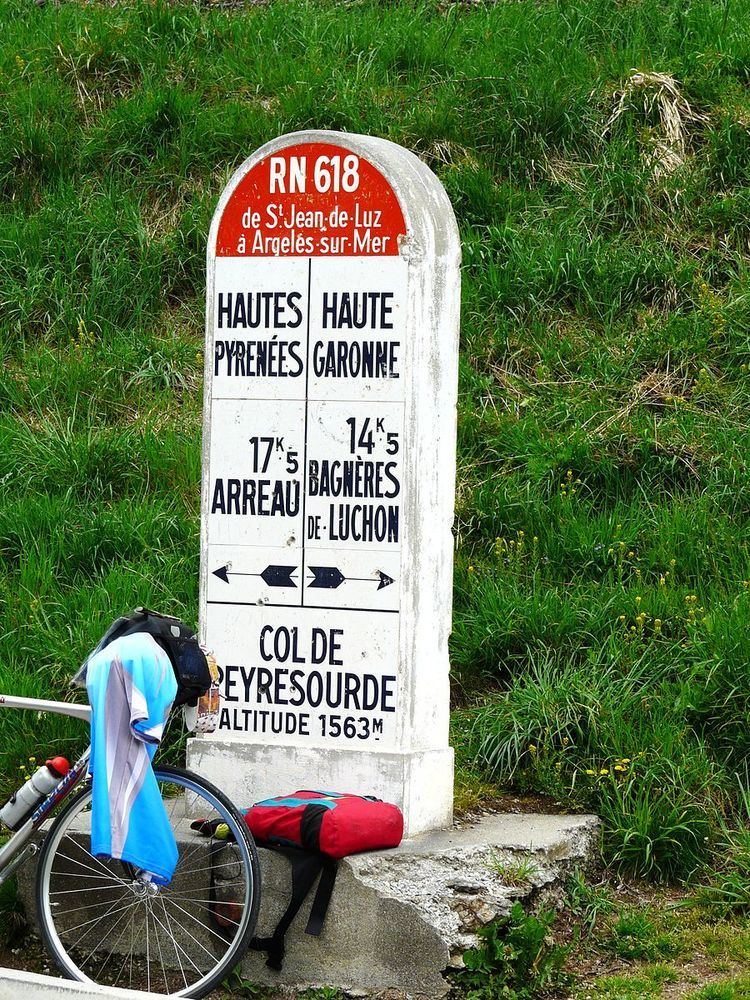
Route nationale 618 or RN 618 was a French national road linking Saint-Jean-de-Luz (on the Atlantic Ocean) to Argelès-sur-Mer (on the Mediterranean). En route it crossed many of the famous passes in the Pyrenees, immortalized by the Tour de France; hence its name was the "Route of the Pyrénées". In 1970, the road was down-graded and is now the RD 918 from Saint-Jean-de-Luz to Arreau and the RD 618 from Arreau to Argelès Plage.

Contents

Map of D918, France

Itinerary

The places named in italic are mountain passes used in the Tour de France.

  • Saint-Jean-de-Luz
  • Cambo-les-Bains
  • Saint-Jean-Pied-de-Port
  • Common with the former RN 133

  • Larceveau-Arros-Cibits
  • Mauléon-Licharre
  • Issor
  • Common with RN 134

  • Lurbe-Saint-Christau
  • Arudy
  • Common with the former RN 134BIS

  • Laruns
  • Col d'Aubisque
  • Col du Soulor
  • Arrens-Marsous
  • Argelès-Gazost
  • Common with the former RN 21

  • Luz-Saint-Sauveur
  • Barèges
  • Col du Tourmalet
  • Sainte-Marie-de-Campan
  • Col d'Aspin
  • Arreau
  • Col de Peyresourde
  • Bagnères-de-Luchon
  • Common with the former RN 125

  • Saint-Mamet
  • Col du Portillon, Spanish frontier.
  • Route interrupted by the Spanish border

  • Chaum
  • Col des Ares
  • Juzet-d'Izaut
  • Col de Portet d'Aspet
  • Saint-Lary
  • Audressein
  • Saint-Girons
  • Massat
  • Col de Port
  • Tarascon-sur-Ariège
  • Common with RN 20

  • Ur
  • Font-Romeu
  • Mont-Louis
  • Common with RN 116

  • Bouleternère
  • Amélie-les-Bains-Palalda
  • Common with the former RN 115

  • Céret
  • Le Boulou
  • Argelès-sur-Mer
  • Argelès Plage
  • References

    Route nationale 618 Wikipedia