
Elevation 1,250 m Traversed by Route nationale 618 | ||
 | ||
Similar Port de Lers, Col de Menté, Port de Pailhères, Col de Latrape, Col de Peyresourde | ||
Col de port ariege
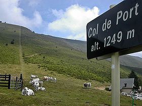
Col de Port (elevation 1,250 m (4,100 ft)) is a mountain pass in the French Pyrenees between Massat and Tarascon-sur-Ariège in the "massif de l'Arize". It links the Couserans and Ariège valleys.
Contents
- Col de port ariege
- Map of Col de Port 09320 Boussenac France
- Col de port
- Details of the climbEdit
- Tour de FranceEdit
- Appearances in the Tour de France since 1947Edit
- References
Map of Col de Port, 09320 Boussenac, France
The pass is used occasionally in the Tour de France and is popular with touring cyclists.
The name of the pass is tautological as Col means pass in French and Port means pass in Occitan.
Col de port
Details of the climbEdit
Starting from the D8/D618 junction, (Tarascon-sur-Ariège) (east) the Col de Port is 17.0 km (10.6 mi) long. Over this distance, the climb is 777 m (2,549 ft) (an average gradient of 4.6%). The steepest section is 9.2%.
Starting from Massat, (west) the Col de Port is 12.8 km (8.0 mi) long. Over this distance, the climb is 601 m (1,972 ft) (an average gradient of 4.7%).
From Massat, the D18 to the south links with the route from Aulus-les-Bains and Vicdessos between the Col d'Agnes (1,570 m (5,150 ft)) and the Port de Lers (1,517 m (4,977 ft)).
Tour de FranceEdit
The Col de Port was first used in the Tour de France in 1910. The first cyclist over the summit was Octave Lapize.
Appearances in the Tour de France (since 1947)Edit
The Tour de France has crossed the summit 10 times since 1947, including on stage 15 of the 2007 tour. The 15th stage was selected for the 2007 L'Étape du Tour, in which amateur and club riders ride over a full stage of the tour.