
Canton Argelès-sur-Mer Local time Tuesday 9:41 PM | Region Occitanie Area 58.67 km² | |
 | ||
Weather 11°C, Wind NW at 50 km/h, 51% Humidity Points of interest Argeles Aventure, Réserve naturelle nationale, Platja del Racó, Plage du Racou, Le Jardin Enchanté | ||
Camping le soleil in argel s sur mer september 2016
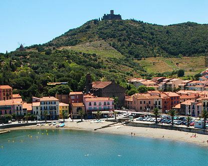
Argelès-sur-Mer (Catalan: Argelers de la Marenda or Argelers) is a commune in the Pyrénées-Orientales department in southern France.
Contents
- Camping le soleil in argel s sur mer september 2016
- Map of 66700 ArgelC3A8s sur Mer France
- Geography
- History
- Sports
- Sites of interest
- Notable people
- References
Map of 66700 Argel%C3%A8s-sur-Mer, France
It is about 25 km from Perpignan.
Geography
Argelès-sur-Mer is located in the canton of Argelès-sur-Mer and in the arrondissement of Céret.
Argelès-sur-Mer is on the Côte Vermeille at the foot of the Albères mountain range, close to the Spanish border. It has the longest beach in the Pyrenées Orientales.
History
During World War II, Argelès-sur-Mer was the location of a concentration camp, where up to 100,000 defeated Spanish Republicans were interned next to a windy beach in abysmal sanitary conditions by the French government after the defeat of the Spanish Republic. The refugees streamed to the camp from the winter of 1938/39 after the collapse of the Catalonian front following the rebel offensive.
Sports
Étoile sportive catalane is the rugby union club of Argelès-sur-Mer.