
Population (2006) 1,419 Area 249 km² | Canton Laruns Time zone CET (UTC+1) Local time Monday 12:53 AM | |
 | ||
Weather 8°C, Wind NW at 10 km/h, 93% Humidity Points of interest Ossau Valley, Lac de Bious‑Artigues, Col du Pourtalet, Lac de Fabrèges, Lac Bersau | ||
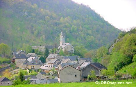
Laruns (Occitan: Laruntz) is a commune in the Pyrénées-Atlantiques department in south-western France.
Contents
Map of 64440 Laruns, France
It is situated at the confluence of two mountain streams, the Gave d'Ossau and its tributary, the Valentin.
Formerly part of the province of Béarn, Laruns is now within the département of Pyrénées-Atlantiques, itself in France's Nouvelle-Aquitaine région. It forms part of the arrondissement of Oloron-Sainte-Marie, and is the chef-lieu of the canton of Laruns.
Geography
Laruns is geographically the third-largest commune in metropolitan France, after Arles and Saintes-Maries-de-la-Mer. It includes a large area of upland, around and between the Gave d'Ossau and its tributaries, stretching as far as the border with Spain at the Col du Pourtalet, 30 km (19 mi) to the south of the village of Laruns.
The principal artery of communications through the commune is the D934 road, which runs south from the town of Pau, 40 km (25 mi) to the north, to the Col du Pourtalet. The D918 road branches off the D934 in Laruns village, and follows the Valentin before crossing the Col d'Aubisque to Argelès-Gazost in the next major valley to the east. There are no direct roads westward from Laruns.
Because of its large geographic size, the Laruns contains several recognisably distinct communities in addition to Laruns itself. These include:
Neighboring communes and municipalities: