
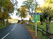
Elevation 797 m Traversed by Route nationale 618 | ||
 | ||
Similar Col de Menté, Port de Balès, Col de Peyresourde, Col du Portillon, Pic du Gar | ||
Descent of col des ares pyrenees
Col des Ares (elevation 797 m (2,615 ft)) is a mountain pass located in Haute-Garonne, between Juzet-d'Izaut and Fronsac, some thirty kilometres north of Bagnères-de-Luchon, and south-west of Aspet.
Contents
- Descent of col des ares pyrenees
- Map of Col des Ares 31160 Cazaunous France
- Col des ares
- Details of the climbs
- Tour de France
- Appearances in Tour de France since 1947
- References
Map of Col des Ares, 31160 Cazaunous, France
Col des ares
Details of the climbs
From Fronsac (west), the ascent is 8.4 km (5.2 mi) long. Over this distance, the climb gains 330 m (1,080 ft) in height at an average of 3.9%.
From La Moulette, near Cazaunous, (east), the climb is 6.7 km (4.2 mi) long climbing 310 m (1,020 ft) at an average of 4.6%. Before reaching Juzet-d'Izaut, the D618 crosses the Col de Buret 599 m (1,965 ft)
Tour de France
The Col des Ares was first used in the Tour de France in 1910 and has appeared frequently since. The leader over the summit in 1910 was Octave Lapize. It was crossed on Stage 17 of the 2012 tour and in 2014 on stage 16.
Appearances in Tour de France (since 1947)
From 1947 to 1952, and in 1957, the climb was not classified.