Neha Patil (Editor)

Route 8 (Uruguay)

Updated on
Edit
Like
Comment
Share on FacebookTweet on TwitterShare on LinkedInShare on Reddit
South end:
  
Montevideo

Length
  
442 km

North end:
  
Aceguá

Route 8 (Uruguay)

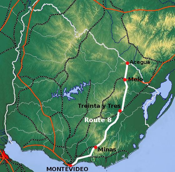
Major cities
  
Montevideo, Aceguá, Uruguay

Route 8 is a national route of Uruguay. In 1975, it was assigned the name Brigadier General Juan Antonio Lavalleja, a national hero of Uruguay. It connects Montevideo with Aceguá in the northeast.

Contents

Map of Ruta 8 Brigadier Gral Juan Antonio Lavalleja, Uruguay

The distance notation along Route 5 uses the same Kilometre Zero reference as Routes 1, 3, 6, 7, 8, 9 and IB, which is the Pillar of Peace of Plaza de Cagancha in the Centro of Montevideo. The length of the road, from its beginning at Km. 13 to its end at Km. 455 is 442 kilometres (275 mi) in length.

South end

Starting from Tres Cruces in Montevideo, Avenida 8 de Octubre runs in a northeast direction and turns into Camino Maldonado in Flor de Maroñas, at the junction with (and south end of) Route 7. Camino Maldonado continues in a northeast direction and tuns into Route 8 in Punta de Rieles, 13 kilometres from Kilometre Zero.

Destinations and junctions

These are the populated places Route 8 passes through, as well as its main junctions with other National Roads.

Montevideo Department
  • Km. 17.5 Villa García - Manga Rural, Route 102 Southeast to Carrasco International Airport and West to Ángel S. Adami Airport.
  • Canelones Department
  • Km. 29 Route 101 Southwest to Carrasco International Airport.
  • Km. 31 Pando
  • Km. 39 Empalme Olmos, Route 82 Northwest to Route 7 & Route 34 South to Ruta Interbalnearia near Salinas.
  • Km. 46 Route 11 South to Atlántida & Northwest to San José de Mayo.
  • Km. 66 Route 9 East to Pan de Azúcar, Rocha and Chuy.
  • Km. 69 Route 80 North to Migues
  • Lavalleja Department
  • Km. 80 Solís de Mataojo
  • Km. 91 Route 81 West to Montes & East to Route 60.
  • Km. 109.5 Parque Salus
  • Km. 116.5 Route 12 South to Route 9 & Punta Ballena.
  • Km. 118 Minas
  • Km. 143 Villa Serrana
  • Km. 150 Route 13 Northeast to Aiguá & Route 16 (near the Laguna Negra).
  • Km. 181 Mariscala
  • Km. 215 Pirarajá, Route 58 West to Route 40
  • Km. 237 Route 14 merges from the West (Mercedes, Trinidad, Durazno, Sarandí del Yí and Zapicán.
  • Km. 254 José Pedro Varela and Route 14 splits East to Lascano and La Coronilla.
  • Treinta y Tres Department
  • Km. 284/285 Treinta y Tres, Route 98 Northwest to Route 7 & Route 17 East to La Charqueada
  • Cerro Largo Department
  • Km. 395 Melo, Route 7 Southeast and Route 26 West and Northwest.
  • Km. 445 Isidoro Noblía
  • Km. 455 Aceguá & Route BR-153 of Brazil
  • References

    Route 8 (Uruguay) Wikipedia