
Topo map USGS Orocopia Canyon Highest point Buried Mountain Mountains Buried Mountain | Elevation 1,117 m Country United States of America | |
 | ||
Similar Chuckwalla Mountains, Mecca Hills, Clipper Mountain Wilderness, Big Maria Mountains, Bristol Mountains | ||
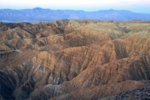
The Orocopia Mountains are located in Riverside County in southern California, United States, east of the Coachella Valley, west of the Chuckwalla Mountains, and south of Interstate 10 in the Colorado Desert. The range lies in an east-west direction, and is approximately 18 miles long. The Orocopia Mountains are north of and overlooking the Salton Sea and south of Joshua Tree National Park, with the Chocolate Mountains to the southeast and the scenic Mecca Hills just northwest.
Contents
- Map of Orocopia Mountains California USA
- Orocopia Mountains Wilderness AreaEdit
- Flora and faunaEdit
- HistoryEdit
- GeologyEdit
- Astronaut trainingEdit
- References
Map of Orocopia Mountains, California, USA
Orocopia Mountains Wilderness AreaEdit
The area is the Bureau of Land Management (BLM) designated and managed Orocopia Mountains Wilderness Area. The Orocopia Mountains are in the Colorado Desert section of the Sonoran Desert, adjacent to the Lower Colorado River Valley region. Just to the north is the Mecca Hills Wilderness Area.
Flora and faunaEdit
The Wilderness Area includes some remnant natural spring fed oasis with the only California native palm, Washingtonia filifera or the California Fan Palm.
HistoryEdit
The Bradshaw Trail passed through the mountains, the first recorded route to the Colorado River from Riverside, California.
GeologyEdit
The dramatic and variable terrain was shaped primarily by movements of the adjacent San Andreas Fault over millennia. Most notably, the Orocopia schist, a blueschist assemblage found in the range, matches the Pelona schist found over 250 km away in the San Gabriel Mountains along the San Andreas fault. Hill and Dibblee (1953) first noted this similarity (a piercing point), and used it to construct the first estimates of the offset on the fault.
Astronaut trainingEdit
The Orocopia Mountains offer considerable geologic variety and was one of the areas used for geologic field training by Caltech Professor of Geology, Leon T. Silver, for astronauts in preparation for the NASA Project Apollo Moon landing missions. This training included: