The Partizione delle Alpi ("Partition of the Alps", German: Einteilung der Alpen, French: Partition des Alpes) is a classification of the mountain ranges of the Alps, that is primarily used in Italian literature, but also in France and Switzerland. It was devised in 1926.
This classification system entails a division of the main arc of the Alps into the Alpi Occidentali (Western Alps), Alpi Centrali (Central Alps) and Alpi Orientali (Eastern Alps).
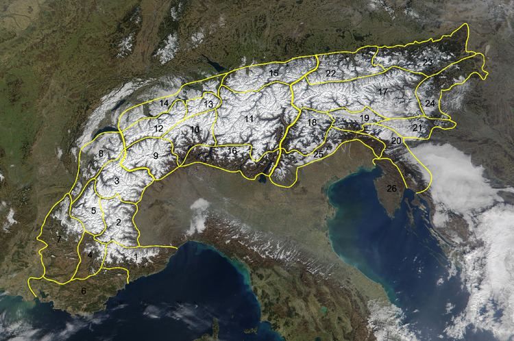
The basic structure is based on the three main divisions (Italian: parti, German: Teile). These were further subdivided into 26 sezione ("sections") and 112 gruppi ("groups").
The Alpi Occidentali ("Western Alps", German: Westalpen, French: Alpes Occidentales) in this classification run from the Bocchetta di Altare/Colle di Cadibona, usually accepted as the boundary between the Alps and the Apennines, to the Col Ferret (just west of the Great Saint Bernard) between the Aosta Valley and Valais (upper Rhone valley). Its highest peak is Mont Blanc (Monte Bianco) (4,810 m).The boundary between the western and central arc of the Alps is the line Ivrea – Aosta Valley – Italian Val Ferret – Col Ferret – Swiss Val Ferret – Martigny-Ville in the knee of Valais – eastern end of Lake Geneva near Montreux/VeveyThe Alpi Centrali ("Central Alps", German: Zentralalpen, French: Alpes Central) run from the Col Ferret to the Brenner Pass (Passo del Brennero). Their highest summit is Monte Rosa (4,611 m).The eastern section is bounded by the line of the Adige valley (near Verona, Vallagarina, Adige valley i.e.S. to Bolzano) – valley of the Eisack (Eisacktal to Franzensfeste, upper Wipptal valley) – Brenner – valley of the Sill (lower Wipptal) – Innsbruck – Lower Inn Valley as far as RosenheimThe Alpi Orientali ("Eastern Alps", German: Ostalpen, French: Alpes Orientales) run from the Brenner as far as Rijeka (ital. Fiume), including Istrien and Gorski kotar. The Großglockner (3,798 m) is the highest peak of the Eastern Alps.The term "Central Alps" should not be confused with the Central Alps within the north-to-south division of the Eastern Alps.
History and reception
This classification of the Alps was compiled in 1926 on the occasion of the IXth Congresso Geografico Italiano and published in the Nomi e limiti delle grandi parti del Sistema Alpino ("Names and Boundaries of the Major Elements of the Alpine System").
The system covered the entirety of the Alps and not just that part of the Alps that lay on Italian soil. In spite of that, the classification is focussed on Italy, because it does not employ the usual bipartite division, and in general the subdivisions usually used in other countries were ignored. It was seen as flawed because it included regions that, according to research, were not part of the Alps.
The following have been cited by Marazzi as basic shortcomings and inconsistencies:
the inclusion of the Massif des Maures, which does not belong to the Alpine system either tectonically or geologicallythe Monts de Vaucluse, Montagne de Lure and the Luberon Massif were not counted as pre-alps of the Dauphiné in French literature, but as part of Provence, because they lay within that region. Moreover, the Provence Alps also include the "Prealps of Digne" (Préalpes de Digne), that were placed under Prealpi di Provenza (Provence Prealps, French: Préalpes de Provence)in the Prealpi svizzere (Swiss Prealps) more northerly regions are included that, according to Swiss geographic literature, do not belong to the Alpine region, but to the Central Plateau, as part of the northern Alpine Forelandthe Alpi Noriche (Noric Alps) cover far too large an area in comparison with the groups given in Austrian literature (rather excessively the Tux Alps, the whole Tauern, the Alps of Styria and Carinthia are incorporated into the Noric Alps)the Alpi bavaresi (Bavarian Alps), the Alpi salisburghesi (Salzburg Alps) and the Alpi austriache (Austrian Alps) are based on archaic concepts, the terms are used entirely differently in the German-speaking regionthe inclusion of the Karst in a broad sense and Istria in the Alpine system, which, today, are considered part of the Dinaric AlpsMore up to date versions of this system are found in standard works like the Dictionnaire encyclopédique des Alpes (2006) or Il Grande Dizionario Enciclopedico delle Alpi (2007).
Comitato Geografico Nazionale Italiano (ed.): Nomi e limiti delle grandi parti del Sistema alpino. In L'Universo. Anno Vili, no. 9, Firenze, 1926.G. Bertoglio, G. De Simoni: Partizione delle Alpi (in 220 gruppi). Tipografia Alzani, Pinerolo, 1980.AA. VV.: Guida dei monti d'Italia. 60 vols., TCI-CAI, Milan, 1936–97.