
Population 40,075 (2015) Postcode(s) 2800 Postal code 2800 | Established 1846 Elevation 863 m | |
 | ||
Location 254 km (158 mi) from Sydney1,010 km (628 mi) from Brisbane777 km (483 mi) from Melbourne280 km (174 mi) from Canberra Weather 28°C, Wind SW at 13 km/h, 34% Humidity Points of interest Orange Botanic Gardens, Cook Park - Orange, Lake Canobolas, Orange Regional Gallery, Philip Shaw Wines | ||
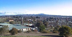
Orange /ˈɒrɪndʒ/ is a city in the Central West region of New South Wales, Australia. It is 254 kilometres (158 mi) west of the state capital, Sydney [206 kilometres (128 mi) on a great circle], at an altitude of 862 metres (2,828 ft). Orange had an estimated urban population of 40,075 as of June 2015 making the city a significant regional centre. According to the 2011 census, the key employment sectors within the City of Orange local government area include health care & social assistance, retail and the education & training sector. A significant nearby landmark is Mount Canobolas. With a peak elevation of 1,395 metres (4,577 ft) it gives commanding views of the district.
Contents
- Map of Orange NSW 2800 Australia
- History
- Industries
- Primary and Public schools
- Secondary schools
- Tertiary education
- Churches
- Suburbs
- Climate
- Mining
- Winemaking
- Wineries in Orange
- Media
- Clubs and entertainment
- Roads
- Public transport
- Air
- Railways
- Sister cities
- Attractions
- Clubs in Orange
- Historic Orange buildings
- Historic houses
- References
Map of Orange NSW 2800, Australia
Orange is the birthplace of poets Banjo Paterson and Kenneth Slessor, although Paterson lived in Orange for only a short time as an infant. Walter W. Stone, book publisher (Wentworth Books) and passionate supporter of Australian literature, was also born in Orange. The first Australian Touring Car Championship, known today as V8 Supercar Championship Series, was held at the Gnoo Blas Motor Racing Circuit in 1960.
History
In 1822 Captain Percy Simpson marched into the Wellington District and established a convict settlement which was called "Blackman's Swamp" after James Blackman; Simpson had employed James Blackman as a guide because he had already accompanied an earlier explorer, John Oxley into that region.
In the late 1820s, the surveyor J. B. Richards worked on a survey of the Macquarie River below Bathurst and also of the road to Wellington. On a plan dated 1829, he indicated a village reserve, in the parish of Orange. Sir Thomas Mitchell named the parish Orange, as he had been an associate of the Prince of Orange in the Peninsular War, when both were aides-de-camp to the Duke of Wellington, whose title was bestowed on the valley to the west by Oxley.
Initial occupation by British graziers began in late 1829, and tiny settlements eventually turned into larger towns as properties came into connection with the road. In 1844, the surveyor Davidson was sent to check on encroachments onto the land reserved for a village, and to advise on the location for a township. His choices were Frederick's Valley, Pretty Plains, or Blackman's Swamp.
Blackman's Swamp was chosen, and it was proclaimed a village and named Orange by Major Thomas Mitchell in 1846 in honor of Prince William of Orange. At nearby Ophir, a significant gold find in Australia was made in 1851, resulting in a sporadic population movement which is known as the Australian gold rush. Additional gold finds in nearby areas led to the establishment of Orange as a central trading centre for the gold.
The growth of Orange continued as the conditions were well suited for agriculture, and in 1860 it was proclaimed a municipality. The railway from Sydney reached Orange in 1877. In 1946, 100 years after it was first being established as a village, Orange was proclaimed as a minor city.
Industries
Orange is a well-known fruit growing district, and produces apples, pears, and many stone fruits such as cherries, peaches, apricots, and plums; oranges are not grown in the area, since its climate is too cool. In recent years, a large number of vineyards have been planted in the area for rapidly expanding wine production. The growth of this wine industry, coupled with the further development of Orange as a gourmet food capital, has ensured Orange's status as a prominent tourism destination.
Other large industries include:
Orange is also the location of the headquarters of the New South Wales Department of Industry (Department of Industry, Skills and Regional Development, the New South Wales Department of Primary Industries).
Primary and Public schools
The following Primary Schools are not within the city limits of Orange but are located within the rural fringe of Orange:
Secondary schools
Tertiary education
Orange Regional Conservatorium
Churches
Suburbs
The following are listed as the suburbs within Orange City Council, according to the New South Wales Division of Local Government:
Climate
Orange has a mild temperate climate with warm summers and cool winters, and with rainfall distributed fairly evenly throughout the year. Under the Köppen climate classification scheme, it has a moderate oceanic climate (Cfb) with subtropical highland (Cwb) influences, due to its elevation. Compared with most population centres in Australia it has colder winters, especially in terms of its daytime maximum temperatures. In summer, the average (and absolute) maximum temperatures are also lower than in most inland centres, on account of its elevation. The climate has enabled the area to be a major apple and pear producer, and more recently a centre for cool-weather wine production.
Owing to its inland location, the humidity is low in the summer months with the dewpoint typically around 10 °C. Having 99.8 clear days annually, it is still cloudier than the coastal areas of Sydney and Wollongong (104 and 107 clear days, respectively). Additionally, it is one of the only cities in Australia to receive regular snow, with moderate to occasionally heavy snowfalls occurring several times each winter. Its claim as Australia's snowiest city is sometimes disputed by Ballarat in Victoria and nearby Lithgow.
Mining
Cadia-Ridgeway Mine is a large open cut gold and copper mine located about 20 kilometres south of Orange, the mine has been developed throughout the 1990s employing several thousand employees with an expected lifespan of several decades. Cadia is the second largest open cut mine in Australia after the Super Pit at Kalgoorlie. Large mineral deposits are also being uncovered from the more recently developed Ridgeway underground mine which is adjacent to the Cadia Mine.
The mine is operated by Newcrest Mining. Cadia-Ridgeway is one of two gold mines Newcrest currently operates in Australia, the other being Telfer in Western Australia. The company also owns and operates the Gosowong Mine in Indonesia and the Lihir mine in Papua New Guinea (both gold mines) amongst others .
Winemaking
The Orange wine region is defined as the area above 600m in the local government areas of Orange, Cabonne and Blayney and can be usefully described as a circle around Orange. The Orange region is good for grapegrowing and winemaking due to a combination of geology, soils, climate and temperature. Together these factors combine to produce grapes and wine of distinct flavours and colour. The climate perhaps plays the biggest part in giving Orange some distinct natural advantages – the cool temperatures during most of the growing season coupled with dry autumn conditions are ideal for grape growing.
Wineries in Orange
Wineries that use Orange region grapes in their wines include Brokenwood Wines (Hunter Valley based), Logan (Mudgee), Tamburlaine (Hunter Valley), Gartelmann (Hunter Valley), Windowrie (Central Ranges) and Lowe Wines (Mudgee). In 2007, South Australian based Penfolds winery released the 2007 Penfolds Bin 311 Orange Region Chardonnay.
Media
Orange is served by several radio stations, including 105.1 2GZFM, 105.9 Star FM, FM107.5 Orange Community Radio, 103.5 Rhema FM, HIT Country 88 FM and 2EL 1089AM – a commercial station that gets most of its programming from 2SM in Sydney. The Australian Broadcasting Corporation (ABC) also broadcasts from four radio stations in Orange including ABC Local Radio (2CR) on 549AM and three national networks – ABC Classic FM on 102.7 FM, ABC Radio National on 104.3 FM, and Triple J on 101.9 FM.
The city receives five network television stations – Prime7 (a Seven Network affiliate), WIN TV (a Ten Network affiliate), Southern Cross Nine (a Nine Network affiliate), ABC TV and SBS One. All networks also provide additional digital-only television stations.
Of the three commercial networks, Prime and WIN air 30-minute local news bulletins on weeknights, both produced locally and broadcast from studios outside the region (Canberra and Wollongong, respectively). WIN also produces a statewide late night news bulletin for southern New South Wales and the Australian Capital Territory, while Southern Cross Ten provides short local news updates throughout the day.
Subscription television service Foxtel is available in Orange and the surrounding region via satellite.
The local newspapers are the Central Western Daily, the Midstate Observer and Orange City Life.
Clubs and entertainment
Orange has several music clubs which meet regularly. The Orange Blues Club meets at the Victoria Hotel. The Orange Blues Club also hold an annual Blues Music Festival – Black Stump Blues Festival The Orange Jazz Club meets 1st Sunday monthly at the Royal Hotel.
Roads
Orange is situated on the Mitchell Highway, linking the city to Molong, Wellington, Dubbo and Bourke to the north west, and to Bathurst to the east and from there to Sydney via the Great Western Highway (260 km or 160 mi). Due west are Parkes (100 km or 62 mi) and Forbes (125 km or 78 mi), which is midway along the Newell Highway, running from Brisbane, Queensland to Melbourne, Victoria. In 2007 a bypass road, known as the northern distributor road, was opened for use after decades of planning.
Public transport
Orange Buslines operate a number of routes within the city and a service to the neighbouring city of Bathurst.
Newman's Bus Service operates route 2 on weekdays to Blayney.
NSW TrainLink operate several coach services with connecting train services from Lithgow to Sydney, as well as a less frequent Coach service to Cootamundra for connection to Melbourne. Australia Wide Coaches operate a daily coach service to Sydney railway station.
Air
Orange is also serviced by a regional-class airport, Orange Airport, located approximately 15 km to the south of the city, in an area known as Huntley.
Railways
Orange has two railway stations. The main station, on the Main Western Line to Bourke, was opened in 1877 and is served by the daily NSW TrainLink Central West XPT service between Sydney and Dubbo and the weekly Outback Xplorer service between Sydney and Broken Hill. A smaller station, opened in 1970, known as Orange East Fork, lies on the branch line to Broken Hill and is served by the weekly Indian Pacific service to Perth.
Sister cities
Orange is a sister city to: