
Population 32,797 (2015) (44th) Time zone AWST (UTC+8) Local time Saturday 10:31 AM | Established 1893 Elevation 468 m | |
 | ||
Area 75.1 km (29.0 sq mi) (2011 urban) Weather 28°C, Wind S at 13 km/h, 34% Humidity Points of interest Eyre Bird Observatory, Karlkurla Bushland Park, Museum of the Goldfields | ||
Kalgoorlie goldfields western australia
Kalgoorlie, part of the City of Kalgoorlie-Boulder, is a city in the Goldfields-Esperance region of Western Australia, Australia, located 595 kilometres (370 mi) east-northeast of Perth at the end of the Great Eastern Highway. The town was founded in 1893 during the Coolgardie gold rush, and is located close to the so-called "Golden Mile". It is also the ultimate destination of the Goldfields Water Supply Scheme and the Golden Pipeline Heritage Trail.
Contents
- Kalgoorlie goldfields western australia
- Map of Kalgoorlie Boulder WA Australia
- History
- Industry and commerce
- Mining
- Super Pit
- Culture
- Arts
- Sports
- Attractions
- Accommodation
- Suburbs
- Rail
- Buses
- Air
- Road
- Media
- Climate
- Education
- Primary schools
- High schools
- Universities
- TAFE
- Notable people
- References
Map of Kalgoorlie - Boulder WA, Australia
At June 2015, Kalgoorlie (including Boulder), had an estimated urban population of 32,797.
The name Kalgoorlie is derived from the Wangai word Karlkurla, meaning "place of the silky pears".
History
In January 1893, prospectors Patrick (Paddy) Hannan, Tom Flanagan, and Dan O'Shea were travelling to Mount Youle when one of their horses cast a shoe. During the halt in their journey, the men noticed signs of gold in the area and decided to stay and investigate. On 17 June 1893, Hannan filed a Reward Claim, leading to hundreds of men swarming to the area in search of gold and Kalgoorlie, originally called Hannan's Find, was born.
The population of the town was 2,018 (1,516 males and 502 females) in 1898.
The mining of gold, along with other metals such as nickel, has been a major industry in Kalgoorlie ever since, and today employs about one-quarter of Kalgoorlie's workforce and generates a significant proportion of its income. The concentrated area of large gold mines surrounding the original Hannan's find is often referred to as the Golden Mile, and was sometimes referred to as the world's richest square mile of earth.
In 1901 the population of Kalgoorlie was 4,793 (3,087 males and 1,706 females) which increased to 6,790 (3,904 males and 2,886 females) by 1903.
The 3 ft 6 in (1,067 mm) narrow-gauge Government Eastern Goldfields Railway line reached Kalgoorlie station in 1896, and the main named railway service from Perth was the overnight sleeper train The Westland which ran until the 1970s. In 1917, a 4 ft 8 1⁄2 in (1,435 mm) standard gauge railway line was completed, connecting Kalgoorlie to Port Augusta, South Australia across 2,000 kilometres (1,243 mi) of desert, and consequently the rest of the eastern states. The standardisation of the railway connecting Perth (which changed route from the narrow-gauge route) in 1968 completed the Sydney–Perth railway, making rail travel from Perth to Sydney possible; the Indian Pacific rail service commenced soon after. During the 1890s, the Goldfields area boomed as a whole, with an area population exceeding 200,000, composed mainly of prospectors. The area gained a notorious reputation for being a "wild west" with bandits and prostitutes. This rapid increase in population and claims of neglect by the state government in Perth led to the proposition of the new state of Auralia but, with the sudden diaspora after the Gold Rush, these plans fell through.
Places, famous or infamous, that Kalgoorlie is noted for include its water pipeline, designed by C. Y. O'Connor and bringing in fresh water from Mundaring Weir near Perth, its Hay Street brothels, its two-up school, the goldfields railway loopline, the Kalgoorlie Town Hall, the Paddy Hannan statue/drinking fountain, the Super Pit and Mount Charlotte lookout. Its main street is Hannan Street, named after the town's founder. One of the infamous brothels also serves as a museum and is a major national attraction.
Kalgoorlie and the surrounding district was serviced by an extensive collection of suburban railways and tramways, providing for both passenger and freight traffic.
On 20 April 2010, Kalgoorlie was shaken by a an earthquake that reached 5.0 on the richter scale. The epicentre was 30 km north east of the town. The quake caused damage to a number of commercial hotels and historic buildings along Burt Street in Boulder. The entire Burt St. precinct was evacuated until 23 April. Work in the Superpit and many other mines around Kalgoorlie was stopped. Two people suffered minor injuries as a result of the quake.
On 30 August 2016, Kalgoorlie was the scene of a protest that turned violent over the death of Elijah Doughty, a fourteen-year-old Indigenous Australian who was killed in a crash with a utility vehicle while riding on a stolen motorcycle. Several police officers were injured during the riot and at least ten people were charged.
Industry and commerce
Kalgoorlie–Boulder is a regional centre and has a Chamber of Commerce and a Chamber of Minerals and Energy.
Mining
Since 1992, Kalgoorlie has been home to the Diggers & Dealers conference, held annually in August. It is Australia's premier international mining conference.
It is also home to the Australian Prospectors & Miners' Hall of Fame.
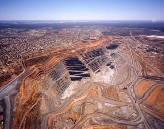
Super Pit
The Super Pit is an open-cut gold mine approximately 3.6 kilometres (2.2 mi) long, 1.6 kilometres (1.0 mi) wide and 512 metres (1,680 ft) deep. It was created by Alan Bond, who bought up a number of old mining leases in order to get the land area needed for the Super Pit. Occasionally the excavating has revealed an old shaft containing abandoned equipment and vehicles from the earlier mines.
The mine operates 24 hours a day, 7 days a week, and a visitor centre overlooks it. The mine blasts at 1:00 pm every day, unless winds would carry dust over the town. Each of the massive trucks carries 225 tonnes of rock and the round trip takes about 35 minutes, most of that time being the slow uphill haul. Employees must live in Kalgoorlie; it is not a fly-in fly-out operation. The mine is expected to be productive until about 2029.
Culture
Kalgoorlie–Boulder has a dynamic and diverse cultural scene.
Arts
Kalgoorlie–Boulder has many arts organisations and practising artists.
Sports
Kalgoorlie–Boulder's location, being approximately 600 km from Perth, contributes to high levels of participation in Australian rules football, netball, basketball, rugby league, soccer, hockey and cricket. Other popular sports in Kalgoorlie include tennis, lawn bowls, roller derby, rugby union and swimming.
Kalgoorlie also has an international squash tournament held every year at the YMCA.
In a statewide sense, the semi-professional Goldfields Giants basketball team competes in the State Basketball League (SBL), and were SBL Champions in 2007 and 2008.
The Goldfields Titans play in the Western Australia Rugby League Harvey Norman Premiership state rugby league competition. Home games are at the Oasis playing fields on Saturday afternoons.
Horse racing is also very popular in the city, and Kalgoorlie–Boulder is home to the internationally recognised annual "Race Round".
Attractions
Kalgoorlie–Boulder – the largest settlement for many hundreds of kilometres, with many employees at the Super Pit – is the centre of the area's social life. Of particular interest is the Kalgoorlie–Boulder Racecourse, a horse racing venue. Also well known in the area are the Kalgoorlie Skimpies, ladies employed by each pub who walk around in their underwear or burlesque outfits to attract punters and who expect a fee in return. There are two grass sports ovals in the area and a cinema showing recent international releases.
Accommodation
Kalgoorlie has historical hotels still in operation:
Many hotels have been put to private use, including:
Hotels that have disappeared from the city include:
Suburbs
The Kalgoorlie–Boulder metropolitan area consists of the following suburbs:
Known as the home of the Super Pit, it is one of Kalgoorlie–Boulder's historical suburbs featuring many buildings and landmarks dating as far back as 1882. It was once the central business district for the Town of Boulder, but since amalgamation with Kalgoorlie, it is now more of a historical local centre. Boulder has its own post office, town hall and many hotels along its main thoroughfare, Burt Street. A significant refurbishment has been commenced as part of the 'Royalties for Regions' initiative.
A new housing suburb located next to the Kalgoorlie-Boulder Airport, which was recently expanded.
This area derives its name from the golf course that once occupied the area. It was released to provide affordable property to a growing population in Kalgoorlie–Boulder. Fairways features a private primary school, church, caravan park and small business.
Adeline was originally constructed around 1970 by the State Housing Commission. The suburb was built on the "Radburn concept", with houses facing away from the street and common pathways linking homes. The area has been plagued by antisocial problems. In 2003, a significant urban renewal project, including the renaming of the suburb to Golden Grove and re-aligning of homes was commenced. The project has seen some success but has yet to fully eliminate antisocial problems within the area.
See Broadwood.
Located in Kalgoorlie's far north. Hannans was the first suburb to have its own independent shopping centre ("Hannans Boulevard") which includes a Coles Supermarket. The area also has a primary school and an 18-hole golf course. The original course was not formally grassed but was recently refurbished. Several surrounding golf clubs joined together to form one club known as 'The Goldfields Golf Club'. A dam has been constructed to service what is now a luxury desert golf course and club. Alongside the golf course project has been the development and release of Greenview estate. It lies on the western border of Hannans. This ongoing project has been designed as an environmentally friendly estate, and will eventually consist of over 2000 homes, apartments and facilities such as parks and schools. As one of Kalgoorlie's highest growth areas there has been a proposal for a new alternative route, out of the suburb onto the Kalgoorlie Bypass, to avoid traffic problems on the already heavily used Graeme Street which is a direct route to the city centre. Other developments include 'Karkurla Rise' and 'Karkurla View' which have added an additional 400 homes to the area.
The central business district. Hannan Street, named after Paddy Hannan, is the Kalgoorlie's main street and stretches The length of the suburb. The western side of the suburb consists of housing and some light industry. The eastern side contains retail chains, banks, the police station, court house, restaurants, hotels, tourist attractions, schools, university and TAFE.
One of Kalgoorlie's oldest suburbs. Much like other older suburbs, almost every street is parallel with Hannan Street in Central Kalgoorlie and are noticeably wide. It houses North Kalgoorlie Primary School, small businesses, a medical practices, a hotel, tavern and a non-maintained 18 hole golf course.
Much smaller today than it originally was before the Super Pit expansion. It's located at the far east end of Lamington between the northern Goldfields railway and Goldfields Highway.
Officially O'Connor is the south-east section of the suburb of Somerville. Much of the area is increasingly now known as O'Connor. It is home to a primary school, private high school Goldfields Baptist College and shopping facilities. It also houses the city's only recreation centre.
A narrow suburb following Piccadilly street between Central Kalgoorlie and Lamington. It features the city's regional hospital, small businesses, a hotel, sporting arena and two grassed ovals.
Somerville marks the end of Great Eastern Highway that stretches between Kalgoorlie–Boulder and Perth. Much of the area is now referred to locally as O'Connor. Somerville contains residential area, schools, retail shops, light industry and some horse stables. In the past it also contained market gardens.
Stretching from Boundary Street, Kalgoorlie to Holmes Street, Golden Grove and bordering with Central Kalgoorlie, O'Connor and Golden Grove. South Kalgoorlie is mostly residential but also contains the Kalgoorlie–Boulder Racecourse, schools, some light industrial and small businesses. The suburb was expanded in the mid-1990s to include a sub-division named 'Sport of Kings' on Maxwell Street, using a surplus of land from the racecourse.
A residential only subdivision within Fairways estate along Burt Street.
Kalgoorlie's main industrial area. It is the first suburb as you approach Kalgoorlie on the Great Eastern Highway. It features the city's airport and small, medium and heavy industrial. Currently under expansion further west (ANZAC Drive Industrial Estate.)
The western tip of Lamington was built in the 1980s. It includes one shop, sporting facilities and an arboretum nature reserve.
The small existing area features mostly housing with one small primary school. It is also home to the Mount Charlotte mine shaft and Nanny Goat Hill. KCGM, owned by Barrick Gold and Newmont Mining, owner of the Super Pit to the south, has begun mining the Hidden Secret orebody, between 215 metres (705 ft) and 440 metres (1,440 ft) below the surface of Williamstown, using the Mount Charlotte shaft as access.
Rail
The town is located on the main East-West rail corridor across Australia. the Transwa Prospector operates once to twice daily passenger train services from Kalgoorlie to Perth. The Indian Pacific train also stops here, operating weekly in each direction.
Buses
Town bus services are provided by TransGoldfields, there are three town routes as well as school services. Transwa also operates road coaches that service the town.
Air
Commercial air services connect Kalgoorlie–Boulder with Melbourne and Perth, operating out of the Kalgoorlie-Boulder Airport. Airlines that provide regular flights include Alliance Airlines, Qantas, QantasLink and Virgin Australia. There is a locally owned and operated charter company with a flight school, Goldfields Air Services.
Road
Kalgoorlie is linked to Perth by the Great Eastern Highway, and is also on the Goldfields Highway.
Media
Radio
Radio Services available in Kalgoorlie:
Television Television services available include:
The programming schedule is mainly the same as the Seven, Nine and Ten stations in Perth with variations for News bulletins, sport telecasts such as the Australian Football League and National Rugby League, children's and lifestyle programs and infomercials or paid programming.
GWN7 maintains a newsroom in the city. The GWN7 bureau provides coverage of the surrounding area for the station's nightly 30-minute news program, GWN7 News, at 5:30 pm on weeknights.
A Foxtel subscription television service is available via satellite.
Newspapers
The local newspaper for the Kalgoorlie–Boulder and Goldfields region is The Kalgoorlie Miner.
Newspapers from Perth including The West Australian and The Sunday Times are also available, as well as national newspapers such as The Australian and The Australian Financial Review.
Climate
Kalgoorlie has a semi-arid climate with hot summers and mild winters. The average annual rainfall is 260mm on an average of 68 days and, while the average rainfall is fairly evenly distributed throughout the year, there is considerable variation from year to year.
January is the hottest month with an average maximum temperature of 33.6 °C, but temperatures above 40.0 °C occur nearly once a week when hot, dry, north to northeasterly winds arrive. Such high temperatures are usually followed by a cool change from the south and occasionally with a thunderstorm.
By contrast, winters are cool, with July average maximum and minimum temperatures being 16.5 °C and 4.8 °C, respectively. Cold, wet days with a maximum below 12.0 °C occur about once every winter. The lowest maximum temperature recorded is 7.2 °C on 19 July 1961. Overnight temperatures fall below freezing about four times in a typical winter. Such events occur on clear nights following a day of cold southerly winds.
Education
There are 10 primary schools, 4 high schools and 1 university in the Kalgoorlie–Boulder area.