
Existed: 1912 – present Constructed 1924 | Length 470.2 km | |
 | ||
Ohio state route 7 through steubenville ohio
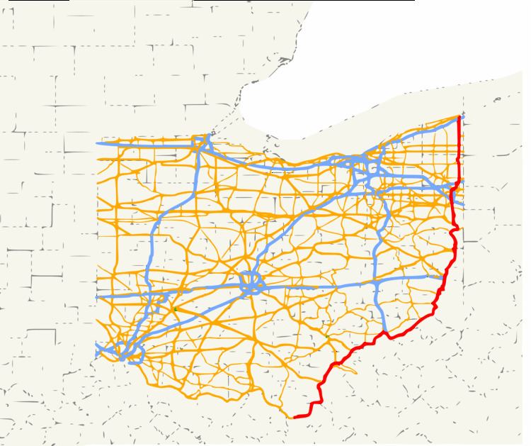
State Route 7 (SR 7), formerly known as Inter-county Highway 7 until 1921 and State Highway 7 in 1922, is a north–south state highway in the southern and eastern portions of the U.S. state of Ohio. At just over 292 miles (470 km) in length, it is the longest state route in Ohio. Its southern terminus is an interchange with U.S. Route 52 (US 52) just west of Chesapeake. Its northern terminus also serves as the eastern terminus of SR 531 in Conneaut. The path of SR 7 stays within five miles (8.0 km) of the Ohio River (Ohio's border with West Virginia) for the southern portion, with the river being visible from much of the route. The road also remains within 10 miles (16 km) of the Pennsylvania state line for the northern portion.
Contents
Route description
SR 7 starts in Chesapeake and for about 100 miles (160 km) it runs along the Ohio River. Then it heads north along SR 11 & US 30 from East Liverpool to Rogers. After it turns north in Rogers, it heads up to Youngstown. Then the highway heads east overlapped with US 62. After that shared alignment, the highway then heads north again in Hubbard through a lot of small towns to its northern terminus in Conneaut.
History
In 1912, Intercounty Highway 7 ran along the Ohio River, from Elizabethtown to the Pennsylvania state line at Pomeroy
In 1923, the route was at its greatest extent, the northern terminus of the route was extended from East Liverpool to Conneaut.
In 1927, the southern segment running from Chesapeake to the Indiana state line near Elizabethtown was deleted to make way for US 52 and a small segment of US 50
Chesapeake and Proctorville bypass
The Chesapeake bypass was first proposed in 1953.
In 1961, the US 52 expressway opened from Chesapeake westward towards Sheridan. The original eastern terminus of the four-lane divided highway was at the current Chesapeake northbound-only exit ramp east of Tallow Ridge Road. US 52 originally crossed at the present-day Robert C. Byrd Bridge that connects Chesapeake to Huntington, West Virginia. In 1979, the US 52 designation moved to the Nick Joe Rahall II Bridge as tolls on that span were removed that year; the segment east of the Rahall Bridge to the Chesapeake interchange was renumbered to SR 7.
Ten years later, the four-lane expressway was extended eastward to an incomplete trumpet interchange just east of Big Branch Road. A four-lane connector route from the partially complete interchange to the foot of the Robert C. Byrd Bridge at SR 527 was completed. At the same time, the two-lane Chesapeake interchange ramp just east of Tallow Ridge Road was converted to a northbound-only exit ramp. The abrupt terminus at Chesapeake was envisioned to connect to Proctorville.
On May 31, 2002, ground was broken for Phase 1-A of the Proctorville bypass. Phase 1-A entailed a two-lane connector road from the East Huntington Bridge to Irene Road, with the original loop ramp from the bridge to State Route 7 being modified into an access road. Phase 1-B was designated from Irene Road to State Route 7 near Fairland East Elementary in Rome. Phase 2 was envisioned from Irene Road west to Chesapeake. The total cost was originally estimated to be at $165 million.
On April 27, 2003, Phase 1-A of the Proctorville bypass opened to traffic. The $6.5 million, one-mile (1.6 km) section of three-lane roadway was opened from the foot of the East Huntington Bridge to Irene Road and signed as SR 607.
On June 3, 2003, bids were opened for Phase 1-B from Irene Road to SR 7 near Fairland East Elementary. The projected cost of the 4.5-mile (7.2 km) segment was originally $27 million, however, when the bids were let, the cost had decreased to $24.3 million. The lowest bid, which was also accepted, came in at $22.1 million. The road was designed as a two-lane limited-access facility on a four-lane right-of-way. Construction began on August 4, with an original estimated completion date of June 30, 2005.
An unusual amount of rain, blamed on two hurricanes, caused major delays. More than one-dozen major slips along Phase 1-B required an additional $30 million in repairs and the purchase of additional land for highwall excavations. Another change was the design of the roadway; originally projected to be widened in the future when higher traffic counts warrant the expansion, it was designed on wide right-of-way with no grade separation between the opposing lanes. During the repair of the slips, a terraced roadway was constructed to separate the future southbound lanes from the northbound by a highwall when the roadway is expanded to four lanes.
Other cost overruns had pushed the cost of construction to $62 million total, which included Phases 1-A and 1-B, up from the original estimates of $32 million. The primary cause was rapidly increasing land values and "unchecked zoning" along the project's projected right-of-way along with geo-technical problems with rocky soil. Property values along the projected route, for instance, increased 91.5% from 1992 to 2001 alone.
In October 2006, a small 1⁄2-mile (0.80 km) segment of the Phase 1-B bypass opened to traffic between SR 607 and Irene Road intersection to SR 775. The remainder, east to SR 7 near Fairland East Elementary, opened on December 8, 2006. It includes intersections with SR 775, Kinley Avenue, and SR 7. Upon completion, phases 1-A and 1-B were signed as SR 7; the bypass from the SR 775 junction to the loop at the East Huntington Bridge was co-numbered with SR 775.
Phase 2 of the bypass, from the Chesapeake bypass to Irene Road at Proctorville, has not been funded. Funding which had been previously promised by the Ohio Department of Transportation (ODOT) was later denied. Phase 2 is estimated to cost $76 million to complete. Also due to the construction delays (slips) on the bypass from SR 775 to Fairland East Elementary School (Phase 1-B), the design of Phase 2 may be realigned to prevent slips during construction.
Pomeroy Bypass
The Pomeroy bypass from Middleport east to US 33 was completed in 1968. At the time of completion, the bypass was two lanes but was upgraded to four lanes, divided, in 1976 from SR 143 to US 33 near Rock Springs. The bypass was extended east in 2000 from Rock Springs to a partial diamond interchange with SR 7 as a four-lane divided expressway. It was initially signed just SR 7. The diamond interchange was later completed with all connections, and the highway was extended eastward to Ravenswood, West Virginia as US 33.
State Route 7 Alternate in Bridgeport
State Route 7 Alternate (SR 7A) is a short 0.72-mile-long (1.16 km) connecting loop signed as SR 7 that serves as a link from SR 7, US 40, and US 250 to I-70 in Bridgeport. Its western (southern) terminus is at SR 767, and its eastern (northern) terminus is along US 40 at its intersection with US 250 and the northern terminus of SR 767. SR 7A begins at the intersections of Howard Street and SR 767 (South Lincoln Avenue). SR 7A continues west as Howard Street until it intersects Marion Street. It then runs north as Marion Street, intersects I-70, and then intersects US 40, Main Street. SR 7A continues east on US 40 until it ends at US 250 and SR 767, just 370 feet (110 m) west of the West Virginia state line.
The entire route is in Bridgeport, Belmont County.
State Route 767
State Route 767 (SR 767) is a north–south state highway in the eastern portion of the U.S. state of Ohio. Currently, it is signed as an alternate route of SR 7. Its southern terminus is at an exit ramp on SR 7 in Bridgeport. The route serves as a connector from northbound SR 7 to SR 7 Alternate, US 40, and US 250. The route's northern terminus is where these U.S. routes overlap eastbound to cross the Ohio River into West Virginia. SR 7A serves as a connector for all of these routes to I-70.
Business State Route 7 from Middleport to Pomeroy
Business State Route 7 stretched from 1 3⁄4 miles (2.8 km) west of Middleport to about 4 miles (6.4 km) east of Pomeroy. The route followed the former alignment of State Route 7 that was replaced by the Pomeroy Bypass, and ran through the downtown areas of Middleport and Pomeroy. It joined with State Route 833 (the former alignment of U.S. Route 33) from one mile (1.6 km) west of Pomeroy to 1 3⁄4 miles (2.8 km) east of Pomeroy, including a brief concurrency with State Route 124, and then headed northeast to the eastern U.S. Route 33/State Route 7 interchange. The route was deleted between 2013 and 2015.
Route 7T
State Route 7T (SR 7T) was a 0.36-mile-long (0.58 km) future route beginning at US 62 in Youngstown. The entire route was concurrent with US 62T. SR 7T and US 62T were removed on May 2, 2007.