
Traditional Chinese 羅布泊 Hanyu Pinyin IPA [lwǒpû pʰwó] | Simplified Chinese 罗布泊 Wade–Giles Lo-pu P'o Traditional Chinese 羅布淖爾 | |
 | ||
Lop Nur or Lop Nor (from a Mongolian name meaning "Lop Lake") is a former salt lake in China, now largely dried-up, located between the Taklamakan and Kumtag deserts in the southeastern portion of Xinjiang Uygur Autonomous Region in the People's Republic of China. Administratively, the lake is in Lop Nur township (罗布泊镇 pinyin: Luóbùpō zhèn, also known as Luozhong 罗中, pinyin: Luō zhōng) of Ruoqiang County, which in its turn is part of the Bayingolin Mongol Autonomous Prefecture.
Contents
- Map of Lop Nur Ruoqiang Bayingol China
- History
- Lop Nur Nuclear Weapons Test Base
- Transportation
- Archaeological sites around Lop Nur
- Loulan
- Xiaohe Burial Site
- Qwrighul
- Miran
- References
Map of Lop Nur, Ruoqiang, Bayingol, China
The lake system into which the Tarim River and Shule River empty is the last remnant of the historical post-glacial Tarim Lake, which once covered more than 10,000 km2 (3,900 sq mi) in the Tarim Basin. Lop Nur is hydrologically endorheic— it is landbound and there is no outlet. The lake measured 3,100 km2 (1,200 sq mi) in 1928, but has dried up due to construction of dams which blocked the flow of water feeding into the lake system, and only small seasonal lakes and marshes may form. The dried-up Lop Nur Basin is covered with a salt crust ranging from 30 cm to 1 m in thickness.
Lop Nur has been used as a nuclear testing site, and since the discovery of potash at the site in the mid-1990s it is also the location of a large-scale mining operation.
History
From around 1800 BC, until the 9th century the lake supported a thriving Tocharian culture. Archaeologists have discovered the buried remains of settlements, as well as several of the Tarim mummies, along its ancient shoreline. Former water resources of the Tarim River and Lop Nur nurtured the kingdom of Loulan since the second century BC, an ancient civilization along the Silk Road, which skirted the lake-filled basin. Loulan became a client-state of the Chinese empire in 55 BC, renamed Shanshan. Marco Polo in his travels passed through the Lop Desert, and the famous explorers Ferdinand von Richthofen, Nikolai Przhevalsky, Sven Hedin and Aurel Stein visited and studied the area. It is also likely that Swedish soldier Johan Gustaf Renat had visited the area when he was helping the Zunghars to produce maps over the area in the eighteenth century.
The lake was given various names in ancient Chinese texts. In Shiji it was called Yan Ze (鹽澤, literally Salt Marsh), indicating its saline nature, and near which was located the ancient Loulan Kingdom. In Hanshu it was called Puchang Hai (蒲昌海, literally Sea of Abundant Reed) and was given a dimension of 300 to 400 li (roughly 120–160 km) in length and breadth, indicating it was once a lake of great size. These early texts also mentioned the belief, mistaken as it turns out, that the lake joins the Yellow River through an underground channel as the source of the river.
The lake was referred to as the "Wandering Lake" in the early 20th century due to the Tarim River changing its course, causing its terminal lake to alter its location between the Lop Nur dried basin, the Kara-Koshun dried basin and the Taitema Lake basin. This shift of the terminal lake caused some confusion amongst the early explorers as to the exact location of Lop Nur. Imperial maps from the Qing Dynasty showed Lop Nur to be located in similar position to the present Lop Nur dried basin, but the Russian geographer Nikolay Przhevalsky instead found the terminal lake at Kara-Koshun in 1867. Sven Hedin visited the area in 1900-1901 and suggested that the Tarim river periodically changed its course to and fro between its southbound and northbound direction, resulting in a shift in the position of the terminal lake. The change in the course of the river, which resulted in Lop Nur drying up, was also suggested by Hedin as the reason why ancient settlements such as Loulan had perished.
In 1921, due to human intervention, the terminal lake shifted its position back to Lop Nur. The lake measured 2400 km2 in area in 1930-31. In 1934 Sven Hedin went down the new Kuruk Darya ('Dry River') in a canoe. He found the delta to be a maze of channels and the new lake so shallow that it was difficult to navigate even in a canoe. In 1900 he had walked the dry Kuruk Darya in a caravan. In 1952 the terminal lake then shifted to Taitema Lake when the Tarim River and Konque River were separated through human intervention, and Lop Nur dried out again by 1964. In 1972, the Great West Sea Reservoir (Daxihaizi, 大西海子) was built at Tikanlik, water supply to the lake was cut off, and all the lakes for the most part then dried out, with only small seasonal lakes forming in local depressions in Taitema. The loss of water to the lower Tarim River Valley also led to the deterioration and loss of poplar forests and tamarix shrubs that used to be extensively distributed along the lower Tarim River Valley forming the so-called 'Green Corridor'. In 2000, in an effort to prevent further deterioration of the ecosystem, water was diverted from Lake Bosten in an attempt to fill the Taitema Lake. The Taitema Lake however had shifted 30 to 40 kilometres (19 to 25 mi) westwards during the past 40 years due in part to the spread of the desert. Another cause of the destabilization of the desert has been the cutting of poplars and willows for firewood; in response, a restoration project to reclaim the poplar forests was initiated.
The Kara-Koshun dried basin may be considered part of the greater Lop Nur.
On 17 June 1980, Chinese scientist Peng Jiamu disappeared while walking into Lop Nur in search of water. His body was never found, and his disappearance remains a mystery. 3 On June 1996, the Chinese explorer Yu Chunshun died while trying to walk across Lop Nur.
Lop Nur Nuclear Weapons Test Base
China established the Lop Nur Nuclear Test Base on 16 October 1959 with Soviet assistance in selection of the site, with its headquarters at Malan, about 125 km (78 mi) northwest of Qinggir. The first Chinese nuclear bomb test, codenamed "596", was tested at Lop Nur in 1964. The PRC detonated its first hydrogen bomb on 17 June 1967. Until 1996, 45 nuclear tests were conducted. In 2009, Jun Takada, a Japanese scientist known for prominently opposing the tests as "the Devil's conduct", published the results of his computer simulation which suggests - based on deaths from Soviet tests - that 190,000 people could have died in China from nuclear-related illnesses. Enver Tohti, an exiled pro-Uyghur independence activist, claimed that cancer rates in the province of Xinjiang were 30 to 35% higher than the national average. On 29 July 1996, China conducted its 45th and final nuclear test at Lop Nor, and issued a formal moratorium on nuclear testing the following day, although further subcritical tests were suspected. In 2012, China announced plans to spend $1 million to clean up the Malan (马兰, Mǎlán) nuclear base in Lop Nor to create a red tourism site.
Transportation
A highway from Hami to Lop Nur (Xinjiang Provincial Hwy 235) was completed in 2006.
The Hami–Lop Nur Railway, which runs 374.83 km (232.91 mi) north to Hami, along the same route, opened to freight operations in November 2012. The railway is used to transport potassium-rich salt mined at the lake to the Lanzhou–Xinjiang Railway.
Archaeological sites around Lop Nur
Given the extreme dryness and resulting thin population, remains of some buildings survived for a significant period of time. When ancient graves, some a few thousand years old, were opened the bodies were often found to be mummified and grave goods well preserved. The earliest sites are associated with an ancient people of Indo-European origin.
Loulan
Loulan or Kroran was an ancient kingdom based around an important oasis city already known in the 2nd century BCE[1] on the north-eastern edge of the Lop Desert. It was renamed Shanshan after Chinese took control of the kingdom in 1st century BCE. It was abandoned some time in the seventh century. Its location was discovered by Sven Hedin in 1899, who excavated some houses and found a wooden Kharosthi tablet and many Chinese manuscripts from the Western Jin Dynasty (265–420). Aurel Stein also excavated at the site in the beginning of the 20th century, while Chinese archaeologists explored the area in the latter part of the 20th century. A mummy called the "Beauty of Loulan" was found at a cemetery site on the bank of Töwän River.
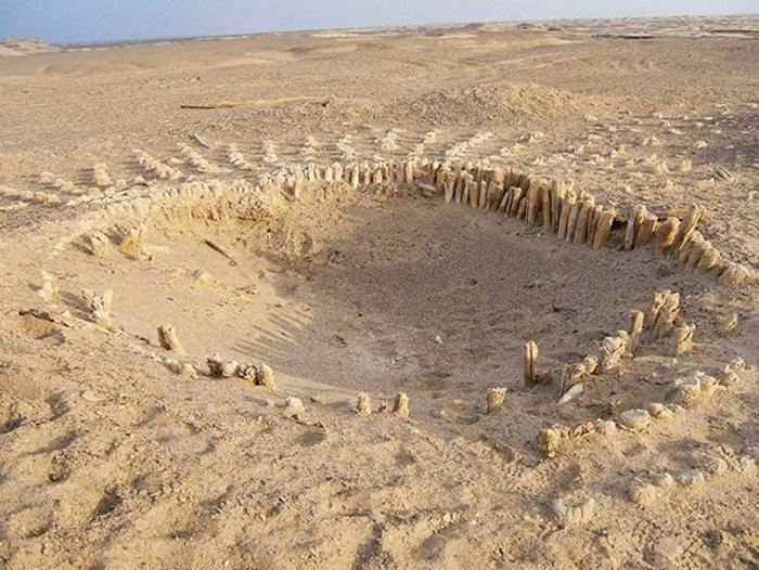
Xiaohe Burial Site
The Xiaohe Tomb complex is located to the west of Lop Nur. This bronze-age burial site is an oblong sand dune, from which more than thirty well preserved mummies have been excavated. The entire Xiaohe Tomb complex contains about 330 tombs, about 160 of which have been violated by grave robbers. A local hunter guided the Swedish explorer and archeologist Folke Bergman to the site in 1934. An excavation project by the Xinjiang Cultural Relics and Archaeology Institute began in October 2003. A total of 167 tombs have been dug up since the end of 2002 and excavations have revealed hundreds of smaller tombs built in layers, as well as other precious artifacts. In 2006, a valuable archeological finding was uncovered: a boat-shaped coffin wrapped in ox hide, containing the mummified body of a young woman.
Qäwrighul
In 1979, some of the earliest of the Tarim mummies were discovered in burial sites at Qäwrighul (Gumugou), which is located to the west of Lop Nur, on the Könchi (Kongque) river. Forty-two graves, most of which dated from 2100-1500 BC, were found. There were two types of tomb at the site, belonging to two different time periods. The first type of burial featured shaft pit graves, some of which had poles at either end to mark east and west. Bodies were found extended, usually facing east, and sometimes were wrapped in wool weavings and wearing felt hats. Artefacts found included basketry, wheat grains, cattle and sheep/goat horns, bird bone necklaces and bracelets, nephrite beads, and fragments of copper (or bronze), although no pottery was discovered.
The second type of burial, from a later period, also consisted of shaft pit graves, surrounded by seven concentric circles of poles. Six male graves were found, in which the bodies were extended on their backs, and facing towards the east. Few artifacts were found, except for some traces of copper, or bronze.
Miran
Miran is located to the south-west of Lop Nur. Buddhist monasteries were excavated here, and murals and sculptures showed artistic influences form India and Central Asia, with some showing influences from as far as Rome.