
- location Qilian Shan, Qinghai - elevation 789 m (2,589 ft) Discharge 28.8 m³/s Province Gansu Country China | - elevation 5,000 m (16,404 ft) Length 905 km Basin area 102,300 km² Mouth Lop Nur | |
 | ||
- left Lucao River, Dang River - location Kumtag Desert, Xinjiang - average 28.8 m/s (1,017 cu ft/s) | ||
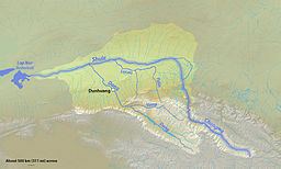
The Shule River flows generally westwards through the Tibetan Plateau and the desert regions of northwestern China. It starts in the Qilian Mountains and stretches for some 900 kilometres (560 mi); however, the river dries up about two-thirds of the way along its course and is lost in the Kumtag Desert, an endorheic basin, meaning its water never reaches the sea. Historically, the river reached farther west to Lop Nur, an intermittent salt lake in the Taklimakan Desert. Large irrigation diversions off the river and the gradual desertification of the region have reduced its flow significantly.
Contents
Map of Shule River, Dunhuang, Jiuquan, China
CourseEdit
It rises as several streams in a valley on the northern side of the Qilian Mountains or Nan Shan, on the Tibetan Plateau of extreme northern Qinghai province. In its upper 310 kilometres (190 mi) the river flows generally NNW through deep, glacier-carved valleys and precipitous gorges into Gansu Province, and is known as the Changma. It comes out of the mountains in Guazhou County, and spreads onto a massive inland delta or alluvial fan. Now known as the Shule proper, the river turns due west into an agricultural valley, where most of its water is taken away for irrigation and industrial use. North of Dunhuang, the largest city in the river's basin, it disappears into the desert, after flowing some 540 kilometres (340 mi). The dry river channel stretches about 350 kilometres (220 mi) further WSW to the seasonal Lop Nur basin, which comprises intermittent salt flats, playas and marshes.
GeographyEdit
The Shule's drainage basin covers about 102,300 square kilometres (39,500 sq mi) of land, but the contributing portions total only 20,197 square kilometres (7,798 sq mi). There are many other valleys and basins that would drain into the river during extreme floods, but because of the aridity of the region, high flow events are rare. The average precipitation in the watershed is 200 to 300 millimetres (7.9 to 11.8 in) per year. In the high mountain areas it can be up to 800 millimetres (31 in), mostly in the form of snow. In the deserts to the north annual precipitation is usually below 100 millimetres (3.9 in) and in some years, no rain falls at all.
Most of the Shule's water arises from glaciers. There are 347 glaciers in the upstream catchment area of the river encompassing a total area of 29.45 square kilometres (11.37 sq mi). The annual runoff is approximately 1,083,000,000 cubic metres (878,000 acre·ft), ranging from 536,000,000 cubic metres (435,000 acre·ft) in dry years to 1,507,000,000 cubic metres (1,222,000 acre·ft) in wet years. Because of a general warming trend in the region, the glaciers feeding the river could eventually melt completely, causing it to dry up.
River modificationsEdit
The river valley is intensely cultivated and its flow is regulated by two reservoirs, Changma and Shuangta. There are also more than three additional hydropower/diversion dams on the river. The entire flow of the Shule is diverted directly downstream of the mountains into a canal that runs north-northeast across the delta, supplying farms in the valley to the north. This water is eventually returned to the river, but irrigation usage has caused the river to dry up well before its historic terminus. It is surmised that a few thousand years ago, the region was cooler and wetter, and the river had significantly more flow than it does today.