
Established 1986 | ||
 | ||
Area 6,700,000 ha (67,000 km) Governing body State Environment Protection Administration of China (SEPA) | ||
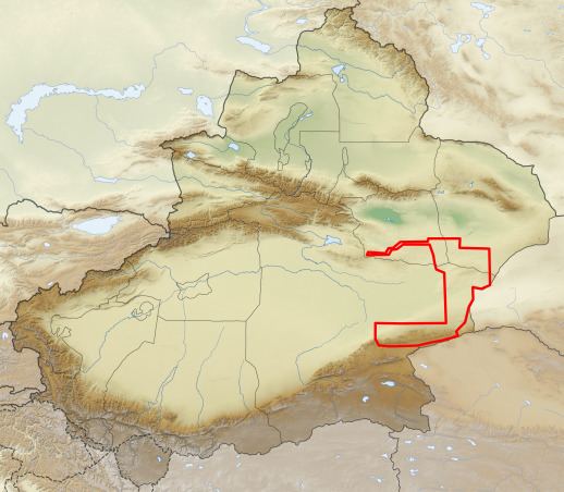
Lop Nur Wild Camel National Nature Reserve (simplified Chinese: 罗布泊野骆驼自然保护区综合; traditional Chinese: 羅布泊野駱駝自然保護區綜合) protects one of the three remaining habitats of the Wild Bactrian camel (Camelus ferus), a critically endangered species. The reserve stretches around the north, east, and south of Lop Nur, a dry lake in a desert known as the "Sea of Death", and one of the most arid regions in the world. The reserve was established in 1986 by Xinjiang Province, and has been modified over the years. The reserve is under pressure from new new roads in the area, development of mining interests, and illegal hunting. The area was formerly used as China's nuclear test site.
Contents
Topography
The reserve is situated in an uninhabited, arid desert of mountains and valleys. The Tarim Basin is to the west, the Altyn-Tagh mountains form a southern barrier, and the Karum Tagh range (an extension of the Tien Shan) mountains are to the north. A corridor of sand dunes run north-south on the eastern edge of the site, protecting the camels from eastern influences, as does the dry lake bed of Lop Nur to the west. The Altun Shan National Nature Reserve borders Lop Nur to the southwest.
Climate and ecoregion
The climate of the reserve has been described as "hostile". Extreme aridity, extreme heat in summer, extreme cold in winter, and abrasive sandstorms create an environment that few plants or animals are adapted to survive. The climate classification is Cold desert climate" (Köppen climate classification "BWk" ). Parts of the area receive an average of only 10–20 mm of precipitation per year, with an average 4,000 mm/year evaporation.
The Lop Nur Reserve is in the east of the Taklamakan Desert ecoregion. Because this region is surrounded by mountains, it is cut off from the Asian monsoon and from Arctic air masses. The result is one of the driest place on earth.
Flora and fauna
Due to the aridity and salinity of the soil, vegetation cover is sparse, varying from 6% in the Kuruk Tagh mountains, up to 30% on flood plains of the Airgin mountains in the south. Halophytes predominate. The north slope of the Arjin Mountains in the south, and the Aqike Valley below, have more vegetation cover and provide the best habitat for the wild camels.
The wild camel population of the reserve was estimated at 638 in 2013. Virtually all of them are found in the southeastern third of the area, although they do roam outside the boundaries. The Aqike Valley appears to be the prime breeding ground, as it benefits from more extensive vegetation, snow melt from the mountains, and an underground water table that approaches 2 meters from the surface. The camels have adapted to drinking the salt water of the desert.
Reserve management
In recent years, professional management has been brought to the reserve, with patrols and guard checkpoints, scientific surveys, public education initiatives, and has channeled water from the mountains to prime breeding areas. The population of wild camels appears to be recovering. Poaching is recorded as on the decline, and there are no domesticated camels in the reserve.