
Prominence 2,344 m (7,690 ft) Last eruption May 1877 Listing Ultra-prominent peak | Mountain type Stratovolcano | |
 | ||
Elevation 6,723 or 6,739 m (22,057 or 22,110 ft) Similar | ||
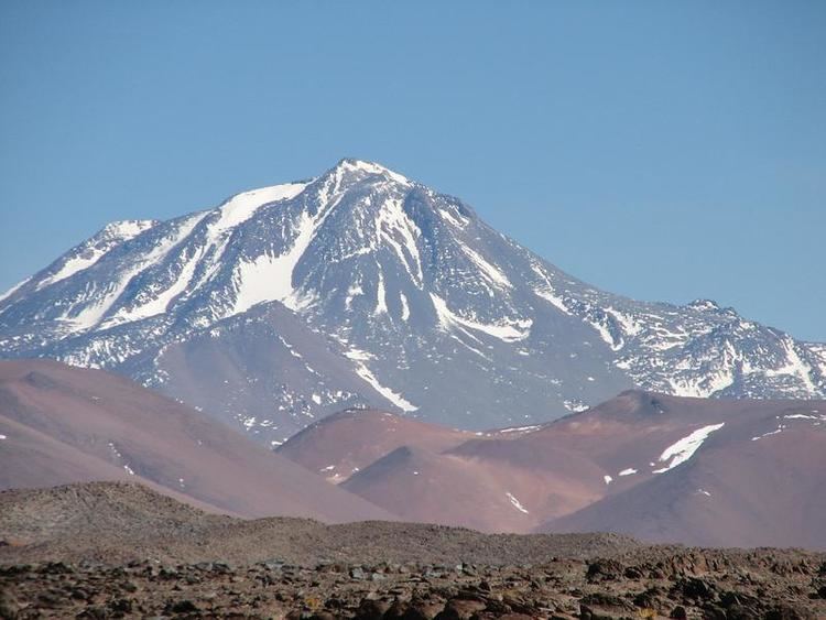
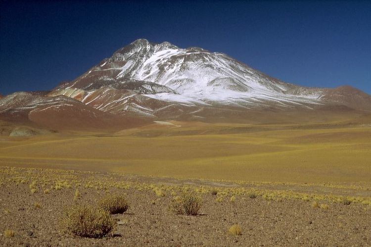
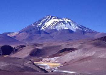
Llullaillaco ([ʝu.ʝai̯.ˈʝa.ko]) is a dormant stratovolcano at the border of Argentina (Salta Province) and Chile (Antofagasta Region). It lies in the Puna de Atacama, a region of very high volcanic peaks on a high plateau close to the Atacama Desert, one of the driest places in the world. It is the second highest active volcano in the world after Ojos del Salado.
Contents
- Name
- Geography and geology
- Local setting
- The volcano
- Debris avalanche
- Basement
- Composition
- Geological history
- Climate glaciers and biota
- Archeology
- Eruptive history
- References
Llullaillaco was constructed during two different phases in the Pleistocene-Holocene by dacitic lava flows. The oldest rocks are about 1.5 million years old. About 150,000 years ago, the volcano's southeastern flank collapsed and generated a debris avalanche that reached as far as 25 kilometres (16 mi) from the summit. The youngest dated rocks were erupted 5,600 ± 250 years ago in the summit region, but there are reports of activity from the 19th century.
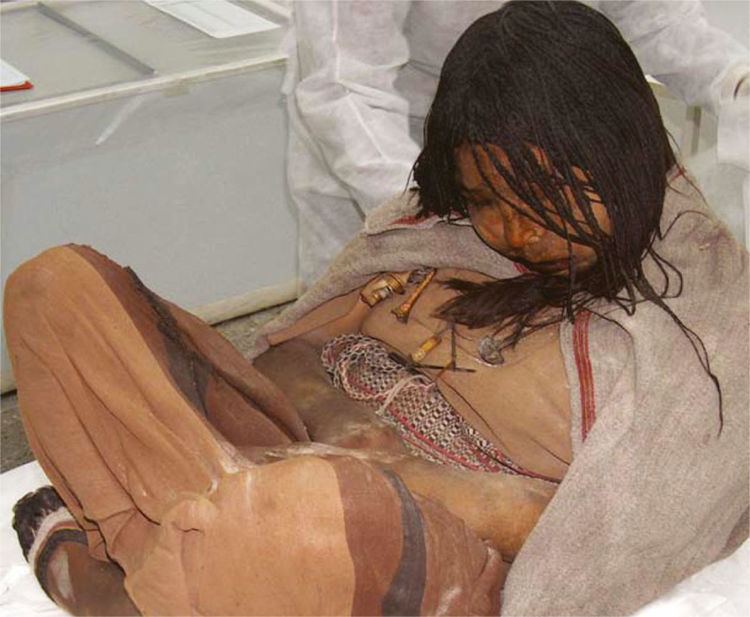
The mountain's first recorded climb was in 1950, but traces of earlier climbs, and a number of archeological sites, were found on the mountain and at its feet. With an archeological site at the summit region, Llullaillaco is the highest archeological site in the world. There, in 1999, the mummified remains of three children, known as the Children of Llullaillaco, were found. They are presumed to have been human sacrifices.
Name
The name Llullaillaco is derived from the Kunza word llulla meaning "false", "lie" or "deceitful" and yaku or llaco meaning "water". This name probably refers to the meltwater from snow, which flows down the slopes but then is absorbed into the soil. Normally such mountains are sources for water.
Geography and geology
Volcanism in the Andes is caused by the subduction of the Nazca Plate and the Antarctic Plate beneath the South America Plate. The Nazca Plate subducts at a speed of 7–9 centimetres per year (2.8–3.5 in/year) and the Antarctic Plate at a speed of 2 centimetres per year (0.79 in/year). Volcanism does not occur along a continuous chain; there are four separate regions named: the Northern Volcanic Zone, the Central Volcanic Zone, the Southern Volcanic Zone, and the Austral Volcanic Zone. The formation of magma results from the release of water and other volatile material from the subducting plate, which is then injected into the above-lying mantle wedge. The volcanic zones are separated by areas where the subducting plate subducts at a flatter angle and volcanism is absent. The Peruvian flat slab between the Northern and the Central Volcanic Zones is associated with the subduction of the Nazca Ridge, the Pampean flat slab between the Central and the Southern Volcanic Zone is associated with the subduction of the Juan Fernandez Ridge, and the Patagonian volcanic gap between the Southern and the Austral Volcanic Zone is associated with the Chile Triple Junction.
About 178 volcanoes are found in the Andes, 60 of which have been active in historical times. In addition, large calderas and monogenetic volcanoes exist in the Andes.
Local setting
Llullaillaco is part of the Central Volcanic Zone. At least 44 volcanic centres with historical activity and 18 large caldera-forming volcanoes have been identified in the Central Volcanic Zone. Volcanism in the Central Volcanic Zone mostly occurs on the Altiplano and the Cordillera Occidental. A number of volcanoes there reach heights of over 6,000 metres (20,000 ft) above sea level. Large Miocene ignimbrites that cover large surfaces are also part of the regional geology. Llullaillaco is located about 300 kilometres (190 mi) east of the Peru-Chile Trench. The Wadati-Benioff zone is 180 kilometres (110 mi) deep.
Llullaillaco is located in the northwestern Argentine Andes, towards the southern end of the Puna. The border between Argentina (Salta Province) and Chile crosses the volcano. It lies in the Puna de Atacama, a region of very high volcanic peaks on a high plateau close to the Atacama Desert, one of the driest places in the world.
The volcano is an imposing mountain, rising by 3,800 metres (12,500 ft) above the Salar de Punta Negra 36 kilometres (22 mi) away. With a summit height of 6,723 metres (22,057 ft), or alternatively 6,739 metres (22,110 ft), it is the second highest active volcano in the world after Ojos del Salado (6,887 metres (22,595 ft), 27°07′S 68°33′W). The height of the mountain and the clear air in the region make Llullaillaco visible from Cerro Paranal. The region is dry and located at high altitudes, making work in the area difficult.
17 kilometres (11 mi) farther east of Llullaillaco lies the Miocene Cerro Rosado volcano (5,383 metres (17,661 ft)). This volcano has erupted dacitic lava flows during the Pliocene-Quaternary on its northeastern and southern flanks. 20 kilometres (12 mi) east of Llullaillaco, and behind Cerro Rosado, lies the Salar de Llullaillaco (3,750 metres (12,300 ft) ), a salt pan with warm springs at its western and southwestern shores and three abandoned borate mines: Mina Amalia and the salt mines Mina Luisa and Mina Maria. Mitral mountain (5,015 metres (16,453 ft)) lies southwest of Llullaillaco and is of Miocene age. It features an eroded crater that opens to the northwest. Iris mountain (5,461 metres (17,917 ft)) north of Llullaillaco is constructed of Pliocene rocks. Other volcanoes in the neighbourhood are Dos Naciones, Cerro Silla, and Cerro 5074.
The volcano
Llullaillaco is a stratovolcano which rises 2,200 metres (7,200 ft) above the surrounding terrain. The edifice has an elliptical shape with dimensions of 23 by 17 kilometres (14 mi × 11 mi) and has a volume of about 50 cubic kilometres (12 cu mi). It is formed by thick dacitic lava flows erupted during the Quaternary. These flows extend away from the volcano and form its summit. An older unit is formed by ignimbrites and pyroclastic flows. Older lava flows extend west from the volcano and are partly buried by sediments closer to the edifice. These flows reach lengths of 20 kilometres (12 mi) and form about 70% of the surface of the volcano.
The slopes of the volcano are fairly steep, with an altitude drop of 1,800 metres (5,900 ft) over only 3 kilometres (1.9 mi) horizontal distance. The slopes high up are steeper than those at lower altitudes. A crater at 6,100 metres (20,000 ft) altitude was formed early in the development of the Llullaillaco volcano. Erosion has reduced it to a plateau. This crater is filled with snow and ice. The ice shows evidence of recent geothermal heating.
The summit of Llullaillaco is formed by a small cone with about four associated lava domes, which reach lengths of 1–3 kilometres (0.62–1.86 mi) and have abrupt walls. Large dacitic coulees emanate from the summit of the volcano and are young in appearance. One extends north of the volcano and the other one south. Their overall length is 4.5–8 kilometres (2.8–5.0 mi) and their flow fronts are up to 15 metres (49 ft) thick. Morphologically, these flows are reddish-black aa lava flows and feature blocks with sizes of 5 metres (16 ft). The southern lava flow is 6 kilometres (3.7 mi) long and was fairly viscous when it was erupted. It almost reaches a road southwest of the volcano. These flows feature levees and ridges. At first they were considered to be Holocene, but argon-argon dating indicates they are of late Pleistocene age. Some traces of glacier activity are found in the summit area.
At least two stages of construction are recognized, Llullaillaco I and Llullaillaco II. The first stage originated from two centres and is now extensively degraded by glaciation and hydrothermal alteration. This applies especially to the 5,561 metres (18,245 ft) high Azufrera Esperanto mountain 5 kilometres (3.1 mi) north of Llullaillaco, where little original volcanic substance is preserved and where erosion has exposed deeply altered white rock. Llullaillaco II on the southern and northeastern flank is better preserved; the toes of the lava flows reach thicknesses of 500 metres (1,600 ft). Its lava flows are less extensive than the ones of Llullaillaco I. Pyroclastic flow deposits with a composition similar to Llullaillaco II are found on the southern slope of the volcano and may have formed before the lava eruptions began.
Volcanism in the Central Volcanic Zone may be affected by deep-seated lineaments, which control where volcanoes and geothermal systems form. Such lineaments extend diagonally across the volcanic arc and are accompanied by volcanic manifestations at substantial distances from the arc. One of these lineaments, the Archibarca, runs beneath Llullaillaco and is also associated with the Escondida copper deposit, and the Llullaillaco, Corrida de Cori, Archibarca, Antofalla, and the Galán caldera. Other lineaments include the Calama-El Toro.
Several dry valleys originate on Llullaillaco, including Quebrada de las Zorritas on the north-northeastern slope, Quebrada El Salado and Quebrada Llullaillaco on the northwestern slope, and Quebrada La Barda on the southwestern slope. The Quebrada Llullaillaco drains into the Salar de Punta Negra northwest of the volcano. The volcano is relatively unaffected by water erosion.
Periglacial phenomena are observed on Llullaillaco, commencing at 4,300 metres (14,100 ft) altitude and reaching their maximum around 5,100–5,400 metres (16,700–17,700 ft) on the Chilean and 5,350–5,700 metres (17,550–18,700 ft) on the Argentine side. There, solifluction and cryoplanation surfaces are developed, including lobe-shaped ground and block ramparts. These landforms have been mapped on the northwestern side of the volcano. Patterned ground is also common. Permafrost is found at higher altitudes. Cryoplanation and solifluction landforms are also observed on Iris and Mitral. Other than on periglacially influenced terrain, the ground at Llullaillaco is formed mostly by lavic rocks and block debris, which are frequently buried by tephra.
Two abandoned sulfur mines can be found north and south of Llullaillaco. The northern mine is known as Azufrera Esperanto and associated with an area of hydrothermal alteration. A path or road leads up to that mine from northwest.
Debris avalanche
A major landslide occurred in the volcano's history during the late Pleistocene, probably triggered by volcanic activity. This landslide descended the eastern-southeastern flanks of the volcano into Argentina, first over a steep slope of 20° on the volcano, split around Cerro Rosado and entered the Salina de Llullaillaco 25 kilometres (16 mi) east of the summit, extending up to 5 kilometres (3.1 mi) into the salar. The toe of the avalanche reaches a thickness of 10 metres (33 ft) above the salar in the avalanche's southern lobe. Part of the avalanche was channelled in a valley between Cerro Rosado and an unnamed volcano farther south. When it reached Cerro Rosado, the avalanche climbed about 400 metres (1,300 ft) and mostly continued to flow southeast into the main avalanche path, with only a small flow continuing northeastwards. Part of the run-up avalanche later collapsed backwards over the main avalanche deposit. Unlike Socompa farther north, a landslide scar is only poorly developed at Llullaillaco despite the large size of the collapse; it was largely filled in later by lava flows and volcaniclastic debris.
This landslide has been subdivided into four facies and features landforms like levees up to 50 metres (160 ft) high, longitudinal ridges and a run-up mark on Cerro Rosado. Such ridges may be associated with uneven underlying terrain. The surface of the slide is covered by lava bombs less than 1 metre (3 ft 3 in) long, blocks exceeding 2 metres (6 ft 7 in) width, cobbles, and gravel-like rocks. Close to the collapse scarp on Llullaillaco the largest blocks with sizes of up to 20 metres (66 ft) are found. Overall, the margins of the landslide are very crisp and the surface covered by hummocks.
The landslide deposit covers a surface of about 165 square kilometres (64 sq mi). Its volume has been estimated at 1–2 cubic kilometres (0.24–0.48 cu mi) and the speed at 45–90 metres per second (150–300 ft/s). This speed range is comparable to that of the Colima, Lastarria, and Mount St. Helens debris avalanches. The landslide occurred no later than 156,000 – 148,000 ± 5,000 years ago, it might coincide with the 48,000 year old lava flow. Some volcanic rocks were still hot at the time of the collapse, indicating that volcanic activity occurred immediately before the collapse. A smaller undated avalanche occurred on the northeastern flank.
Such landslides are common at volcanoes, where they are favoured by the steep edifices that form from lava flows being stacked on top of each other. It is not usually known what triggers the collapse, although eruption-associated earthquakes are suspected to play a role. Other volcanoes in the region with sector collapses are: Lastarria, Ollague, San Pedro, Socompa, and Tata Sabaya. The Mellado and Cerro Rosado volcanoes close to Llullaillaco also display evidence of sector collapses.
Basement
The terrain around Llullaillaco consists of andesite and dacite lavas and pyroclastics of Miocene to Pliocene age. Some Oligocene-Miocene layers are exposed in the Quebrada de las Zorritas. Dates obtained by argon-argon dating range between 11.94 ± 0.13 and 5.48 ± 0.07 million years ago. 15 kilometres (9.3 mi) west of Llullaillaco do Paleozoic granites and volcanites crop out. Elsewhere these layers are buried by Cenozoic rocks.
Composition
Llullaillaco has mostly erupted dacites with medium potassium content, with rocks becoming more felsic the younger they are. Rock samples taken from Llullaillaco are mostly porphyritic or vitrophyric, with a glassy or microcrystalline matrix. Phenocrysts are mostly plagioclase, with mafic phenocrysts being dominated by orthopyroxene and smaller amounts of biotite, clinopyroxene, and hornblende. Ilmenite, magnetite, and sulfide minerals are also present, magnetite especially in the more oxidized older lavas. Some phenocrysts show evidence of a complex history. Quartz is rare. Older lavas have developed a red colour and contain oxidized iron in form of hematite. Lavas from Llullaillaco I are grey. The content of SiO
2 is 65–67%.
The rocks belong to the calc-alkaline series. Trace element data are typical for Central Volcanic Zone rocks. High potassium content is typical for shoshonite-like lavas erupted at large distance from the trenches.
The composition may reflect magma differentiation in a solitary magma chamber, but with occasional replenisment with more primitive magma. Magma mixing and plagioclase crystallization occurred in it. A lithospheric structure probably directed magma flows over long time periods along the same pathway. The depth of the magma source probably varied over the history of the volcano. The total magma output at Llullaillaco is about 0.05 cubic kilometres per millennium (0.00038 cu mi/Gs).
Geological history
Research by J.P. Richards and M. Villeneuve has allowed the determination of the geological history of the region. Had volcanism during the Eocene and Oligocene been centered on the Precordillera, increased subduction of the Nazca Plate during the late Oligocene caused the volcanic arc to broaden to about 250 kilometres (160 mi). 25 million years ago, the "Quechua event" triggered the uplift of the Puna-Altiplano, a highland covering a surface area of 500,000 square kilometres (190,000 sq mi) and reaching an altitude of 3,700 metres (12,100 ft). In the late Miocene-Pliocene a phase of strong ignimbrite volcanism occurred. About 2 million years ago, the "Diaguita deformation" was characterized by a change in the deformation regimen from crustal shortening to strike-slip faulting and of volcanism from voluminous felsic eruptions to isolated stratovolcanoes and back-arc mafic volcanism. A slowdown in the subduction may have caused this change. Nowadays most volcanism occurs at the western edge of the Puna, where volcanoes such as Lascar and Llullaillaco formed.
Climate, glaciers and biota
The climate at Llullaillaco is cold and dry. The average temperature is about −13 °C (9 °F), with temperature maximums ranging −8 – −13 °C (18–9 °F) between summer and winter. Ground temperatures however can reach 12.5 °C (54.5 °F) during the day in summer. The temperature of the ground fluctuates strongly during the day. The climate is extremely sunny on account of the lack of a cloud cover, the high altitude, and the close coincidence between summer solstice with the day where Earth is closest to the Sun. Snowfall can occur down to altitudes of 4,000 metres (13,000 ft). Precipitation is episodic to the point that it is difficult to give average values. It is most often associated with either convective or cyclonic activity during summer and winter respectively.
Small glaciers are found above 6,000 metres (20,000 ft) altitude. Other sources contend there are no glaciers on Llullaillaco, which would make it the highest mountain in the world without one; although the existence of an ice slab on the western slope was reported in 1958. However, Llullaillaco has snow fields. Firn and penitentes cover large surfaces above that altitude, especially in more sheltered areas. 1 metre (3 ft 3 in) high penitentes were observed in 1954. Snow covers the terrain above 5,400–5,800 metres (17,700–19,000 ft) altitude. Gullies that are found in the area probably result from meltwater runoff. The snowfields on Llullaillaco supply water to the Salar de Punta Negra.
The existence of a cirque on the northwestern slope has been postulated. It was once believed that Llullaillaco had experienced three large glaciations, but the "moraines" are actually mudflow deposits. However, during the Pleistocene glaciers reached down to 5,100 metres (16,700 ft) altitude on the northwestern slope. Lava flows have overrun some of the glaciated surfaces and it is possible that lava flows induced the melting of glaciers. A number of glacial landforms elsewhere were destroyed by mudflows during the time of Llullaillaco's last activity. Llullaillaco may not have been glaciated at all during the Pleistocene.
Between 24 and 25° degrees southern latitude the Andean Dry Diagonal crosses the Andes. At this latitude, half of the precipitation falls in summer and the other half in winter. The formation of this dry diagonal is an effect both of the rainshadow effect of the Andes, air subsidence within South Pacific High, and the cold Humboldt Current off the Pacific coast. This is the reason why the Atacama Desert exists. The extremely arid climate at Llullaillaco is also a consequence of these climatic effects.
Vegetation is scarce in the arid climate. Vegetation at Llullaillaco begins at 3,700–3,800 metres (12,100–12,500 ft) altitude with Acantholippia punensis, Atriplex imbricata, and Cristaria andicola. They are joined at 3,900 metres (12,800 ft) altitude by Stipa frigida which can be found up to 4,910 metres (16,110 ft) of altitude. The maximum vegetation density is found around 4,250 metres (13,940 ft) with 12% of the surface and decreases thereafter, probably due to the low temperatures. At this altitude, Adesmia spinosissima, Fabiana bryoides, Mulinum crassifolium, and Parastrephia quadrangularis are found in addition to the previously mentioned plants. Weakly developed bacterial communities have been found in the soils at Llullaillaco; some may depend on volcanic carbon monoxide.
Dry valleys and sheltered areas feature grasses. A permanent spring is found in Quebrada de las Zorritas. Deposits in this valley indicate that between 2,436.8 ± 49 and 1,593.1 ± 36 radiocarbon years ago runoff was more intense.
Archeology
In 1999, a team of archeologists found three mummies of children on the top of Llullaillaco. At the time of their death they were six, seven, and fifteen years old. They were ostensibly human sacrifices offered to the gods of the Inka pantheon on mountaintops. In 2003 they were at the Catholic University of Salta, but starting from 2007 they can be found at the Museum of High Altitude Archaeology of Argentina.
The mummies were found buried 1.7 metres (5 ft 7 in) beneath a 11 by 6 metres (36 ft × 20 ft) large platform. The existence of ruins in the summit area had been reported during the first climb of the volcano in 1950.
Other archeological objects found along with the mummies included: headdresses with feathers, pottery, statues made out of gold and silver and textiles. A total of 145 objects were found together with the mummies.
At least three paths lead up to Llullaillaco. Two of them meet at a tambo or inn at an altitude of 5,200 metres (17,100 ft), while the third passes through a cementerio (cemetery) where 16 bodies were found in 1972 before reaching the tambo. From the tambo another path leads up the mountain, past two further archeological sites to 6,000 metres (20,000 ft) of altitude. At this altitude the path is marked by cairns, probably to indicate where the path is when the volcano is covered by snow. The path ends at 6,500 metres (21,300 ft) altitude at the Portezuelo de Inka ruins, where a staircase begins. From these ruins one path goes to a cemetery at 6,715 metres (22,031 ft) altitude and another to the summit platform. The other path reaches two subrectangular walls 20 metres (66 ft) farther up, and continues to the platform where the mummies were found. These are the highest archeological sites in the world. The paths were discovered by Mark Rebitsch in 1958.
Llullaillaco appears to have been the most important Inca sacred mountain in the region. Archeological sites are also found in the valleys that drain Llullaillaco towards the Salar de Punta Negra, including the Quebrada Llullaillaco and the Quebrada de las Zorritas. The paths connect with the major north-south axis that runs between San Pedro de Atacama and Copiapo. This axis is associated with the extensive Inca road system.
Eruptive history
Llullaillaco I is of early Pleistocene age. The oldest date, 1.5 ± 0.4 million years ago, was determined on a lava flow northwest of Llullaillaco's main edifice. Two dates obtained on lava flows of Llullaillaco II are 401,000 ± 6,000 and 1,500,000 ± 400,000 years ago, based on argon-argon dating and potassium-argon dating respectively. Surface exposure dating based on helium has yielded ages of 41,000 ± 1,000 years for Llullaillaco I at over 5,000 metres (16,000 ft) altitude and of 5,600 ± 250 years for Llullaillaco II at an altitude of over 6,000 metres (20,000 ft).
The northern young lava flow is less than one million years old based on potassium-argon dating, the southern flow is 48,000 ± 12,000 years old based on argon-argon dating on biotite.
Llullaillaco has been active in historical time, with the last eruption occurring in the late 19th century. Eruptions were recorded in February 1854, September 1868, and May 1877, involving two explosive eruptions and one with lava flows. According to a report in 1899, during the 1868 eruption large fissures opened on its slopes. The last eruption consisted of smoking reported at the time of the 1877 Iquique earthquake.
The volcanos is currently considered dormant. Future eruptive activity may cause sector collapses, although they would be a small danger to human life, given that the area is sparsely inhabitated.