
Elevation 5,706 m (18,720 ft) Volcanic belt Central Volcanic Zone | ||
 | ||
Mountain type Andesitic-dacitic volcano | ||
Lastarria is a volcano that lies on the border between Chile and Argentina. It is part of the Central Volcanic Zone, one of the four segments of the volcanic arc of the Andes. Several volcanoes are located in this chain of volcanoes, which is formed by subduction of the Nazca Plate beneath the South American Plate.
Contents
- Map of JosC3A9 Victorino Lastarria Santiago RegiC3B3n Metropolitana Chile
- Geography and structure
- Edifice proper
- Landslide scar
- Sulfur
- Internal structure
- Geology
- Local
- Geologic record
- Composition
- Climate and vegetation
- Eruptive history
- Fumarolic activity
- Ground uplift
- Threats
- References
Map of Jos%C3%A9 Victorino Lastarria, Santiago, Regi%C3%B3n Metropolitana, Chile
Lastarria is formed by two volcanic edifices and one subsidiary lava flow field. There is no recorded eruptive activity, but the volcano displays vigorous fumarolic activity. It is located on top of older volcanic rocks and features both andesite and dacite.
Lastarria has produced a large landslide deposit as well as flows of molten sulfur. A progressive uplift of the terrain around Lastarria and farther south has been recognized.
Geography and structure
Lastarria is situated in the Central Andes, in the Antofagasta Region of Chile, and straddles the border with Argentina. The city of Antofagasta lies 250 kilometres (160 mi) northwest of Lastarria. The area of the Central Andes is difficult to access and its volcanoes are usually poorly monitored. There are no human populations within 150 kilometres (93 mi) of Lastarria. From the former Catalina railway station 120 kilometres (75 mi) west, an unpaved road leads to Lastarria.
Lastarria is part of the Andean Central Volcanic Zone, which extends over 1,500 kilometres (930 mi) from Peru to Chile. Over 1,000 volcanic edifices have been identified in this zone, of which about 50 volcanoes are active or potentially active, with many exceeding 6,000 metres (20,000 ft) in altitude. In addition, the zone features 18 monogenetic volcanoes and about 6 caldera/ignimbrite systems.
Edifice proper
Lastarria is formed by two coalesced edifices, the main cone and the older South Spur (Espolón Sur), which are joined at an altitude of about 5,500 metres (18,000 ft) and form a 10-kilometre (6.2 mi) long ridge. The main cone comprises lava domes, lava flows, pyroclastic flows, and scoria, with most of the volcano covered by pyroclastic material, some of which extends to the southeastern margin of the Salar de Aguas Calientes. Lava flows are exposed mainly on the northwestern slope, where they reach thicknesses of 40 metres (130 ft). The South Spur has also generated lava flows. The volcano covers a surface area of about 156 square kilometres (60 sq mi).
Five overlapping craters are aligned in a north-south line on Lastarria's main cone. Volcanic activity has migrated north during the history of Lastarria, and the most recent eruption products are found on the northern and western slopes. A lava dome sits on the northernmost crater rim. The South Spur has two craters.
The volcano rises from a terrain of about 4,200 metres (13,800 ft) altitude and has fairly steep slopes. Much of the surface, including the Southern Spur, is covered by deposits left by ash fall. Some parts of the Southern Spur display evidence of hydrothermal alteration. The total volume of the edifice is about 10.1 cubic kilometres (2.4 cu mi).
The Negriales del Lastarria (also known as Big Joe) lava flow complex lies southwest of the Lastarria volcano and covers an extensive surface. It is formed by several massive flows erupted from a single vent during three or eight pulses; the longest reaches a length of 10 kilometres (6.2 mi). These lavas are block lavas with flow ridges and levees. The total volume of the lava field is about 5.4 cubic kilometres (1.3 cu mi).
Neighbouring mountains include the 4,709-metre (15,449 ft) high Cerro Bayo northwest and the 5,214-metre (17,106 ft) high Cerro Piramide close to Negriales de Lastarria in the southwest. Almost due north of Lastarria lies the Laguna de la Azufrera, which may be a source of water for the fumarolic system. Water levels in the lake were higher in the past, as evidenced by two recognizable shorelines.
Landslide scar
A major sector collapse occurred on Lastarria's southeastern flank, leaving a clearly defined north-south scarp in the volcano that opens to the east-southeast. On the northern side, this scarp is 65 metres (213 ft) high; it becomes less pronounced at its southern end. The highest point of the scarp lies at an altitude of 5,575 metres (18,291 ft).
The debris avalanche deposit is 8 kilometres (5.0 mi) long and well preserved. After exiting the collapse scar over its northern opening, it overrode an older scoria cone before coming to rest. The slide, bordered by levee-like structures reaching a height of 20 metres (66 ft), formed 500-metre (1,600 ft) wide and 40-metre (130 ft) high lobes. Unlike many debris avalanche deposits, the Lastarria debris avalanche lacks large blocks and has only a few hummocks. The velocity of the avalanche has been estimated to have been over 84 metres per second (280 ft/s), a fairly high velocity for a volcanic debris avalanche. It is possible that air was entrained in the debris, which thus assumed properties similar to an ignimbrite.
The avalanche deposit consists mostly of loose material such as ash, lapilli, pumice, with only a few lithic blocks. This loose consistency may explain the lack of megablocks. Its total volume is about 0.091 cubic kilometres (0.022 cu mi), less than the volume of the Mount St. Helens and Socompa deposits. It is comparable to the volume of the landslide that the Ancash earthquake triggered on Huascarán in Peru in 1970, resulting in more than 20,000 fatalities. Evidence points to previous flank collapses at Lastarria.
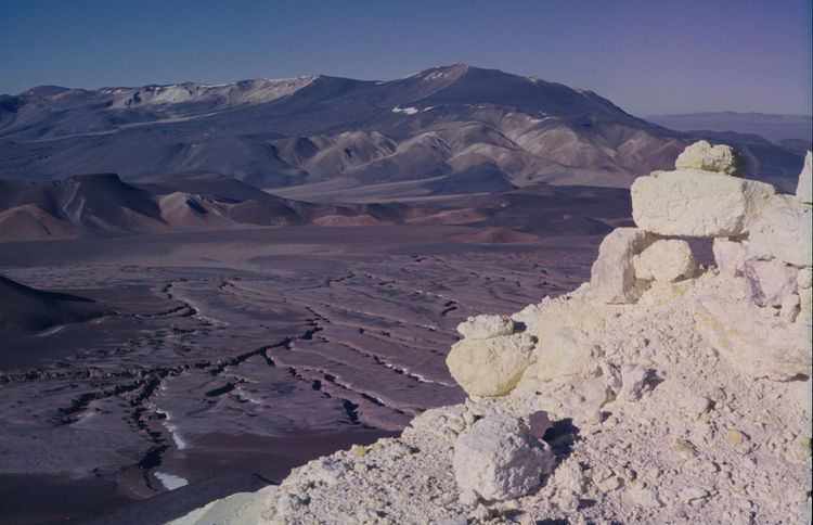
Sulfur
The fumaroles on Lastarria have created widespread deposits of sulfur. The sulfur has also formed flows, of which the two largest are 350 metres (1,150 ft) and 250 metres (820 ft) long. The longer flow is partly buried by the shorter one and has already lost part of its surface structure. No vents have been found; sulfur flows appear to emerge from the fumarolic terrain. One andesite lava flow has generated several subsidiary sulfur flows that resemble pahoehoe flows and have widths of 1 to 2.5 metres (3 ft 3 in to 8 ft 2 in). It is likely that sulfur deposited by fumaroles formed such flows. Some fumaroles currently release centimetre-long sulfur flows. Flows of sulfur are highly fragile constructs that can easily be destroyed.
The conditions surrounding the emplacement of the sulfur have caused the sulfur to assume various colours, including black, brown-orange, orange, red, yellow, and yellow-orange. These colours vary along the length of the flows and between various flows, indicating that temperatures varied between one flow and another. Liquid sulfur has different viscosity and rheomorphic properties at different temperatures, and some variation occurred at Lastarria's flows as well.
Such sulfur flows are rare on Earth; they may be more common on the Jupiter moon Io. On Earth, they have been found at Kawah Ijen in Indonesia, Mount Iō (Shiretoko) in Japan, Mauna Loa on Hawaii, Momotombo in Nicaragua, and Sierra Negra on the Galapagos Islands.
Internal structure
The internal structure of a volcano can be visualized with a technique known as seismic wave tomography. An inverted funnel-shaped low velocity anomaly with a width of 4 by 9 kilometres (2.5 by 5.6 mi) extends to a depth of 1 kilometre (0.62 mi) beneath the volcano and appears to be associated with areas of high fumarolic activity; it may be the hydrothermal system. An even stronger anomaly at depths of 3 to 6 kilometres (1.9 to 3.7 mi) may be the magma chamber of the volcano and an associated fluid-filled system. Magnetotelluric imaging showed structures similar to those revealed using seismic imaging.
Geology
Volcanism in the Andes occurs in four distinct regions: the Northern Volcanic Zone, the Central Volcanic Zone, the Southern Volcanic Zone, and the Austral Volcanic Zone. All but the last are geographically associated with the subduction of the Nazca Plate beneath the South American Plate; the Austral Volcanic Zone involves the subduction of the Antarctic Plate beneath the South American Plate.
Magmatic processes important in the Central Andes include the partial melting of the subducting plate and its sediments and of mantle peridotite, and fractional crystallization in the crust. Large scale assimilation of the crust has not been reported at Lastarria.
The earliest volcanic activity on the west coast of South America goes back to the Jurassic, when the South Atlantic started to open. During the late Cenozoic, a volcanic chain was formed on top of Mesozoic and Paleozoic rocks and reached a width of 100 to 150 kilometres (62 to 93 mi) in the area of Lastarria. This volcanism began 25 million years ago, and the rocks are mostly acidic rocks.
Local
Lastarria is located on a basement formed by andesite–dacite volcanic rocks in the form of ignimbrites, lava flows, and lava domes. They are of Miocene to Pleistocene age.
Lastarria and Cordón del Azufre form a group of volcanoes on the Altiplano, on the border between Chile and Argentina. They were active during the Quaternary. Lastarria and Cordón del Azufre, together with some more local volcanic centres, may be part of a larger silicic volcanic complex that has not yet formed a caldera. This complex is characterized by a 500-metre (1,600 ft) high doming with a central depression.
A major crustal lineament known as the Archibarca lineament intersects the main volcanic arc at Lastarria. Other volcanic centres such as Galán and ore deposits are also found on this lineament. The intersection between this lineament and the arc may act as a weakness zone that focuses the ascent of magma. Farther south lie volcanoes such as Wheelwright Caldera and Cerro Blanco, the last of which shows evidence of recent unrest.
Geologic record
The Altiplano started to form during the Eocene, when subduction of the Nazca Plate beneath the South American Plate caused compression along the plate margin. Strong volcanism and tectonic uplift occurred between 15 and 20 million years ago.
Composition
Lastarria is composed of andesite–dacite, both rich in potassium and characteristic of calc-alkaline magmas of the Central Volcanic Zone. The appearance of Lastarria lavas is porphyritic. Some rocks display "banding" features, implicating the mixing of different magmas during their formation.
Phenocrysts include plagioclase in andesite with smaller amounts of amphibole, biotite, clinopyroxene, and orthopyroxene. Apatite and zircon form accessory minerals. Dacites have similar composition but also contain hornblende. Olivine is found in the andesites and quartz in the dacites.
Some chemical differences exist among the Negriales rocks, the Lastarria lavas, and the Lastarria pyroclastics. The Negriales rocks are the richest in silicon dioxide, and their trace element composition sharply diverges as well. The Negriales rocks may originate from parental magmas that are different from the main Lastarria magmas.
The petrogenesis of Lastarria rocks, like those of other volcanoes in the Central Volcanic Zone, involves the prolonged interaction with crustal rocks in magma chambers as well as the fractionation of certain minerals. Enriched lower crust and upper mantle might also contribute. Finally, the mixing of magma chamber contents with new and more mafic magma shortly before each eruption played an important role in rock genesis. In the case of Lastarria, this mixing occurs in a stratified magma chamber, with active convection occurring between lighter and colder upper contents and hotter and denser lower contents.
A number of alteration products are also present, some of which have been visualized by aerial imagery. Fumarole deposits contain encrustations and sublimates.
Climate and vegetation
Lastarria has a montane climate characterized by extreme aridity as it is located at the intersection between the summer rain region of the Altiplano and the Atacama Desert. Temperatures of −24 °C (−11 °F) have been recorded on Lastarria.
Low bush vegetation exists in the area.
Eruptive history
The South Spur edifice is the oldest structure found at Lastarria. The Negriales lava field formed later. The five craters of Lastarria proper formed in five different stages. An alternative view holds that Negriales formed before the South Spur, and that the main edifice formed in ten different stages. Block-and-ash flows, hot avalanches, lava domes, lava flows, and pyroclastic flows have all been involved in the activity of Lastarria. Most deposits on the northern slopes were erupted during the last two stages, with the exception of several exposures of the older stages on the northwestern flank and the western "pink pyroclastic flow" deposit. Overall, later and Holocene activity at Lastarria was highly explosive, unlike the more effusive earlier eruptions including the Negriales eruptions.
Potassium–argon dating of Lastarria has yielded ages of 600,000 ± 300,000 and less than 300,000 years ago. The older date refers to the Negriales lava field, which has also been dated at 400,000 – 116,000 ± 26,000 years ago. The South Spur is dated at 150,000 ± 50,000 years ago. The main edifice started forming 260,000 ± 20,000 years ago. One andesite lava flow was dated at 51,000 ± 13,000 years ago by argon–argon dating.
The lava dome on the northernmost crater rim is the youngest vent of Lastarria. The youngest dated deposit is 2,460 ± 50/60 years old, but at least one younger pyroclastic flow is present. No historical eruptions are known.
Noticeable thermal hotspots are visible from ASTER imagery and are associated with the fumarolic areas. Temperatures observed at the hotspots are around 6 °C (279 K).
Fumarolic activity
Lastarria displays vigorous fumarolic activity on the summit and down the northwestern slopes. Such activity has been observed since the European discovery of Lastarria, in the late 19th century. Lastarria is the only volcano in the area with ongoing fumarolic activity. It manifests in fumaroles forming 15-centimetre (5.9 in) high chimneys, small cones reaching heights of 2 metres (6 ft 7 in), and 100 by 50 centimetres (39 by 20 in) fractures, as well as degassing through cracks and fissures on surfaces. Individual fumaroles have been found in the craters, on the crater edges, and on the slopes. A northwest–southeast striking fracture is associated with some of the fumaroles. Four different fumarole fields have been found, one along this fissure on the northwestern slope at altitudes of about 4,950 to 5,140 metres (16,240 to 16,860 ft), two on the rims of the fourth crater, and one in the fifth crater. The fissure field is the largest, covering a surface area of 0.023 square kilometres (0.0089 sq mi).
The fumaroles release gases with temperatures ranging from 80 to 408 °C (176 to 766 °F). Carbon dioxide is the most important non-hydrous component of the gases; other components are hydrogen in variable amounts, hydrogen chloride, hydrogen fluoride, hydrogen sulfide, and variable amounts of nitrogen and sulfur dioxide. Additional components are alkanes, alkenes, argon, carbon monoxide especially in hotter fumaroles, helium, methane, and oxygen. The composition of the fumaroles indicates that most gases are of magmatic origin with little contribution from the atmosphere. Likewise, most water comes from the magma rather than from precipitation, as indicated by the oxygen isotope ratios. It is likely that the arid climate of the region reduces the input of meteoric water to the volcanic system.
Of five volcanoes analyzed in 2012 (Lascar, Lastarria, Ollague, Putana, and San Pedro), Lastarria had the highest flux rates. Individual gas fluxes in tons per day are registered as:
The composition of Lastarria's gases has changed over time, with an increase in the magmatic component between 2009 and 2012, which may be due either to different measurement methods or to changes in the volcanic activity at Lastarria.
The gases of Lastarria come from a geothermal system and, with temperatures ranging from 280 to 370 °C (536 to 698 °F) and 560 to 680 °C (1,040 to 1,256 °F), supply the colder and hotter fumaroles, respectively. In turn, a magma system at depths of 7 to 15 kilometres (4.3 to 9.3 mi) underpins and feeds this geothermal system. During their rise, the gases interact with the rocks of the surrounding country and with aquifers.
Ground uplift
InSAR observations performed in the years 1998 to 2000 have yielded evidence of a pattern of ground uplift centered between Lastarria and Cordón del Azufre. This pattern, also known as "Lazufre", covers a surface area of 45 by 37 kilometres (28 by 23 mi). This uplift appears to be caused by the injection of magma at depth, with a pattern of progressively increasing flux between 2003 and 2006. The source of this uplift appears to lie at depths of 9 to 17 kilometres (5.6 to 10.6 mi), later recalculated at 2 to 14 kilometres (1.2 to 8.7 mi). This uplift may have been ongoing for about 400,000 years and has influenced the final position of lava flows of Lastarria and other volcanoes in the area.
Ground uplift has been detected at Lastarria itself, amounting to 9 millimetres per year (0.011 in/Ms). The uplifting region is 6 kilometres (3.7 mi) wide, smaller than Lazufre. The Lastarria uplift started later than the Lazufre uplift and may be influenced by the latter. Possibly, magma injected into a Lazufre magma chamber is influencing the Lastarria hydrothermal system. Modelling indicates that the source of this uplift lies at a depth of about 1,000 metres (3,300 ft) and has the shape of a sphere. Another estimate places the source inside the volcanic edifice and assumes a size of 230 to 360 metres (750 to 1,180 ft), with the volume increasing by about 8,000 to 18,000 cubic metres per year (9,000 to 20,100 cu ft/Ms).
As of June 2006, ground uplift is still underway. At other volcanoes, such uplift has been associated with changes in fumarolic activity or even the start of an eruption.
Threats
The volcano is in a remote area and thus constitutes little risk to human settlements. The closest populations are at Mina Vaquillas, Mina El Guanaco, and Campamento Pajonales.
The Chilean SERNAGEOMIN published a volcano alert rating for Lastarria. It is considered the 45th most dangerous volcano in Chile.